 Português
  Inglês
  Espanhol
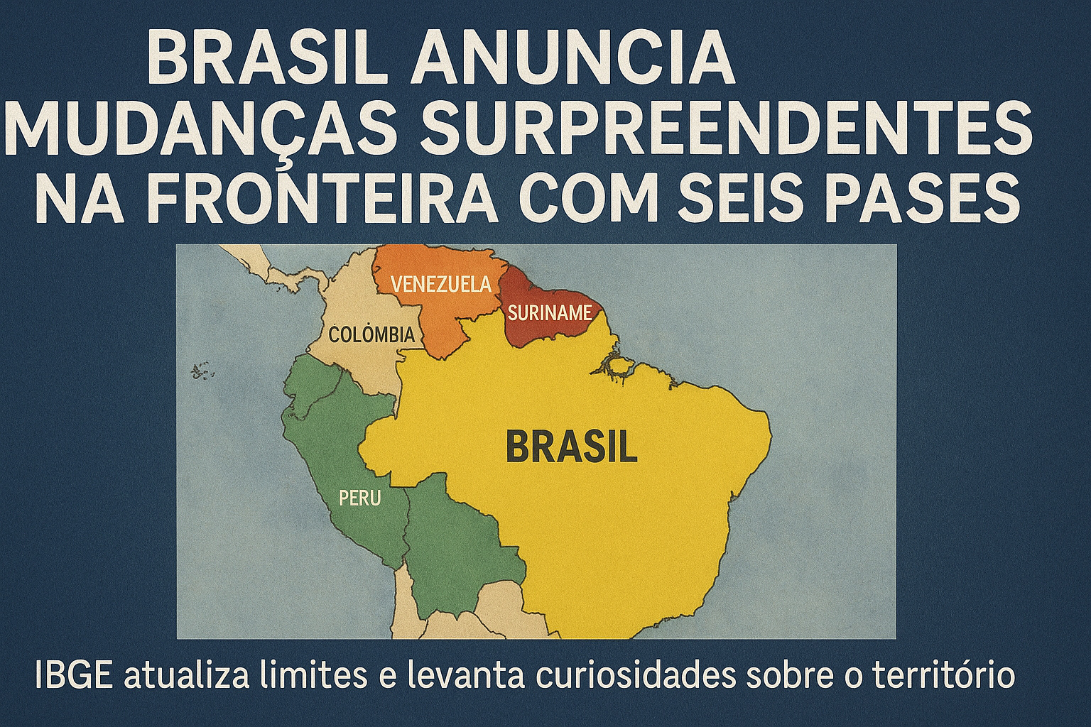
Brazil Alters Border With Six Countries After Update from IBGE, and Technical Changes Raise Curiosities About National Boundaries.
The Brazil has undergone significant changes in international borders after an update released by the IBGE this Wednesday (26).
The change, which involves six South American countries, shows how new cartographic analyses are redrawing parts of the national map and why this matters for territorial planning.
The changes appear in the seventh edition of the Continuous Vector Cartographic Base of Brazil (BC250), an essential tool used by public agencies and researchers. Thus, the country adjusts the representation of borders with French Guiana, Guyana, Venezuela, Suriname, Colombia, and Peru.
-
The world’s first octopus farm wants to open in the Canary Islands and is already provoking an international reaction: the plan aims to produce 3,000 tons per year.

-
Drought may be creating stronger superbugs in the soil and helping antibiotic resistance reach hospitals, warns a study highlighting a problem that could grow alongside extreme weather.

-
The biggest scam in history: Napoleon’s France deceived the United States by selling them a territory that was Spanish.

-
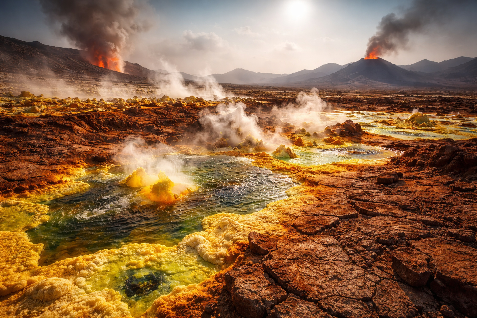
Why is the Danakil Desert so dangerous? It has unstable terrain and how extreme temperatures and toxic gases turn the region into one of the most hostile environments on Earth.

Despite the repercussions, changes in the international border do not modify the political-administrative division of Brazil or the other countries.
They therefore serve only as a technical reference, without official validity or legal character. Still, they generate curiosities and debates about the accuracy of Brazilian territorial delineation.
What’s Behind the Changes in Brazil’s Border
The changes released by IBGE arise from a continuous review process of the BC250, updated every two years. The base gathers detailed information to support territorial management, infrastructure planning, and environmental monitoring, in addition to allowing analyses on changes in boundaries and on the evolution of human occupation.
According to the institute, the update reflects improvements in mapping methods and the cross-referencing of data with international sources. This way, Brazil keeps up with modern cartographic standards and reduces historical discrepancies in the drawing of the international border.
Which Countries Had Revised Boundaries
The changes involve six countries that border the northern and northwestern territory of Brazil. Thus, the new record includes:
- French Guiana
- Guyana
- Venezuela
- Suriname
- Colombia
- Peru
Although these changes spark interest and may lead to misinterpretations, IBGE emphasizes that there is no real territorial impact. “The change has no official or probative validity,” the agency stated. In other words, border agreements remain exactly as before.
Why the Update Matters for Brazil
Even without legal effect, the new representation of boundaries helps to enhance studies on the Brazilian geographical space. It contributes, for instance, to infrastructure projects, defense, environmental monitoring, and public policies. Additionally, it improves the accuracy of printed maps, navigation systems, and academic databases.
This way, Brazil reinforces its commitment to international technical standards and keeps its cartography aligned with technological advances. The process also prevents lags that could interfere with research and structural planning.
Curiosities About the Evolution of Brazilian Boundaries
The borders of Brazil have undergone various agreements, treaties, and historical adjustments. Therefore, technical changes such as those released by IBGE help to understand how cartography tracks territorial dynamics. Furthermore, they show how neighboring countries adopt different mapping standards, which requires constant harmonization.
Thus, even small changes in the outlines attract attention — especially when involving biodiverse regions, indigenous areas, and strategic zones in the Amazon.
Update Reinforces the Role of Cartography in National Planning
The new edition of BC250 demonstrates how technology enhances knowledge about the territory. On the other hand, it reinforces that official cartography strictly follows the limits established by diplomatic agreements. Therefore, the update is a technical tool, not a political one.
Brazil also emphasizes that geospatial accuracy is essential for sustainable development policies, national defense, and integration with neighboring countries.


-

Uma pessoa reagiu a isso.