 Portuguese
  English
  Spanish
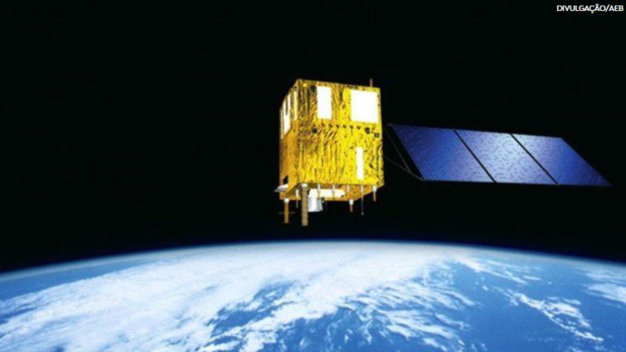


Understand How The New Generation Of Satellites With Radar Technology Is Revolutionizing Environmental And Security Monitoring, Enabling Continuous Oversight Of The Forest Against Illegal Deforestation.
The era of continuous monitoring of the Amazon has finally begun. Brazil now has the capacity to monitor illegal logging, the advance of mining, and other criminal activities in the forest 24 hours a day, thanks to the implementation of satellites with radar technology. This achievement, which overcomes the challenge of the dense cloud cover in the region, is a game changer in the country’s environmental and security policy, placing the new technology at the center of territorial protection strategy.
The new phase of monitoring is the result of a multifaceted approach. Sources from the Brazilian Air Force (FAB) confirm that satellites with radar technology are already fully operational, while statements from the Brazilian Space Agency (AEB) and the National Institute for Space Research (INPE) detail advancements in future projects. This hybrid strategy, which combines technology acquisition, international cooperation, and national development, aims to consolidate and expand the use of satellites with radar technology in the country.
The End Of “Blindness” In Climate: Why Radar Changes The Game In The Amazon
For years, monitoring the Amazon, while globally pioneering with systems like PRODES and DETER from INPE, suffered from a critical limitation: the dependence on optical satellites. These devices, which function like high-power cameras, require sunlight and clear skies to generate images, becoming ineffective at night and, particularly, during long periods of rain and cloud cover in the region, which can last for months.
-
Motorola launched the Signature with a gold seal from DxOMark, tying with the iPhone 17 Pro in camera performance, Snapdragon 8 Gen 5 that surpassed 3 million in benchmarks, and a zoom that impresses even at night.

-
Satellites reveal beneath the Sahara a giant river buried for thousands of kilometers: study shows that the largest hot desert on the planet was once traversed by a river system comparable to the largest on Earth.

-
Scientists have captured something never seen in space: newly born stars are creating gigantic rings of light a thousand times larger than the distance between the Earth and the Sun, and this changes everything we knew about stellar birth.

-
Geologists find traces of a continent that disappeared 155 million years ago after separating from Australia and reveal that it did not sink, but broke into fragments scattered across Southeast Asia.

This inability for continuous observation created a true “sovereignty vacuum,” as experts point out. Criminals took advantage of this window of invisibility to act. The satellites with radar technology (SAR) emerge as the definitive solution to this problem. Unlike optical sensors, radar is an active system: it emits its own microwave pulses that penetrate clouds, smoke, and darkness, “illuminating” the ground and recording what is there. This ability to see through climatic obstacles transforms oversight from reactive, measuring damage after it has been done, to proactive, allowing detection of illegal action at the moment it occurs.
Carcará: The Immediate Operational Capacity Of The FAB
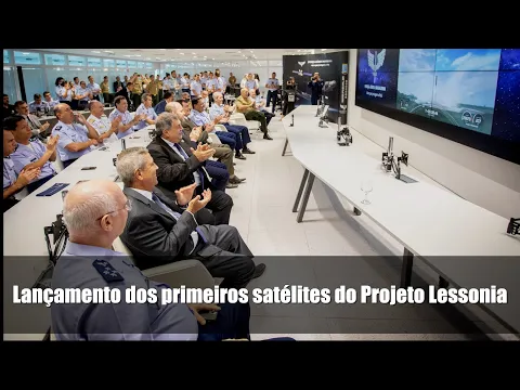
Brazil’s most immediate response to obtain this technology came from the defense sector. According to information from the Brazilian Air Force (FAB), the Lessonia Project launched the Carcará I and Carcará II satellites into orbit in May 2022. Acquired from the Finnish company ICEYE, these are the first high-resolution radar technology satellites operated by the country, addressing an urgent need for surveillance and providing crucial data for the national defense and monitoring system.
The Carcará satellites operate in a “dual-use” model, serving both military and civilian demands. While the Armed Forces use them for border surveillance and drug trafficking combat, their main civilian user is the Center for Managerial and Operational Systems for the Protection of the Amazon (CENSIPAM). It is CENSIPAM that processes these radar images and transforms them into actionable intelligence, distributing alerts about deforestation and illegal mining to regulatory agencies such as IBAMA and the Federal Police, enabling field operations with unprecedented precision and agility.
Expanding The Arsenal: The Next Satellites With Radar Technology
Alongside the acquisition of ready technology, Brazil is investing in long-term development. A historic milestone in this journey was the launch of Amazonia-1 in 2021, the first Earth observation satellite fully designed, integrated, and operated by the country, under the leadership of INPE. Although it is an optical satellite, its great strategic legacy was to validate in orbit the Multi-Mission Platform (PMM), a kind of versatile satellite “chassis” of Brazilian technology.
The success of the PMM, according to the Brazilian Space Agency (AEB) and INPE, was what qualified Brazil for the next major leap: the CBERS-6. In a strategic partnership with China, Brazil will provide the PMM platform, while the Chinese will develop the SAR payload. With a launch scheduled for 2028, this program will ensure the country access to another satellite with radar technology, strengthening the capacity for continuous monitoring and deepening national expertise in operating these systems.
The Private Sector Race For Satellites With Radar Technology
Completing the ecosystem, the private sector has also entered the race to develop and use satellites with radar technology. The Brazilian company SpotSat, as reported in news articles about the initiative, announced plans to develop the “Odail Spot One.” The project aims to meet the growing demand from agribusiness for environmental compliance, where the ability to monitor rural properties regardless of weather is a competitive and regulatory advantage.
The SpotSat initiative demonstrates the maturity of the Brazilian market and the creation of a new vector of innovation focused on this technology. If successful, the project will not only meet a vital commercial demand for the economy but also represent a significant advance in the provision of remote sensing data in the country. The existence of a private solution could complement governmental efforts, offering data with high frequency and customized services for different sectors that depend on satellites with radar technology.
What Is The Greatest Impact Of This New Technology For Brazil?
The definitive incorporation of satellites with radar technology into the Brazilian surveillance system is undoubtedly a milestone. The ability to “see through clouds” eliminates the main natural barrier to the oversight of the Amazon and other strategic areas.
What is the greatest impact that satellites with radar technology will bring to the future of the Amazon and security in Brazil? Do you believe that this technology can truly curb environmental crime or will it find new ways to be circumvented?
Leave your strategic perspective in the comments; we want to understand how Brazilians perceive the future of our technological and environmental sovereignty.


Great article, thank you for sharing these insights! I’ve tested many methods for building backlinks, and what really worked for me was using AI-powered automation. With us, we can scale link building in a safe and efficient way. It’s amazing to see how much time this saves compared to manual outreach.