 Portuguese
  English
  Spanish
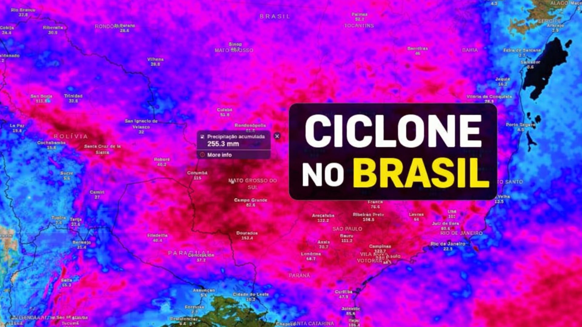
Period of Instability Advances Across the Country With Large Amounts of Rain, Severe Storms and the Presence of Cyclones Near the Coast, Increasing the Risk of Flooding, Landslides and Disruptions in Urban and Rural Areas, Especially in the Midwest, Southeast and South, According to Recent Meteorological Projections.
In the coming days, Brazil is expected to face a sequence of severe storms and intense rains spread across a wide area of the national territory, with more significant impacts anticipated for areas in the Midwest, Southeast and South.
According to meteorological projections, part of this precipitation will be organized by the presence of two low-pressure systems, with potential to evolve into cyclones near the coast between the South and Southeast regions, a configuration that increases the chance of heavy rain, wind gusts and hail episodes.
In some areas, the projected accumulation may reach or exceed 250 mm during the period analyzed by numerical models, which increases the risk of disruptions such as flooding and landslides.
-
Researchers in the U.S. have created a flying robot that transforms into a land vehicle while still in the air. The technology, based on aerodynamic transition, converts landing into a scene worthy of Transformers and redefines mobility between sky and ground.

-
Spread across two continents, with 197 parabolic antennas in South Africa, 131,000 2-meter antennas in Australia, and a range of up to 150 km, the SKA begins to “listen” to the Universe on an unprecedented scale and accelerates the search for black holes, primitive galaxies, and nearly invisible radio signals.

-
Goodbye batteries: a new sensor created by Japanese scientists uses sweat as an energy source and points to a promising path for more sustainable devices, with greater autonomy and less need for frequent recharging.

-
The Brazilian Army inaugurated the assembly line for the Guaicurus armored vehicle with a contract for 420 units by 2033, and the same vehicle has already been tested in combat in Afghanistan and Lebanon by European armies.

The scenario is particularly concerning where the rain is expected to concentrate over a short period of time, dumping large volumes in a few hours, as well as in areas where the soil is already saturated and rivers are operating at elevated levels.
Presence of Cyclones and Cold Fronts Intensifies the Rain
Situations like the one predicted often occur when low-pressure centers strengthen over the ocean or near the coast, beginning to organize cold fronts and persistent moisture corridors over land.
Even when the cyclone’s center moves away toward the sea, the mechanisms associated with the system continue to operate, encouraging the formation of heavy clouds and maintaining instability on land.

Among these mechanisms are the cold front, moisture convergence and low-level atmospheric circulation, factors that, combined, favor the occurrence of heavy rain and storms.
In this context, meteorological services have indicated an increased risk of severe storms in the central-southern part of the country, with recent alerts for large volumes of rain and storms, especially in areas of the Southeast.
In states like São Paulo, atmospheric instability also raises the possibility of hail, depending on the intensity of the clouds and local conditions.
First System Already Causes Effects Before Moving Away
The first of the two cyclones is likely to consolidate when the low-pressure center closes, a phase where the atmospheric circulation begins to exhibit greater organization.
Nevertheless, the effects of this system are often felt even before complete formation, as the drop in pressure and the increase in moisture transport precede the peak intensity moment.
For this reason, heavy showers and storms may occur during the atmospheric organization process, with greater frequency between the South and Southeast of the country.
Subsequently, the system’s movement toward the ocean is expected, but this does not mean immediate relief on land, as the associated cold front continues to advance.
Upon encountering warm, moist air, this front favors the formation of storms with intense wind gusts and, in some episodes, hailfall.
The exact location of the most affected areas may vary with each model update, which face difficulties in defining in advance the precise point and moment of formation of these systems.
Second Cyclone and Atmospheric River Increase the Risk in the Midwest
In the next stage of the forecast, the deepening of a new area of low pressure in the South of the country stands out, with potential to give rise to a second cyclone in the following days.
In such configurations, the low pressure acts as an anchor in the atmosphere, helping to sustain a persistent circulation pattern and channeling moisture from the North.

This intense flow of water vapor, known as atmospheric river, transports moisture from the Amazon region to the central-southern part of Brazil, creating favorable conditions for heavy rains.
When this corridor encounters instability, precipitation tends to increase in strength and frequency, raising the risk of localized extreme events.
Weather model projections indicate that the atmospheric river may operate more intensely over Mato Grosso do Sul, increasing the chance of storms with concentrated rain over a short period.
In these situations, the danger lies not only in the total accumulated amount but also in the speed at which the rain can fall.
States at Greater Risk of High Accumulations
In general, the forecast indicates a higher likelihood of elevated volumes in the Midwest, Southeast and South of the country throughout the period.
The most delicate scenario is projected for Mato Grosso do Sul, where accumulations may exceed 250 mm, with some rain occurring as an extreme event between the weekend and the beginning of the following week.
São Paulo is also on the path of instabilities, with forecasts for heavy rain in different regions, especially in the northern half and the western border of the state.
Depending on the positioning of the areas of instability, the episodes may be accompanied by storms, wind gusts and hail.
In Minas Gerais, the main concern is the persistence of rain over several days, which may worsen the situation in areas where the soil is already saturated.

Paraná and Santa Catarina complete the list of states on alert, with greater sensitivity in eastern strips and metropolitan areas, where rain is likely to be more frequent and, at times, intense.
Risk of Flooding, Floods and Landslides Increases
When large volumes of rain concentrate over a few hours, the risk of flooding and sudden inundations increases significantly.
Under these conditions, urban drainage and surface runoff cannot keep up with the intensity of precipitation.
In rural areas, streams and smaller rivers can rise rapidly, reducing the available response time and increasing the potential for damage.
In regions with a history of unstable slopes, the scenario becomes even more critical, as the saturated soil loses cohesion.
This factor can facilitate landslides, especially in hilly areas with irregular occupation, slope cuts, and little vegetation cover.
For authorities and emergency services, continuous monitoring is essential, as heavy rain can move rapidly from one region to another.
From the perspective of the population, following safety guidelines remains critical, such as avoiding crossing flooded areas and respecting official alerts.
With the possibility of successive storms and uncertainty about where extreme rain may concentrate, the pressing question is whether your city is prepared to respond quickly if the worst-case scenario materializes.


-

-

-

-

-

-

308 pessoas reagiram a isso.