 Portuguese
  English
  Spanish
Week marked by frequent rain, persistent heat, and risk of storms in several regions of the country, with highlights for the South under the influence of an extratropical cyclone and advancement of a cold front, while other areas face instability caused by high humidity and atmospheric systems.
The week between March 24 and 30, 2026 will be marked by instability in much of Brazil, with frequent rain, persistent heat, and risk of storms in areas of the South, Southeast, Midwest, and the Amazon.
In the South, the formation of an extratropical cyclone near Rio Grande do Sul, combined with the advancement of a cold front, concentrates the greatest potential for heavy rain, winds, and possible hail, while other regions remain under the influence of high heat and humidity.
South concentrates the greatest risks with cyclone and cold front
In the South, the most delicate situation is concentrated over Rio Grande do Sul, where the combination of the cyclone and the cold front keeps the sky overcast and favors episodes of more intense rain throughout the week.
-
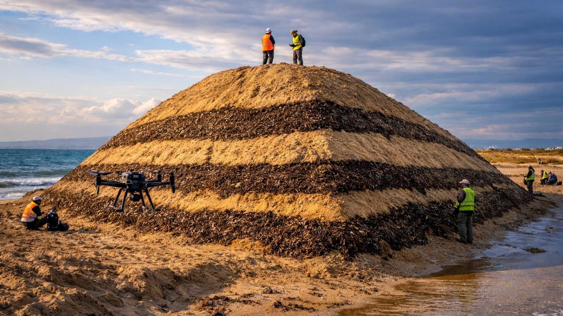
Spain surprises the world by erecting 62 artificial dunes, mixing sand with natural remains of posidonia, and causing the structure to lose only 1.4% of its volume in 1 year.
-
With 16 Bulava missiles, improvements in acoustic stealth, and a design focused on silent patrols, Russia’s nuclear submarine was born to ensure Moscow’s invisible retaliation and has become one of the pillars of its maritime strength.

-
‘Populous’ city in Rio among the worst in Brazil in national ranking and exposes silent development crisis.

-
Couple buys house in the South Zone of São Paulo, opens a hidden door in the garage, and finds a secret wine cellar with dozens of old wines forgotten since the 1970s.

The forecast indicates a higher risk for storms in the state, with the possibility of gusty winds, lightning strikes, and localized hail, especially between Wednesday and Thursday.
In Porto Alegre, the temperature remains more restrained at the beginning of the period, with a maximum of around 24°C this Tuesday and conditions for rain with storms on Wednesday.
The yellow alert from Inmet for the capital of Rio Grande do Sul reinforces the forecast of rain between 20 and 30 millimeters per hour, in addition to winds of 40 to 60 km/h.
Santa Catarina and Paraná also enter the path of instabilities, although with a less severe outlook than that observed in the gaucho territory.
The trend is for rain at various times, but with a gradual reduction in intensity after the more organized passage of systems over the South Region.
Southeast will have heat, showers, and attention in Minas Gerais
In the Southeast, the heat continues to be present, but it is no longer synonymous with stable weather.
The action of a cyclonic vortex at high levels favors an increase in showers, especially between the east of Minas Gerais and Espírito Santo, while São Paulo and Rio de Janeiro continue with muggy afternoons and more irregular rain.
In the capital of São Paulo, the expected maximum is around 30°C this Tuesday and 29°C on Wednesday, with more clouds and a chance of precipitation from the second half of the week.
In Belo Horizonte, the scenario is more unstable, with maximums between 26°C and 27°C in the coming days and the presence of alerts for accumulated rain and intense showers.
The interior of Minas Gerais deserves additional attention, as part of the state is under a storm warning, with forecasts of higher volumes, intense winds, and a risk of hail in specific areas.
This pattern keeps the Southeast in a transitional phase, where the heat does not disappear but coexists with heavy clouds and more widespread episodes of intense rain.
Midwest remains hot and with risk of isolated storms
In the Midwest, the week will be hot and humid, with showers distributed across the four states and reinforcement of instabilities between March 25 and 27.
The forecast points to rain throughout the region during this period, with a higher risk for storms in areas of Goiás, Mato Grosso, Mato Grosso do Sul, and the Federal District.
In Brasília, the expected maximum is around 27°C this Tuesday and 25°C on Wednesday, with a series of alerts for storms and intense rain.
There is a possibility of gusts between 60 and 100 km/h, in addition to new episodes of instability throughout the week.
The maintenance of heat at the surface, combined with the available humidity, sustains the formation of heavy clouds early in various points of the region.
This indicates that rain should not be restricted to the late afternoon, repeating a typical pattern with isolated storms, localized flooding, and rapid weather changes.
North concentrates greater volumes of rain and sensation of mugginess
The North Region continues to be among the areas with the highest potential for rain in the country, especially in the Amazonian strip.
Manaus has a forecast maximum of 33°C this Tuesday, followed by days with storms and frequent showers.
There is an alert for intense rains with significant accumulations and strong winds.
In addition to Amazonas, the forecast indicates significant rain in the extreme north of the country and in parts of Pará and Amapá.
The action of the Intertropical Convergence Zone reinforces episodes of more voluminous precipitation in these areas.
The result is a persistent feeling of mugginess, alternated with heavy showers and short intervals of improvement.
In urban areas, this pattern increases the risk of localized disruptions, such as rapid flooding and impacts on transportation.
Northeast has contrast between rainy north band and warmer coast
In the Northeast, the distribution of rain will remain uneven throughout the week.
Maranhão and Piauí appear among the states with the most relevant accumulations, with the possibility of volumes above 60 millimeters and points that may exceed 100 millimeters.
Meanwhile, the eastern coast of the region will have warmer days with more sun.
Despite this, brief showers cannot be ruled out over the next few days.
In Recife, the expected maximum ranges between 31°C and 33°C, with more irregular rain compared to the north of the region.
This scenario reinforces the contrast between the different sectors of the Northeast, maintaining the typical pattern of transition between seasons, with heat, high humidity, and increased instabilities in various areas of the country.


Seja o primeiro a reagir!