 Português
  Inglês
  Espanhol
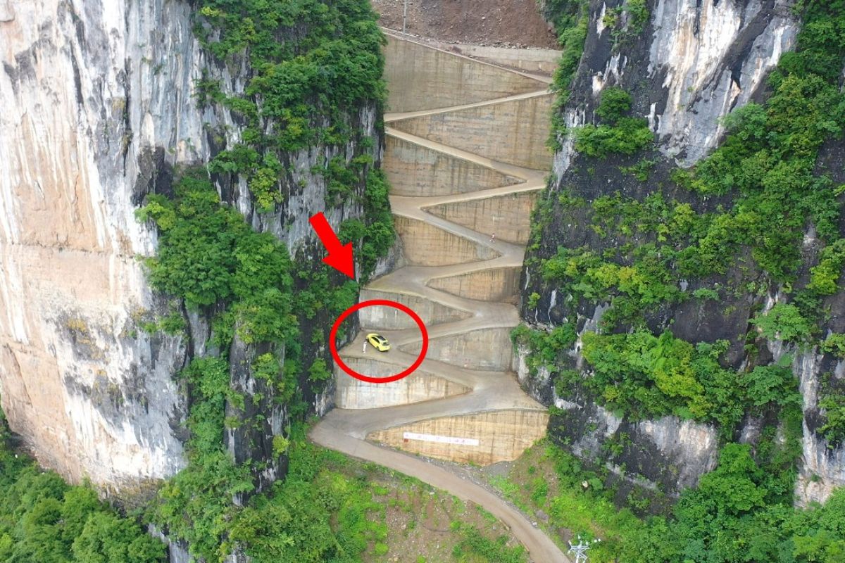


With 18 Hairpin Turns, 3.7 Km Long and a Stretch of Cliff That Cost Millions, the Z-Shaped Road of Lingpaishi Connects Isolated Villages in Chongqing, Cuts Steep Slopes and Becomes an Extreme Showcase of Chinese Engineering Amidst the Mountains
In the mountains of Wuxi County, Chongqing, a Z-shaped road carved into a cliff has become a symbol of challenge and curiosity. The Lingpaishi Highway, built as the sole access to Tianping Village, combines steep elevation, consecutive hairpin turns, and stretches clinging to the abyss, enough to keep even experienced drivers on high alert.
With a length of 3.7 kilometers and an investment exceeding 6 million yuan, the road was designed in a zigzag pattern to conquer an extremely steep slope, reaching an elevation of almost one thousand meters. The Z-shaped road is not just a functional pathway, but a design that mixes risk, stunning scenery, and strong visual appeal, which explains why videos and images of the area have quickly spread across social networks.
Where the Z-Shaped Road Is Located and Why It Was Built

The Z-shaped road, known as the Lingpaishi Highway, is located in Minzhu Village, Dahe Municipality, Wuxi County, Chongqing.
-
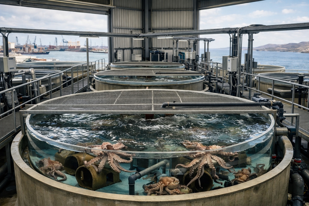
The world’s first octopus farm wants to open in the Canary Islands and is already provoking an international reaction: the plan aims to produce 3,000 tons per year.
-
Drought may be creating stronger superbugs in the soil and helping antibiotic resistance reach hospitals, warns a study highlighting a problem that could grow alongside extreme weather.

-
The biggest scam in history: Napoleon’s France deceived the United States by selling them a territory that was Spanish.

-
Why is the Danakil Desert so dangerous? It has unstable terrain and how extreme temperatures and toxic gases turn the region into one of the most hostile environments on Earth.


The name comes from two rock formations flanking the road, resembling stacks or tiles embedded in the ground, creating a natural corridor between cliffs.
This highway is the only road access to Tianping Village, which justifies the heavy investment in such a remote area.
The 3.7-kilometer stretch consumed over 6 million yuan, with the 453-meter section between the Lingpaishi rocks alone requiring more than 4 million yuan, reflecting the great complexity of the cliffside construction.
How the Z-Shaped Road Was Designed on the Cliff

The topography of the slope left little room for alternatives.
To allow vehicles to ascend from the base of the mountain to the upper plateau, engineers adopted a zigzag design, creating the Z-shaped road with 18 hairpin turns distributed along the ascent.
From a distance, the highway resembles a zipper embedded in the mountain wall. Aerial views show the road cutting through the cliff at successive levels, resembling giant steps.
The Z-shaped road follows the extreme incline, reducing the angle of ascent, but concentrates very tight curves in succession, which requires constant attention and complete vehicle control.
Extreme Incline and Curves That Test Trucks
Video accounts from those who traverse the route highlight that, at some points, drivers practically have to “break” the steering wheel to complete the turn.
There are mentions of a section considered the most critical, with around a dozen consecutive steeper curves, where large trucks face the ascent at the limit of adhesion.
In certain turns, the usable road width feels small compared to the length of an average SUV, reinforcing the sensation of always being very close to the edge.
For those driving trucks or buses, each turn of the Z-shaped road represents a calculated maneuver, where any mistake can mean brake system wear, loss of traction, or the need for sudden correction.
Local Drivers’ Experience on the Z-Shaped Road
Videos recorded on-site show locals reporting that the road is known as one of the most dangerous in the region.
There are accounts of drivers with decades of experience, some with over 30 years behind the wheel, who still face the stretch with respect and heightened caution.
Motorcyclists and small car drivers also report the impact of the combination of tight turns, strong winds, rain, and fog.
On days of dense fog, the Z-shaped road takes on an even more risky air, with sections where the cliff practically disappears from sight, replaced by a white backdrop of clouds and mist.
From Mandatory Road to Extreme Mountain Attraction
Over time, the Z-shaped road of Chongqing has begun to attract not only locals but also visitors interested in capturing the journey in photos and videos.
Travel enthusiasts and channels dedicated to mountain roads have started to include the stretch in their itineraries, precisely because of the combination of scenery, cliff, altitude, and unusual design.
The view from the top is often described as a scene of towering mountains shrouded in clouds, with the road cutting through the slope in a broken line.
For some, it is a clear showcase of how Chinese road engineering has advanced over terrains once considered impassable.
For others, the Z-shaped road is less of a tourist attraction and more of a nerve-wracking test for any driver.
Risk, Beauty, and the Cost of Connecting Isolated Communities
Projects like the Lingpaishi Highway help illustrate the technical and financial cost of integrating mountain communities into the road network.
A single segment of 453 meters consuming over 4 million yuan shows that in cliff terrain, each curve requires excavation, containment, drainage, and paving under extreme conditions.
At the same time, the Z-shaped road highlights the dilemma between safety and access: the road is essential for the movement of residents of Tianping Village, but imposes a level of attention, maintenance, and driver training far above what is found on regular flatland roads.
On days of heavy rain, wind, or snow, the choice between ascending or waiting can turn into a critical decision.
And you, would you dare to drive on the Z-shaped road of Chongqing to see this scenery up close, or would you prefer to admire this extreme cliff solely through images?


Mole. Se .o pessoal da China gosta de aventura e perigo, é só dirigir na Av Brasil, Linha Vermelha e Linha Amarela no Rio de Janeiro, com arrastão, tiroteios, alagamentos de dia ou de noite
Deveriam fazer um muro de contenção, pois é muito fácil do freio falhar.
Mole essa estrada pra nós que estamos acostumados com a serra de Ubatuba