 Portuguese
  English
  Spanish
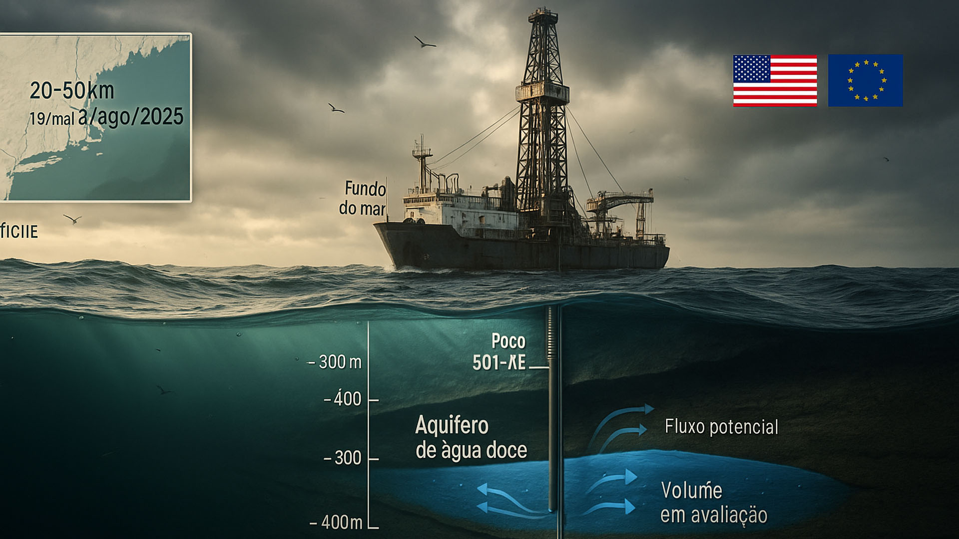
Scientists Drilled The Bottom Of The Atlantic Off The Northeast Coast Of The USA And Confirmed A Vast Submarine Freshwater Aquifer. The Find Could Relieve The Global Water Crisis If Technical Challenges Are Overcome.
Scientists Spent Three Months Drilling The Seafloor And Collecting Samples Between 300 And 400 Meters Below The Seabed, Off The New England Coast. They Found Water With Salinity Much Lower Than That Of The Sea And Close To Recommended Potability Standards By US And International Agencies. The Material Is Being Sent For Laboratory Analyses.
The Effort Mobilized Dozens Of Researchers From Various Countries And Drilling 20 To 50 Km From The Coast, According To Reports From US National Outlets. The Goal Is To Directly Sample The Aquifer Mapped Since 2019 And Test Its Extent, Composition, And Age.
The Campaign Was Part Of The Expedition 501 – New England Shelf Hydrogeology, Led By The European Consortium ECORD Under The IODP³, With Offshore Operations Between May 19 And August 1, 2025 Departing From The Port Of Bridgeport (Connecticut). The Onshore Phase Is Expected To Start On January 14, 2026 At The Bremen Repository In Germany.
-
While the world looks at oil, the war with Iran is already disrupting helium supply from Qatar, affecting car and iPhone chips, threatening AI expansion, and putting pressure on aluminum packaging at the highest value in four years.

-
Global warming will expose a treasure hidden under the ice of Antarctica and may spark an international dispute over gold and valuable minerals.
-
A street vendor from Praia Grande built a robot made of scrap from scooters and washing machines that pulls his popcorn cart on the beach, emits sounds, and interacts with customers, becoming an attraction on the coast of São Paulo.
-
The specifications of the Xiaomi 18 Pro Max have been leaked, and the highlight is a dual 200 MP camera with a new 22-nanometer technology that promises to consume less energy and capture details in shadows and bright areas using LOFIC HDR.


Why Is There Freshwater Beneath The Sea
The Existence Of This Reservoir Was Already Known But Little Explored. In 2019, Teams From The Woods Hole Oceanographic Institution And Columbia University Mapped A Giant Strip Of Freshwater Beneath The Atlantic, From Massachusetts To New Jersey, Possibly Beyond, Totaling Almost 500 Km. It Was Described As The Largest Formation Of Its Kind Ever Identified.
How Did This Water Get There? Two Main Hypotheses Guide The Testing: Ancient Infiltration During Periods Of Lower Sea Level Or Contribution From Glacial Melt And Rain. Professor Holly Michael (University Of Delaware) States That The Scenario Of Reduced Sea Level May Explain The Past Recharge Of These Offshore Coastal Aquifers.
Knowing The Age Of The Water Is Important Because Young Waters Would Indicate Active Recharge, While Old Waters Suggest A Finite Resource. Expedition Leaders Estimate They Will Disclose The Approximate Age Of The Samples In About Six Months After Analyses.
Low Salinity Offshore Freshwater Could Supply Cities
The Drilling Recovered Sediments And Deep Freshwater Samples At Multiple Points, With Salinity Levels Close To The Recommended Potability Limit. This Shortens The Treatment Path Compared To Conventional Desalination, Which Could Reduce Energy Costs For Producing Drinking Water For Coastal Cities.
According To Geophysicist Brandon Dugan (Colorado School Of Mines), Co–Chief Of The Campaign, The Answers Regarding Origin, Age, And Sanitary Safety Will Determine The Viability For Large Scale Use. The Researcher Sees Operational Potential Within Up To 10 Years, Provided That Science And Engineering Confirm The Path.
Researcher Eric Attias (University Of Texas At Austin), Not Involved In The Project, Evaluates That The Aquifer Is Vast And Could “Supply A Metropolis The Size Of New York For Hundreds Of Years”, While Exercising Caution Regarding Impacts And Limits. It Is A Hope For Coastal Populations.
Potential Impact On The Global Water Crisis
Nearly Half Of The World’s Population Lives Within 96 Km Of The Coast And Depends On Continental Aquifers, Which Are Currently Under Pressure From Overpumping And Saltwater Intrusion Linked To Sea Level Rise. Submarine Reservoirs Could Serve As An Alternative Source In Areas With Water Stress And Nearby Infrastructure.
The Discovery Revives The Debate On Water Security And Climate Resilience. In Extreme Drought Scenarios, Cities Could Supplement Their Supply With Submarine Freshwater, Reducing The Dependence On More Energy-Intensive Desalination Works.
However, Experts Emphasize That It’s Not A One-Size-Fits-All Solution. Without Demand Management, Network Losses, And Ground Aquifer Protection, The Gain May Be Temporary. Integrated Water Resource Planning Remains A Priority.
Costs, Risks, And Regulatory Milestones
Bringing Heavy Water From The Seabed To The Surface And Transporting It To Shore Requires Energy And Logistics. Proposals Exist To Use Wind Energy To Reduce Emissions, But The Economic Viability Will Depend On Each Project. Who Pays And Who Regulates Are Also Important: The Extraction Would Occur In Federal Waters, With Fees Passed To States And Municipalities.
There Are Risks Of Contamination By Saltwater Above And Below The Aquifer If Pumping Alters Natural Gradients. Another Concern Is To Avoid Interference With Ground Aquifers If There’s Hydraulic Connection. Continuous Geophysical Monitoring And Well-Designed Wells Will Be Essential.
According To Mission Documents, The Expedition 501 Was Structured For Controlled Tests And Sample Collection, Not For Production. The Data Generated Now Will Support Engineering Studies, Hydrogeological Modeling, And Environmental Assessments Before Any Licensing.
In Light Of The Global Water Crisis, Should Submarine Aquifers Be Included In Planning, Or Should The Focus Remain On Conservation And Reuse? Do You Think It Is Worth Investing Billions To Pump Water From Subterranean Sea Sources, Or Is It A Risky Shortcut That Could Distract From Solutions On Land? Leave Your Opinion In The Comments.


-

-

-

-

-

22 pessoas reagiram a isso.