 Portuguese
  English
  Spanish
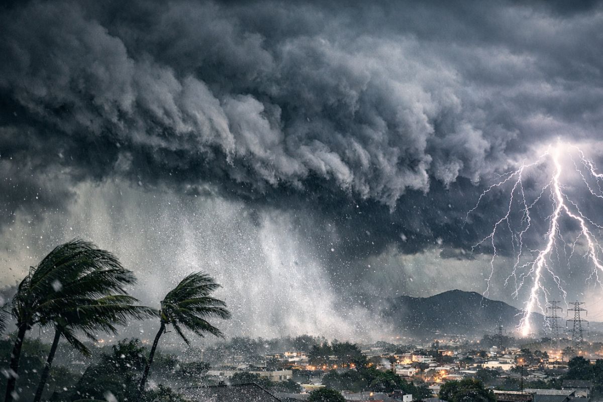


Combining Intense Heat, High Humidity, and Winds at Different Levels of the Atmosphere, Storms Are Expected to Hit Santa Catarina from Friday to Sunday, with Greater Concern for the North and North Coast, Where Civil Defense Already Anticipates Heavy Rain, Strong Gusts, Hail, and Impacts Such as Roof Damage, Flooding, Flash Floods, and Landslides.
The storms expected for Santa Catarina mark a sharp change in the weather pattern after days of intense heat. Instability begins as early as Friday afternoon (13), with lightning, strong winds, and the possibility of hail, and is likely to affect different areas of the state within a risk window extending until Sunday (15).
In the North and North Coast, the concern is greater because the rain can accumulate quickly, especially between late afternoon and evening. In this context, Civil Defense and residents enter a phase of heightened alert to reduce impacts such as flooding, flash floods, roof damage, and localized landslides.
What Explains the Shift and Why Storms Gain Strength
The change in the scenario occurs due to the combination of three interrelated factors: intense heat near the surface, high humidity available for the formation of heavy clouds, and wind circulation at different levels of the atmosphere.
-
Motorola launched the Signature with a gold seal from DxOMark, tying with the iPhone 17 Pro in camera performance, Snapdragon 8 Gen 5 that surpassed 3 million in benchmarks, and a zoom that impresses even at night.

-
Satellites reveal beneath the Sahara a giant river buried for thousands of kilometers: study shows that the largest hot desert on the planet was once traversed by a river system comparable to the largest on Earth.

-
Scientists have captured something never seen in space: newly born stars are creating gigantic rings of light a thousand times larger than the distance between the Earth and the Sun, and this changes everything we knew about stellar birth.

-
Geologists find traces of a continent that disappeared 155 million years ago after separating from Australia and reveal that it did not sink, but broke into fragments scattered across Southeast Asia.

When these elements align, the atmosphere gains energy to organize stronger bursts of rain, with electrical discharges and gusts.
In practice, this arrangement does not produce just “ordinary rain.” It favors concentrated events, with greater intensity over shorter time frames, which increases the potential for urban and rural disruptions.
Therefore, the shift in weather should not be treated as a routine change: the scenario requires continuous monitoring of risk, especially in areas with a history of critical drainage.
Where the Risk Increases First in the North and North Coast

The Civil Defense of São Francisco do Sul and Araquari has already alerted to potential occurrences, and the warning extends to the North and North Coast of Santa Catarina. This means that monitoring is not restricted to a single municipality: there is a regional concern about the behavior of rain and wind over several days.
Between late afternoon and early evening on Friday, the trend is for instability to intensify in the North Coast, with heavy and intense rain in a short period.
This type of dynamic raises the risk of flash floods and flooding almost simultaneously, as well as increasing the chance of landslides in susceptible areas, especially where the soil is already starting to lose absorption capacity.
When heavy rain combines with gusts and hail, the problem becomes not just hydrological but also structural. Roof damage, falling objects, and local interruptions can occur in sequence, requiring quick responses from residents, public services, and emergency teams.
Friday, Saturday, and Sunday: The Sequence of Instability and the Cumulative Effect
On Friday (13), the storms will make their appearance early in the afternoon, with lightning, wind, and the possibility of hail. As it progresses toward the end of the day, instability tends to organize more forcefully in the North and North Coast, concentrating greater volumes over shorter intervals.
On Saturday (14), the day starts with persistent rain along the Santa Catarina coast. In the afternoon, the forecast indicates new storms, maintaining a moderate to high risk for occurrences associated with bad weather.
This creates a scenario of continuity: even without a single isolated extreme event, the repetition of episodes increases the wear and tear on urban infrastructure.
On Sunday (15), instability remains and keeps the risk of new reports of flooding, flash floods, and landslides, with special attention to areas where the soil is saturated.
The cumulative effect of rain is one of the most critical points of the weekend, as it reduces safety margins and accelerates the formation of chain occurrences.
How to Reduce Damage During Storms: Practical Safety Guidelines
During storms, the recommendation is to seek shelter in a safe location, away from windows and objects that could be thrown by the wind. This simple measure reduces the risk of injury during moments of more intense gusts and falling debris.
In case of strong winds, the guidance is to avoid staying close to trees, signs, walls, and power poles.
The logic is preventive: exposed structures and elements can collapse or suffer sudden impacts, especially when the soil is wet and winds are accelerating.
In flooding situations, the safest conduct is not to cross flooded streets, bridges, or submerged walkways. The depth and force of the water can be underestimated, and the risk of accidents increases significantly when visibility is reduced or there is a current.
For emergencies, Civil Defense can be contacted at 199 and the Volunteer Firefighters at 193. It is also possible to receive official alerts via SMS: simply send the home ZIP code to the number 40199, which helps anticipate decisions regarding movement, property protection, and care for family members.
What to Observe in the Coming Hours to Decide More Safely
In a scenario like this, the focal point is not just knowing that it will rain, but identifying when instability changes levels.
Signs such as a rapid increase in wind, abrupt darkening of the sky, and the advance of intense rain in a short interval should be treated as triggers to seek shelter and halt unnecessary movements.
Another important measure is to align decisions at home and at work: define an alternative route, avoid areas known for flooding, and keep emergency contacts accessible. With risk distributed between Friday and Sunday, preparation ceases to be sporadic and becomes continuous, with daily reviews of local conditions.
The forecast for the coming days indicates a consistent shift: after the heat, the storms gain ground and raise the risk of impacts in the North and on the North Coast of Santa Catarina. The scenario demands technical attention, quick responses, and preventive behavior to reduce damage and avoid accidents.
In your neighborhood, what is the first sign that the rain is going to become a real problem: a street that floods quickly, wind that blows off roofs, or a hillside that starts to give way? And what practical measure has worked best to protect your family during such episodes? Share your experience objectively.


É mais só profecias do Apocalipse não é normal estes eventos da natureza