 Portuguese
  English
  Spanish
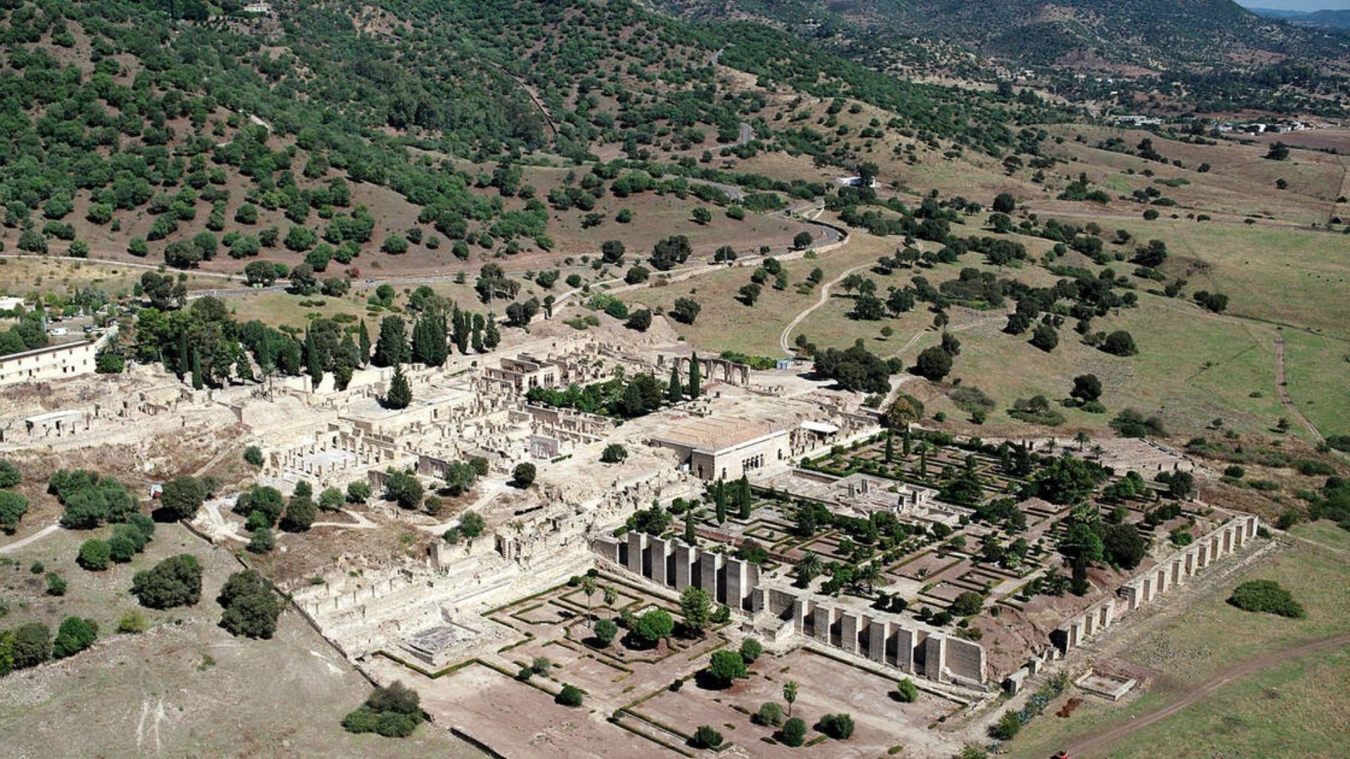
LiDAR Technology Applied to the Spanish Relief Reveals Signs of a Vast 10th-Century Palatial City Possibly Linked to Almanzor’s Power in Córdoba. Detailed Topographic Analysis Identified Buried Urban Patterns That May Indicate the Location of the Missing Madinat al-Zahira.
A study led by researcher Antonio Monterroso Checa from the University of Córdoba indicates that it has more accurately located the area where Madinat al-Zahira, the palatial city built by Almanzor in the 10th century, may have existed and which vanished after the political crisis that shook the caliphate of Córdoba.
The proposal places the enclave in the far east of the Spanish city, near Alcolea and the Pendolillas area, about 12 kilometers from the current Mosque-Cathedral.
The research gained traction with the use of LiDAR data from the National Geographic Institute of Spain, a remote sensing technology that allows for mapping relief in three dimensions with high detail.
-
After decades of failed attempts, Brazil is once again looking to space with an orbital rocket measuring 12 meters, weighing 12 tons, costing R$ 189 million, and scheduled for launch in 2026, in a new race to finally achieve autonomous access to orbit.

-
The Earth will plunge into a few minutes of darkness in broad daylight in August 2026, when a total solar eclipse transforms the sky into one of the most impressive astronomical phenomena in recent years.

-
How the terraforming of Mars can transform the planet: artificial aerosols can increase the temperature by up to 35°C in 15 years, creating conditions for liquid water.

-
Scientists drilled nearly 8,000 meters into the ocean floor above the fault that caused the 2011 tsunami in Japan and discovered that a layer of clay 130 million years old was responsible for making the wave much worse than any model had predicted.


From this material, the archaeologist identified linear and geometric anomalies beneath the surface of the ground, consistent with a planned urban layout on a large scale.
Subterranean Structures Indicate Possible Islamic Palatial City
According to the proposal published in the academic journal Meridies. Estudios de Historia y Patrimonio de la Edad Media, the area attributed to the possible Madinat al-Zahira reaches about 120 hectares.
The size is striking because it is close to the dimensions associated with Madinat al-Zahra, the famous palatial city founded by Abd al-Rahman III on the outskirts of Córdoba, on the opposite bank of the caliphal expansion.
The analyzed digital models reveal marks that exceed one kilometer in length, as well as quadrangular and rectangular traces distributed across different topographic levels.
For the researcher, this organization suggests a set of architecture adapted to the terrain, but guided by a coherent urban design, rather than spontaneous occupation or disorderly growth.
The work also supports that this is the first hypothesis about the location of Madinat al-Zahira backed by verifiable physical evidence.

The article itself states that over time, the city has already been located at 22 different points in Córdoba and its surroundings, without sufficient archaeological evidence to settle the debate.
Political Power and Monumental Rivalry in the Caliphate of Córdoba
Madinat al-Zahira occupies a central place in the memory of al-Andalus because it was conceived as the seat of power for Almanzor, also known as Abu Amir al-Mansur.
He wielded effective control of the caliphate of Córdoba between 978 and 1002, although formal power remained in the hands of Caliph Hisham II.
In this context, the new palatial city served as the political, administrative, and symbolic center of his authority.
Medieval sources associate the foundation of the complex with a strategy of political assertion.
By creating his own city, Almanzor shifted the axis of government and responded monumentally to the tradition represented by Madinat al-Zahra, the grand showcase of the Umayyad caliphate in the 10th century.
The scale similarity pointed out by the study reinforces this historical reading regarding the architectural rivalry between the two palatial complexes.
The disappearance of the site, in turn, helped to amplify the archaeological mystery.
The city was sacked and destroyed during the fitna of al-Andalus, the civil war that fragmented the caliphate in the early 11th century.
Unlike Madinat al-Zahra, whose ruins could be identified and excavated in modern times, Madinat al-Zahira ended up buried by time without a consensual location.
LiDAR Technology Reveals Hidden Urban Patterns in the Terrain
LiDAR stands for Light Detection and Ranging, a system that uses laser pulses to map surfaces with high accuracy.
In practice, the method emits laser pulses from airborne sensors and measures the return of these signals after contact with the ground.
With millions of points captured, it becomes possible to generate digital models capable of evidencing minimal variations in altitude and hidden traces under vegetation, agriculture, or recent transformations of the landscape.
In the case of Córdoba, the third LiDAR coverage of the Spanish program provided more detailed images than previous surveys.
Monterroso Checa cross-referenced this material with historiographical analysis, medieval Arab sources, and morphological reading of the territory.
This combination allowed for the revision of old hypotheses and a more consistent delimitation of the area that could have housed Almanzor’s city.
Still, the study does not present the discovery as definitive proof in the classical archaeological sense.
What exists at this moment is a robust localization proposal based on topographical data, historical interpretation, and spatial correspondence with documentary descriptions.
Archaeological Investigation Still Depends on Excavations
The new stage of the discussion should rely on fieldwork capable of verifying whether the marks detected in the relief actually correspond to structures built during the caliphal period.
Excavations, complementary geophysical surveys, and stratigraphic studies will be decisive in confirming the chronology, the function of the spaces, and the actual extent of the proposed settlement.
Even without final confirmation, the research repositioned the archaeological debate regarding one of the greatest gaps in the historical topography of Córdoba.
The relevance of the possible finding is not only in indicating a point on the map, but in reestablishing Madinat al-Zahira at the center of the discussion on how power was organized and collapsed at the end of the Umayyad caliphate.
It also weighs that the proposal arises from a more solid empirical basis than previous attempts, which often relied solely on toponymic speculations or literary interpretations of chroniclers.
Instead, the study treats the relief as a true archaeological archive, using measurable data from the territory to guide future investigations.
If upcoming verifications confirm the interpretation, Córdoba may recover in the historical map one of its most important and enigmatic power spaces from the al-Andalus period.
Until then, Madinat al-Zahira remains a city possibly rediscovered by technology, but still waiting for the material proof that will transform the scientific hypothesis into archaeological certainty.


Seja o primeiro a reagir!