 Portuguese
  English
  Spanish
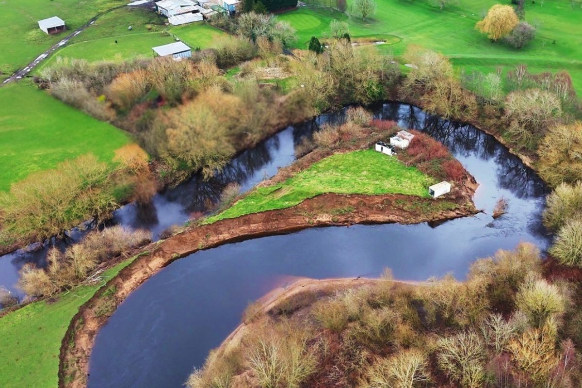
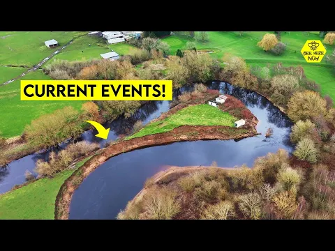
In The Wildest Stretch Of The Mersey River, Near Flixton, South Of Manchester, Erosion Advances Over A Curve So Tight That The Course May Break, Isolate An Old Bend, Form A New Island, And Even Reignite Questions About Historical Boundaries Of Local Lands And Private Properties There.
The Mersey River May Be Very Close To Creating A Visible Change In The Very Layout Between Manchester And Liverpool. In A Curvy Area That Is Little Controlled By Human Works, The Water Already Presses A Point Of Bank So Narrow That Less Than A Meter Separates The Current Flow From A Possible Natural Shortcut, Capable Of Altering The Shape Of The Channel And Transforming A Piece Of Land Into An Island.
This Possibility Draws Attention Because It Is Not A Large Engineering Project, Nor A Planned Intervention, But A Change Produced By The River’s Own Behavior. In A Scenario Marked By Fast Currents, Sediments, And Continuous Erosion, The Mersey Shows How A Watercourse That Is Still Free Can Dismantle, Alone, The Idea That Banks, Maps, And Boundaries Remain Fixed For A Long Time.
The Wild Stretch Of The Mersey That Escapes Control Between Manchester And Liverpool
The Mersey Is Described As One Of The Most Important Rivers In Great Britain, Especially Due To Its Historical Connection With Liverpool And Neighboring Areas Of The Estuary.
-
Italian researchers have detected what appears to be a second Sphinx buried under the sands of Egypt, and satellite scans reveal a gigantic underground megastructure hidden beneath the Giza Plateau for over 3,000 years.

-
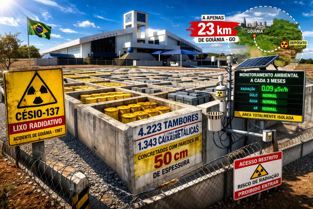
There are 4,223 drums and 1,343 metal boxes concreted with 50-centimeter walls that store the radioactive waste from Cesium-137 in the worst radiological accident in Brazil, just 23 kilometers from Goiânia, with environmental monitoring every three months.
-
Giant Roman treasure found at the bottom of Lake Neuchâtel in Switzerland reveals an advanced trade system, circulation of goods, and armed escort in the Roman Empire about two thousand years ago.

-
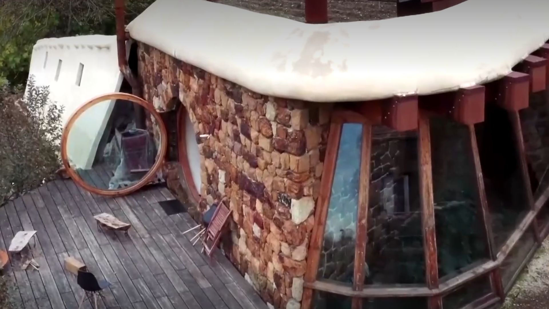
He buried 1,200 old tires in the walls to build his own self-sufficient house in the mountains with glass bottles, rainwater, and an integrated greenhouse.
Near The Sea, Its Course Is Wider And More Managed. Further Up, Between Stockport And The Ashton Mersey Area, The Banks Have Also Been Shaped By Flood Defense Works Dating Back To The 1960s. In Much Of The Course, Human Hands Have Framed The River.
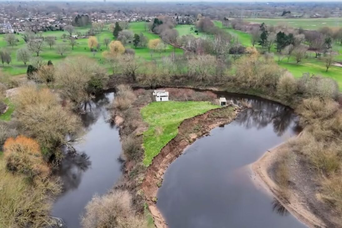
However, There Is An Interval In The Middle Of This Path Where The River Begins To Act With Much More Freedom. It Is Right There, Near Flixton, South Of Manchester, That The Mersey Meanders With More Force, Advances Over The Banks, And Draws An Instable Scenario.
This Is The Most Crucial Point In The Story Because The Future New Island Does Not Arise By Chance: It Appears Where The Course Can Still Corrode, Deposit Sediments, And Redraw The Terrain Without Being Fully Bound By Rigid Confinements.
The Area Behaves Differently From The More Controlled Extremes Between Manchester And Liverpool. The Manchester Navigation Channel, The Artificial Cuts, And The Old Interventions Show That The Mersey Has Been Widely Adjusted Over Time, But This Sector Preserves A Much Rawer Dynamic.
That Is Why The Transformation There Draws So Much Attention: It Is Not An Isolated Detail, But A Reminder That The River Can Still Impose Its Logic.
How Erosion Can Clear The Way For A New Island
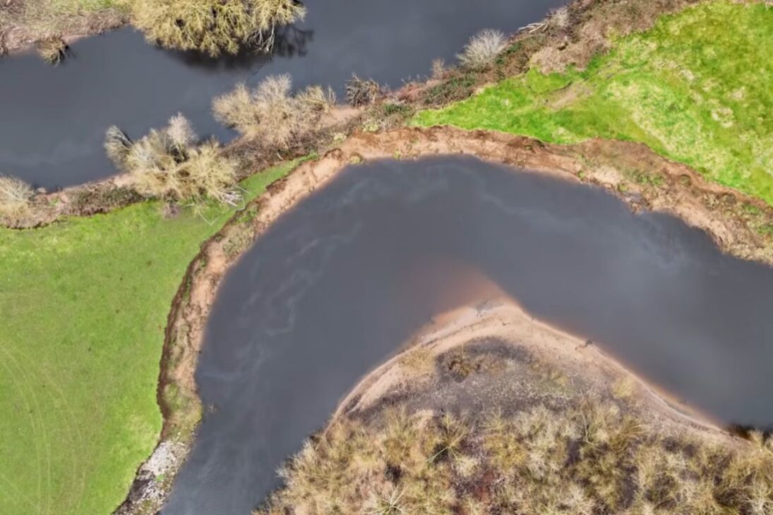
The Critical Point Is In A Broad Meander That Makes A Sharp Turn And Comes Almost Back On Itself. On The Inside Of This Curve, A Mud Bank Already Appears Very Close To The Main Flow. The Reported Distance Is Minimal, Less Than A Meter.
When A River Reaches This Level Of Proximity Between Two Sides Of Its Own Curve, The Risk Of Natural Breakage Transitions From Theory To A Concrete Possibility.
The Mechanism Is Relatively Simple. The Current, Accelerated Also By The Recent Volume Of Rain, Wears Away The Outer Bank, While The Inner Part Receives Deposits Of Silt And Other Materials. Over Time, The River Tends To Seek The Shortest Path.
If This Land Barrier Gives Way, The Water May Begin To Flow Through The New Shortcut, Widen The Opening, And Slowly Abandon The Old Curve. It Is From This Process That An Isolated Arm Usually Emerges, Known In Geography By The Pattern Of Old Horseshoe Lakes.
In The Case Of The Mersey, The Most Cautious Assessment Is That The Old Curve Is Not About To Become An Isolated Lake Immediately.
But The Formation Of A New Island Seems Much Closer. This Happens Because The Piece Of Land Surrounded By The Curve Tends To Become More And More Highlighted As The Water Finds A New Path And The Deposits Consolidate Another Bank.
What Today Appears To Be Just A Tight Curve May, In A Few Months Or A Few Years, Become A Piece Of Land Separated By The River.
Old Maps Show That The Mersey Has Changed A Lot Before This Current Point
The Historical Reading Of The Area Reinforces That This Transformation Would Not Be An Unprecedented Episode. In The 1845 Map, The Stretch Of Blakeswell Meadow Had A Very Different Design, With A More Open Shape And A Path That Passed Through Areas That Today No Longer Correspond To The Main Bed.
In Other Words, The Mersey Had Been Changing Position Long Before The Current Bank Started To Collapse Again.
Almost 60 Years Later, In 1904, The Course Still Remained Relatively Close To That Older Layout. But Another Sharp Curve Was Already Appearing In A Delicate Situation, Almost Ready To Be Cut Off. In 1954, This Inflexion Had Already Disappeared From The Main Path.
The Map From This Period Still Helps To Understand The Movement: The Line Of The Historical Boundary Followed The Older Path, While The River Was Already Pushing The Bank At Another Point And Accumulating Sediments On The Inside Of The Curve.
Seven Decades Later, The Landscape Changed Again. The Advancement Of Erosion Consumed More Land On One Side And, At The Same Time, Created Sufficient Deposits To Form A New Bank On The Other. Further Up, Towards Another Curvy Sector Of The Mersey, Curves, Sandbanks, Beaches, And Even An Old Island Surrounded By Swamp Already Appear.
The Conclusion Is Direct: The Stretch Between Manchester And Liverpool Is Not Just Moving Now, It Has Been Rearranging For A Long Time.
What Changes When A River Alters Boundaries, Ownership, And Access
This Behavior Of The Mersey Does Not Only Affect Physical Geography. It Also Creates A Practical Problem About Historical Boundaries. For Centuries, The River Has Been Treated As A Reference Between Old Counties.
When The Bed Changes, The Question Arises Immediately: Does The Boundary Follow The New Course, Remain Stuck To The Old, Or Produce A Difficult Legal Overlap? This Type Of Change Transforms A Natural Phenomenon Into A Territorial Issue.
There Is Also The Discussion About Private Property. In The Area In Question, Access Is Restricted By Fences, Barbed Wire, And Warning Signs, And The Understanding Presented Is That The Owners Control The Land Up To The Middle Of The River Bed.
The Water Would Not Be Private Property, But The Bottom Of The Canal Is. This Creates An Unusual Situation: One Owner Loses Land Due To Erosion While Another, Without Carrying Out Any Work, May Gain Land Through Natural Deposition.
The Future New Island, In This Context, Is Not Just A Landscape Event; It Also Affects Title, Boundary, And Land Value.
This Detail Makes The Story Even Stronger Because The Change Happens Precisely In An Area Of Difficult Public Access. The Landscape Is Being Redesigned In Real Time, But Most People Cannot Keep Up Closely.
The Mersey, Which Has Already Separated Lands And Helped Organize Maps, Now Challenges The Rigidity Of These Lines Again. Between Manchester And Liverpool, The New Island Emerges As A Symbol Of Something Greater: The River Continues To Remind That The Real Landscape Moves Faster Than The Version Recorded On Paper.
Why This Point Of The Mersey Draws So Much Attention Now
The Value Of This Stretch Lies In The Fact That It Is Still, To A Great Extent, A Free Segment. In A Course So Historically Shaped By Works, Finding A Sector Where The River Still Flows, Erodes, And Deposits Material Autonomously Helps To See Geography In Action Without Filters.
It Is Nature Doing What Engineering Cannot Always Prevent Forever.
Also For This Reason, The Possible New Island Sparks So Much Interest. It Does Not Represent Just A Visual Curiosity, But A Rare Moment In Which One Can Observe The Mersey Reformulating Its Own Course.
The Scenario Combines Water Speed, Bank Fragility, Cartographic Memory, And Silent Land Dispute. In Few Places Between Manchester And Liverpool Does This Mix Appear As Clearly And Concretely.
The Mersey May Not Be The Largest River In Width At This Point, But The Scale Of The Potential Change Is Huge. A Curve About To Break, A Nearly Open Natural Shortcut, A Deteriorating Bank, And A Forming Bank Are Enough To Alter The Local Map.
That Is How Transformations That Seem Small At First Can Completely Change The Reading Of An Entire Landscape.
The Possible Formation Of This New Island In The Mersey Shows That A River Is Never Just Water Flowing Between Two Banks. It Is Force, Boundary, Erosion, Deposition, And Conflict Between What Nature Moves And What Humans Try To Freeze On The Map.
Between Manchester And Liverpool, The Process Seems To Be Advancing Before Everyone, Even Though Almost No One Can See It Up Close.
In Your Opinion, Will This New Island Emerge In A Few Months, A Few Years, Or Can The Mersey Still Surprise With An Unexpected Path?


Seja o primeiro a reagir!