 Portuguese
  English
  Spanish
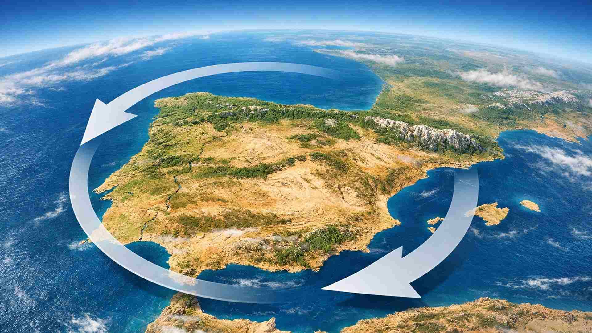
The Iberian Peninsula Is Rotating Slowly Clockwise Due to Continuous Pressure Between the African and Eurasian Plates, According to a Study Led by Researchers from the Basque Country Who Analyzed Decades of Seismic Records and Satellite Measurements, Revealing Implications for the Understanding of Regional Seismic Risk
A recent study confirms an ancient hypothesis in geology: the Iberian Peninsula rotates slowly in a clockwise direction. The change is not perceptible on a human scale, but occurs year after year, millimeter by millimeter, consistently.
The rotation is directly linked to the continuous advance of Africa towards Eurasia, especially in the complex region of Gibraltar and the Alborán Sea. There, the interaction between plates creates a scenario of distributed tension.
The research was led by Asier Madarieta-Txurruka from the University of the Basque Country, and combined two central sources of geophysical information.
-
With a cost per shot close to zero, the DragonFire laser could change naval warfare in 2027 and provide British ships with nearly unlimited defense against drones.

-
A British startup creates tires that generate electricity in electric vehicles when passing over potholes, speed bumps, and cracks.

-
Scientists have created robots made with living cells that have their own nervous system, swim on their own, explore the environment, and self-organize without any genetic engineering, and now they want to do the same with human cells.

-
Students create a solar-powered ambulance that operates without a plug, without fuel, and still keeps medical equipment running in remote areas.


On one side, decades of seismic records documenting earthquakes of different magnitudes. On the other, high-precision satellite measurements obtained from GNSS networks distributed across the Iberian Peninsula.
The intersection of these data produced a coherent panorama. It is not a spectacular or abrupt result, but a solid and revealing picture of the regional tectonic dynamics.

African Pressure and Fragmentation of the Peninsula
The key to understanding the rotation lies in the south of the Iberian Peninsula. The region does not behave as a single rigid block, but as a fragmented set subjected to uneven forces.
The African Plate advances northward at about 5 millimeters per year, pressing against Eurasia along a broad, diffuse, and structurally complex boundary marked by multiple active faults.
This irregular contact prevents the concentration of tension at a single point. Instead, pressure propagates inward into the peninsula, affecting faults distant from the coast.
Over geological time, this continuous propagation alters the geometry of the set, resulting in the slow rotation observed. It is not a direct push, but a persistent pull.
The peninsula responds like a piece caught between asymmetric forces, gradually adjusting to the stress field imposed by the relative motion of the plates.
Earthquakes as Records of Tectonic History
Earthquakes play a central role in interpreting this process. Each seismic event leaves a specific signature, known as the focal mechanism, which indicates how a fault slipped and in what direction tension acted.
By analyzing hundreds of these mechanisms, researchers identified clear patterns. Some areas show dominance of compression, while others exhibit predominant lateral slip.
These seismic patterns match surprisingly consistently with the movements detected by GNSS satellites, reinforcing the integrated interpretation of the data.
The agreement between seismic and geodetic records allows for the reconstruction of the distribution of active stresses, even where there are no recent large earthquakes.
This alignment between different methods reduces uncertainties and strengthens the conclusion that the rotation of the Iberian Peninsula is real and measurable.
What Satellite Measurements Reveal
GNSS stations are capable of detecting ground movements on the order of millimeters per year. These are imperceptible displacements, but they accumulate energy over decades or centuries.
In the Iberian Peninsula, these networks show that different blocks of the Earth’s crust move in slightly distinct directions, revealing a complex deformation field.
A central concept in this analysis is the deformation rate. It measures not only absolute displacement but how the shape of the terrain changes over time.
The direction of deformation does not always coincide with the direction of internal tension. Comparing these two parameters allows for the identification of locked areas, regions in slow fluidity, or zones with multiple modes of deformation.
In complex tectonic contexts, like that of the Iberian Peninsula, this comparison is considered invaluable for geodynamic interpretation.
Arc of Gibraltar and Dominance of Alborán
The Arc of Gibraltar plays a fundamental role as a geological buffer. East of the Strait, much of the deformation concentrates in this arc.
The crust in this region is thinner and relatively “softer,” absorbing the push of the African Plate more efficiently. Thus, part of the tension dissipates before reaching the north.
To the west, the scenario is different. The contact between the plates is more direct, allowing pressure to be transmitted to the southwest of the peninsula and to the nearby Atlantic margin.
Not coincidentally, GNSS data indicate higher rates of deformation in this area, consistent with the more direct transmission of tectonic forces.
On the edges of the Alborán domain, compression and lateral slip faults coexist, forming a tectonic cocktail that explains the diversity of observed signals.
Active Faults Beyond What Is Visible on the Surface
One of the practical contributions of the study is the identification of potential active faults without clear surface evidence. Many of these structures remain invisible on traditional maps.
The Spanish database QAFI records active faults since the Quaternary period but has significant gaps.
These gaps are more evident near Gibraltar and in parts of the Western Pyrenees, where the coverage of historical and instrumental data is limited.
The new deformation maps suggest priority areas for investigation. The study points to the need for more fieldwork, complementary geophysics, and expansion of GNSS networks.
The researchers emphasize the importance of installing additional stations, including at sea and in North Africa, to reduce regional uncertainties.
Implications for Seismic Risk
The finding of rotation raises an immediate question: does this alter the seismic risk for cities like Lisbon, Seville, or Rabat? According to the study, there is no immediate impact.
The rotation is slow, and seismic risk primarily depends on which faults are locked and the frequency with which they rupture over time.
Still, the new model refines existing maps. It reduces uncertainties, better guides risk studies, and improves the technical basis for preventive decisions.
With more realistic information, it is possible to adjust building codes and emergency plans more accurately, even without an immediate increase in threat.
In seismic prevention, details matter. Small corrections in the understanding of the stress field can yield significant gains in planning.
Low Deformation Does Not Mean Stability
The study emphasizes that calm does not equate to stability. Areas with apparent low deformation continue to record small earthquakes.
The absence of large displacements does not imply a lack of risk. In regions like the Pyrenees, processes such as erosion and continuous uplift can generate local extension.
To the south, in the Atlas Mountains, large earthquakes can occur even where the measured surface movements are minimal.
Tectonics does not always manifest noisily. In many cases, the release of stress occurs silently and distributed.
When Data Do Not Coincide
Data from seismic and satellite sources do not always coincide perfectly. In some areas, the scarcity of earthquakes complicates the interpretation of active mechanisms.
In others, the crust releases tension slowly, without sudden ruptures, which reduces the detectable seismic signal. Regions with few GNSS stations or highly fragmented geology present greater uncertainty, requiring longer time series.
The study itself avoids imposing definitive interpretations. The authors emphasize that more data and more observation time are essential.
More spatial and temporal contrast improves the ability to distinguish between locked areas and zones in continuous deformation.
Why This Rotation Matters
The importance of the rotation of the Iberian Peninsula goes beyond scientific curiosity. The landscapes inhabited today result from these slow and cumulative processes.
Ports, coastlines, mountain ranges, and sedimentary basins ultimately respond to tectonic movements like these.
The integration of seismology and geodesy allows monitoring such processes with previously unimaginable precision, providing a solid foundation for territorial planning.
This article was based on scientific research conducted by researchers from the University of the Basque Country.


Seja o primeiro a reagir!