 Portuguese
  English
  Spanish
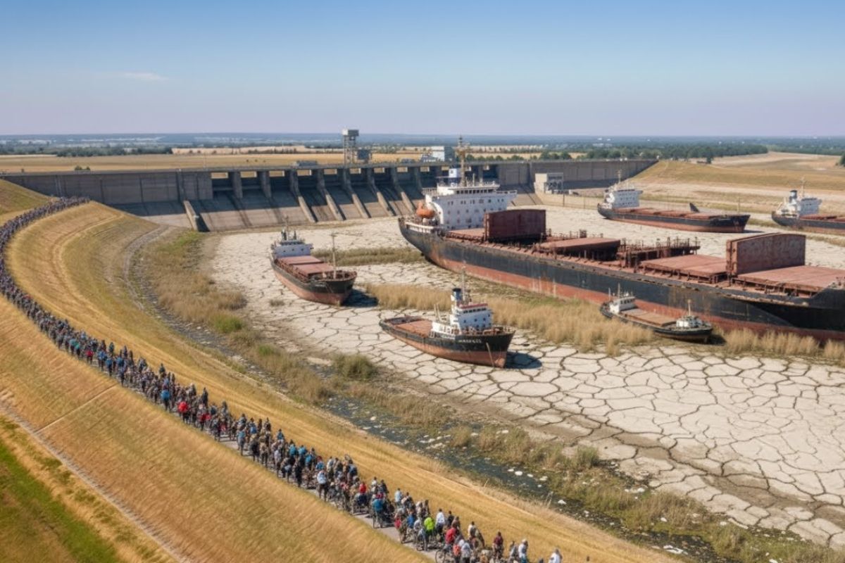
In 2013, The Danube Reached 8.91 M And Showed The Fragility Of Dikes And Dams. With More Than 80% Of The Floodplains Lost, Floods Become Faster And Higher. In The Delta, Less Sediment Makes The Coast Recede 5 To 20 M Per Year And Pressures Countries To Give Back Space.
In 2013, the Danube Rose To 8.91 M, The Highest Level Ever Recorded, And The Water Advanced With The Force Of A System Compressed By Works And Rigid Corridors. Dikes Trembled Under Pressure, Sandbags Were Hastily Piled, And Soldiers And Volunteers Worked 24 Hours A Day, Because It Would Only Take A Few Hours For An Entire City To Be Submerged.
At The Same Time, The Bill Appeared Far From The Flood Point. More Than 1,000 Km Downstream, The Danube Delta Was Described As An Ecosystem In Slow Agony, With Receding Shores, Cracking And Drying Swamps, Falling Fish, And Migratory Birds Becoming Increasingly Rare. It Was Not “Just Nature”: A Chain Of Human Decisions Along The Longest River In The European Union Pushed Risk And Fragility Into The Future.
The Shock Of 2013: When The Danube Touched The Limits Of The Defenses
The Portrait Of 2013 Is The Most Direct To Understand Why The Danube “Charged The Bill”. In A Few Days, The Water Invaded As If It Came Compressed From Afar, Running Straight To The Main Bed. The Logic Of Control Charged Its Bill: The More Rigid The Corridor, The Less The River Can Spread And Dissipate Energy When It Rises.
-
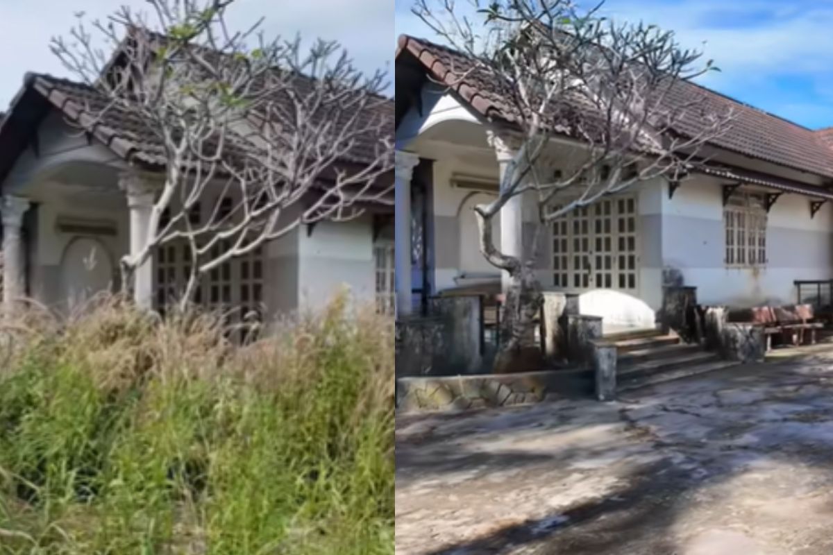
Abandoned house for 15 years disappears in the woods, shocks owner with unrecognizable scenery and is reborn in an intense transformation after almost 90 hours of work in just 10 days.
-
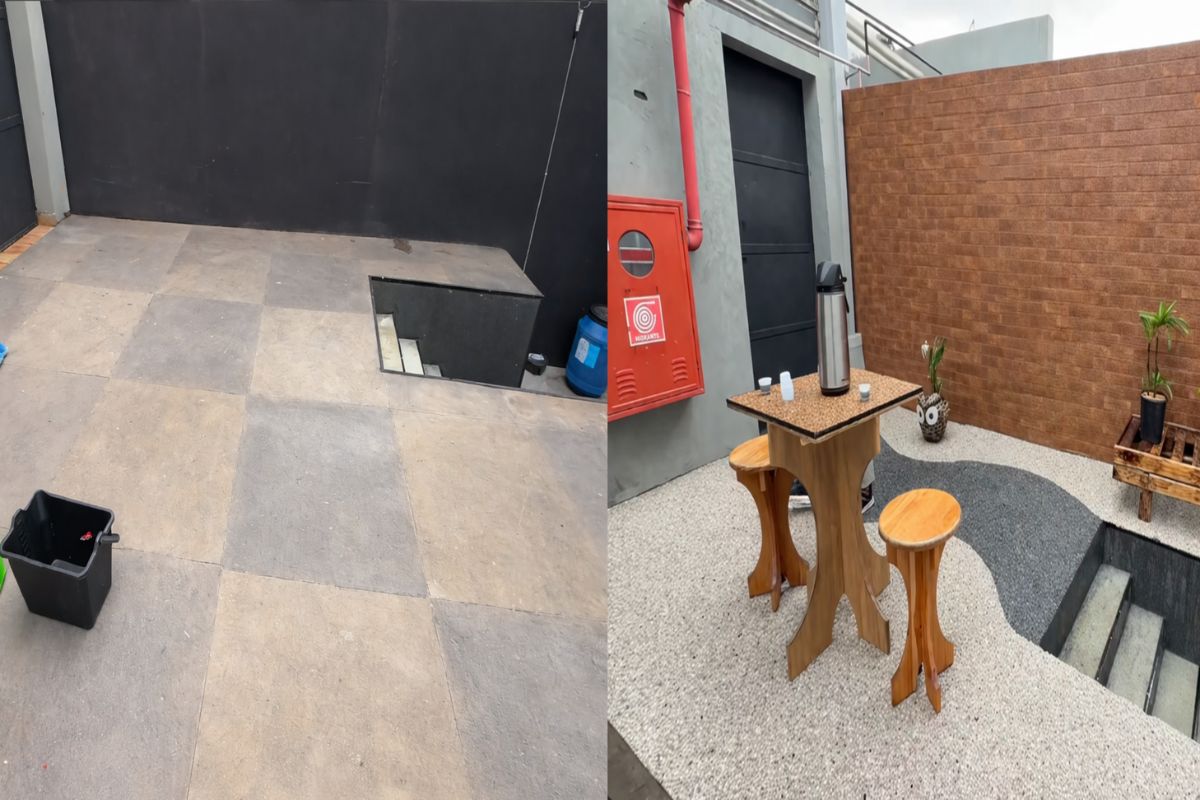
In just three hours, a natural stone floor transforms the entrance of the house with an organic effect, immediate drainage, and a sophisticated non-slip finish that doesn’t puddle water, dries quickly, and impresses with the final result.
-
‘Interlocking brick’ made of earth arrives in the construction industry with cost reductions of up to 40% on the project.

-
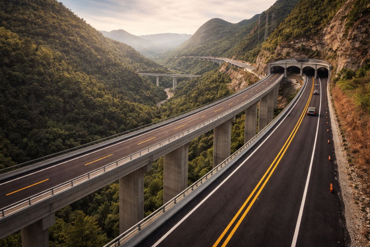
Espírito Santo will receive the largest engineering project in its history with the duplication of BR 262, which will have 50 viaducts, 28 bridges, and 2-kilometer tunnels cutting through the most challenging mountainous region of the entire state.
The Emergency Response Showed The Size Of The Bet. Tens Of Thousands Of Tons Of Sandbags Were Used As The Clock Ran Nonstop. The City Was Not Submerged, But The Pressure On The Structures Made It Clear What Hydraulic Engineers Often Harshly Summarize: Society Swapped Frequent Risk For Catastrophic Risk.
The Danube On A Continental Scale: 2,850 Km, 10 Countries And Four Capitals
Few Rivers In Europe Carry As Much Historical And Economic Weight As The Danube. With Approximately 2,850 Km, It Is The Longest River In The European Union And The Second Longest In Europe, Behind Only The Volga.
It Begins In The Black Forest Of Germany, Where Two Streams Meet, And Quickly Ceases To Be A Modest Flow To Become A Mass Of Water That Crosses 10 Countries And Cuts Through Four Capitals: Vienna, Bratislava, Budapest, And Belgrade, Before Flowing Into The Black Sea In Romania.
This Route Explains Why The Danube Has Never Been Just A River. In Ancient Rome, It Was A Military Frontier And Supply Route.
In Different Periods, It Returned To Be A Strategic Line Of Confrontation. In The Middle Ages, It Served As A Commercial Lifeline, With Goods Transported By Barges Along The Banks. Today, It Remains The Longest Inland Waterway Transport Route In Europe.
Transport, Agriculture And People: Why The Danube Affects The Entire Continent
The Danube Has Approximately 2,400 Km Suitable For Commercial Transport, Connecting Central Europe, Eastern Europe, And The Black Sea.
This Backbone Supports The So-Called Danube Corridor, Through Which Tens Of Millions Of Tons Of Grain, Coal, Ore, Oil, Chemicals, And Construction Materials Circulate Every Year.
Around This Corridor, The Danube Basin Has Supported Agriculture And Culture For Almost 2,000 Years, With Alluvial Soils Deposited By Flood Cycles.
Today, Approximately 80 To 83 Million People Live In The Danube Basin, Equivalent To The Population Of Entire Countries. Therefore, When The Danube Changes, So Do Transport Networks, Agricultural Production, Infrastructure, And Livelihoods.
The Unpredictable Nature Of The Danube And The Temptation To Intervene
The Danube Has A Large Amplitude Of Fluctuation. The Level And Volume Of Flow Vary Drastically Between Seasons And From Year To Year.
Data Cited From The International Commission For The Protection Of The Danube River Indicate That, In Central And Lower Sections, The Maximum Discharge During Floods Can Be About 20 Times Higher Than During Drought.
This Makes The Political Pressure For “Control” Predictable. Vienna, Budapest, And Belgrade Have Coexisted With Floods For Long Periods In The Past.
Only In Hungary, The Cited Estimate Points To About 21,700 Kilometers Of Land At Risk Of Flooding, Including 1.8 Million Hectares Of Agricultural Land, About One Third Of The Railway Network, 15% Of The Road Infrastructure, And More Than 2,000 Industrial Facilities. Each Major Flood Becomes A Simultaneous Shock To Agriculture, Transport, And Industry.
Floods Are Not The Only Problem: When The Danube Is Low, The Economy Stalls
The Danube Also Becomes A Bottleneck When Water Is Scarce. A Cited Report From The Danube Commission In 2022 Indicated That, Under Certain Low-Level Conditions, Up To 25% Of The Barges’ Transport Capacity Can Be Wasted.
There Is An Even More Direct Example: In A Period Of Early Drought In Hungary, Cargo Ships Were Forced To Operate With Only 30 To 40% Of Their Capacity.
When Trade Depends On Flow, An Unpredictable River Becomes A Supply Chain Risk On A Continental Scale. Technical Control Improves Some Points, But It Does Not Eliminate The Shock When The Water Disappears.
Mechanical Danger And Bottlenecks: The Sip Canal And Navigation On The Limit
Besides Floods And Droughts, The Danube Has Naturally Dangerous Sections Mechanically. In The Sip Canal, The Water Speed Can Reach Approximately 8 M/S, Faster Than A Person Running At Maximum Speed, Forcing Ships To Pass Through A Narrow Canal About 80 M Wide And Almost 2 Km Long.
For Cargo Vessels Weighing Thousands Of Tons, The Scenario Is Compared To Driving A Heavy Truck On A Steep Road, Between Two Cliffs, Without An Emergency Lane. In A Transnational Corridor, Large-Scale Intervention Has Ceased To Be Ambition And Has Become A Security Calculation.
Boundaries, Disputes And Energy: The Politics Within The Danube
The Danube Crosses Many Countries, And This Turns Upstream Water Into An Advantage, While Risks Can Be Amplified Downstream.
The Dispute Of Gabčíkovo Nagymaros Between Hungary And Slovakia Is Cited As A Classic Example: A Technical Decision About Water Diversion And Dam Construction Was Enough To Take Two Nations To The International Court Of Justice In 1997.
After World War II, Europe Also Needed Cheap, Stable, Domestically Produced Electricity For Rapid Industrialization.
Hydropower On The Danube Fit These Needs, And This Paved The Way For Decades Of Works That Changed The Logic Of The River.
How Europe “Tamed” The Danube: Straightening, Fencing, Segmenting
The Control Of The Danube Did Not Come From A Single Project. It Was A Layered Sequence Of Interventions, From The 19th Century To The Present.
The First Step Was To Straighten The Course To Accelerate Transport. Engineers Cut Hundreds Of Natural Bends To Shorten Navigation Distances. In Many Sections Of Central Europe, The Length Of The River Was Reduced By 10 To 30%.
The Gain In Speed, However, Came At A Price: The Water Began To Flow Faster And, When Floods Arrive, Peaks Come Earlier, Rise Higher, And Are Harder To Predict.
The Next Step Was To Protect Cities And Infrastructure With Rigid Embankments Along Thousands Of Kilometers. Banks Were Reinforced With Stone And Concrete To Defend River Ports, Railways, And Roads.
Previously, The Danube Could Overflow In Low Alluvial Plains And Spread Pressure. With The Rigid Corridor, The Water Was Forced To Run Within A Narrow Container.
Joint Assessments Cited From The International Commission For The Protection Of The Danube River And The World Wildlife Fund Indicate That More Than 80% Of The Danube’s Natural Floodplains Have Disappeared Compared To Their Historical State. The River Continues To Run, But Has Lost Space To Breathe When It Rises.
Dams, Reservoirs And The Danube Fragmented Into Controlled Segments
In Parallel, Europe Accelerated The Construction Of Dams And Control Structures To Maintain Navigable Depth, Generate Hydropower, And Reduce Flood Risks In Specific Sections. The Danube Was Segmented By Dozens Of Structures.
The Cumulative Effect Is Deep: Today, The Danube Is Described As Less A Continuous Flow From The Mountains To The Sea And More A Chain Of Segments, Each Functioning As A Controlled Reservoir, With Levels, Velocities, And Release Times Defined By Human Decisions.
Viewed In Isolation, Many Works Have Clear Logic And Visible Benefits.
Stacked Up, They Have Turned The Danube Into Complex Infrastructure, Forced To Carry Multiple Responsibilities At The Same Time. Infrastructure Fails When The Shock Exceeds The Design.
Iron Gates: 60 M High, 100 Km Reservoir And The Cost Of Sediment
The Most Well-Known Example Is The Iron Gates Dam, On The Border Between Romania And Serbia, Built To Turn A Historically Dangerous Stretch Into Safe Navigation. Previously, The Gorge Was A Nightmare Of Rocky Rapids, Powerful Currents, And Frequent Accidents.
The System, Largely Completed In The 1970s, Is About 60 M High And Created A Reservoir Over 100 Km Long. Rapids Became Deep, Stable Waters, Allowing Large Vessels To Pass Safely.
Besides Navigation, The Complex Supplies Electricity To Romania And Serbia, With A Combined Capacity Of Several Thousand Megawatts When Considering Iron Gates 1 And 2.
In Another Cited Reference, The Project Is Associated With More Than 2,000 Megawatts And An Approximate Generation Of 10 Terawatt Hours Per Year.
The Ecological Cost Described Is High. In Exchange For Stability And Electricity, More Than 90% Of The Sediment Remains Retained Upstream.
Migratory Fish Routes Are Blocked And Migratory Species, Such As The Danube Sturgeons, Have Virtually Disappeared From Many Sections.
Gabčíkovo: When Control Includes Diverting The Danube Into An Artificial Canal
The Second Cited Case, The Gabčíkovo Dam In Slovakia, Came Into Operation In 1992 With An Installed Capacity Of Approximately 720 Megawatts, Enough To Provide Electricity To Hundreds Of Thousands Of Families.
The Point That Makes It Unique Is The Diversion: Most Of The Flow Of The Danube Is Directed To An Artificial Canal, To Generate Energy And Maintain Stable Navigation Levels.
The Original Section Now Carries Only A Small Fraction Of The Natural Discharge. In Practice, The System Is Divided Into A Technical River In The Canal And A Severely Reduced Natural River. Levels Can Be Controlled Precisely, But The River Loses Ecological Continuity.
The Cost Of Floods: From Frequent Risk To Concentrated Risk
With Reduced Alluvial Plains And Rigidly Contained Banks, The Floods Of The Danube Cease To Spread And Begin To Concentrate Force In The Narrow Channel.
When Heavy Rain And Snowmelt Exceed Design Limits, The Peaks Come Faster, Rise Higher, And Produce More Concentrated Destruction. The 2013 Event, With 8.91 M, Is Used As A Clear Example Of How The System Can Be At A Weak Point Of Failing In A Chain Reaction.
The Social Effect Described Also Changes Over Time. Behind High Dikes, Cities And Industrial Zones Approach The River Because They Feel Safe.
When The Dike Is Surpassed, Breached, Or Undermined, The Damage Ceases To Be Just Agricultural And Spreads To Factories, Railways, And Densely Populated Areas. The Higher The Defense, The Higher The Dependence.
The Cost In The Delta: Less Sediment, Coast Receding And An Ecosystem Weakening
The Danube Delta Depends On Sediments And Natural Floods To Maintain Land, Coastline, And Biodiversity.
When Sediment Becomes Trapped By Dams Upstream, The Delta Does Not Collapse At Once. It Weakens Slowly. The Coast Recedes, Channels Become Shallower, And Agricultural Soils Lose Nutrients.
Cited Studies Indicate That The Sediment Reaching The Delta Has Decreased By More Than 50% Compared To Natural Conditions.
As A Consequence, Coastlines Recede On Average 5 To 20 M Per Year In Many Sections. The Delta Is Entering Slow Agony, With Cumulative Effects That Do Not Stop By Themselves.
The Cost In Biodiversity: Wetlands In Decline And Fish Disappearing
The Ecological Cost Is Described As The Highest. Without Floodplains, The River Loses Natural Pauses, Water Storage, And Sediment Retention, In Addition To Reducing The Capacity To Slow Down Flow.
The Decline Of Wetland Areas Along The Danube Is Described As More Than 60% Just In The 20th Century. Populations Of Aquatic Birds Have Diminished Sharply. Many Previously Common Fish Species Have Decreased By 50 To 70% In The Middle And Lower Portions.
The Control That Promised Stability Ended Up Restructuring Entire Ecosystems To An Artificial Logic.
The Final Paradox: Dams Sustain Navigation, But Extreme Droughts Derail Control
Dams Maintain Water Levels For Navigation, But Extreme Droughts Related To Climate Change Have Brought Record Low Levels In Several Years.
Ships Operate Below Capacity, Transport Costs Rise, And Supply Chains Suffer Interruptions.
The Conclusion Is Direct: Technical Control Does Not Overcome Climate Forces. At Some Point, The Reservoirs May Be Full Of Turbines And Nearly Empty Of Useful Water. The Promise Of Predictability Finds Its Limits.
The European Turn: From Absolute Control To Giving Space Back To The Danube
After Major Floods At The End Of The 20th Century And Beginning Of The 21st Century, Especially The Series Of Severe Floods Between 2002 And 2013, Countries Began To Recognize That Raising Dikes Indefinitely Only Postpones Risk. At The Same Time, Recent Droughts Exposed The Limits Of The Model.
The Response Was Not To Abandon Control, But To Admit That Engineering Alone Is Not Enough. A Cited Turning Point Is 1998, When 19 Countries In The Danube Basin Created The International Commission For The Protection Of The Danube River.
The Danube Began To Be Viewed As A Shared System, Not As A Sum Of Isolated Sections. The Objective Includes Coordinating Interests, Protecting Water Quality, And Managing Flood Risk On A Basin Scale.
Two Years Later, The European Union Adopted The Water Framework Directive, Requiring Rivers To Achieve Good Ecological Status.
The Goal For 2015 Was Not Fully Achieved, But The Common Standard Led To Old Projects Being Reexamined And Opened Space For New Concepts.
Giving Space To The River: Receded Dikes, Wetlands, And Floods In The Right Places
The Strategic Shift Appears In Initiatives To Reopen Floodplains, Restore Wetlands, And Give Space Back To The Danube.
Cited Pilot Projects In Austria, Germany, And Romania Have Repositioned Dikes Further From The Riverbed, Allowing Flood Waters To Spread Into Planned Areas, With Controlled Access.
The Philosophy Is Similar To The Approach Applied On The Rhine By The Netherlands: Accept Floods, But Only In The Right Places. Initial Cited Results Indicate Positive Signs.
The World Wildlife Fund Confirmed That Restoring Swamps Along The Danube Helps Reduce Flood Peaks And Flow Velocity, While Also Improving Habitats For Birds And Fish.
There Is Also Reference To Improvements In Water Quality In Many Sections, With Parts Of The Danube Meeting Safety Standards For Recreational Activities Such As Swimming.
Sturgeons And Connectivity: Trying To Reopen Routes Blocked By Dozens Of Dams
A Symbol Of The Restoration Effort Involves Sturgeons. They Once Swam Up The River From The Black Sea To Germany In The Middle Ages. Today, Nearly 60 Dams Have Interrupted This Route.
A Cited Plan, In Cooperation With The International Commission For The Protection Of The Danube River, Prioritizes Ecological Corridors And Fish Passage Solutions.
The Challenge Is Concrete: Former Floodplains Have Become Cities, Industrial Zones, And Railways, And Cannot Simply Be Returned By Administrative Decision.
Even So, Without Restoration, The Impacts On Floods, Droughts, And Biodiversity Tend To Be More Severe.
The Message To The World: The Shadow Of The Danube Over The Mekong
The History Of The Danube Is Also Treated As A Global Warning. Researchers See A Similar Pattern In The Mekong River, A Transboundary River That Directly And Indirectly Sustains More Than 60 Million People.
The Mekong Delta Alone Contributes Over 50% Of Vietnam’s Rice Production And Is Linked To One Of The Largest Freshwater Fisheries In The World.
In The Higher Regions, China Has Built Six Large Dams, Including Storage Projects Such As Xiaowan And Nuozhadu, Capable Of Retaining Part Of The Flow And Sediments In The Dry Season, Rapidly Altering Downstream Water Levels.
There Is Expectation Of Additional Projects, Concentrating Even More Control Upstream. Milton Osborne, A Cited Expert, Warns That Each New Storage Dam Increases The Risk Of Drought Flows Downstream, Especially When Several Operate Simultaneously.
In The Mid And Lower Course, Laos And Cambodia Are Advancing With Projects. If The Planned Ones Follow Through, The Mekong Would Be Segmented By Approximately 11 Hydroelectric Dams In The Main Channel, Turning It Into A Chain Of Connected Reservoirs.
The Critical Difference Highlighted Is Coordination: The Danube Has The International Commission And A Binding Legal Framework In The European Union, While The Mekong Still Lacks A Strong Mechanism To Balance Interests Between Countries.
The Question That Remained After A Century Of Control
The Danube Was Not Eroded By A Single Mistake. It Was Pushed To Fragility By Hundreds Of “Correct” Decisions Within National Boundaries, Political Interests, And Short Deadlines That, Added Together, Reduced The River’s Self-Regulation And Made Society More Vulnerable To Major Shocks.
Do You Think Europe Should Prioritize Giving Space Back To The Danube Even If It Requires Accepting Controlled Floods In Planned Areas?


-

-

-

-

5 pessoas reagiram a isso.