 Portuguese
  English
  Spanish
The Cold Front Advances Through Brazil, Alters Wind Circulation, Keeps Almost The Whole Country Under Alert For Heavy Rains And Strong Gusts This Monday, And Raises Concerns About Storms, Floods, And Rough Seas In The Southeast, Midwest, And Coastal Areas Of The South Throughout The Week.
The cold front advances through Brazil this Monday (9) and changes the weather behavior in almost all regions, with heavy rains, strong winds, and a risk of storms in broad areas of the country. The most delicate scenario is concentrated in the Southeast, Midwest, and South, where the combination of heat, humidity, and changes in atmospheric circulation increases the chances of disruptions.
The alert is raised because the system does not cause just isolated showers. As the cold front moves, it reorganizes the winds, increases instability, and keeps the week under watch, with the possibility of flooding, congested skies, and worsening conditions in cities already accustomed to facing impacts when the rain intensifies in a short time.
Cold Front Advances And Spreads Instability Across Almost The Whole Country
The advance of the cold front broadly changes the weather pattern and affects almost all Brazilian regions. The system favors the formation of instability areas and pushes humidity to different points in the territory, which helps explain why the alert is not restricted to a single zone on the map. The risk moves from being localized to a regional scale, especially this Monday, when the system’s movement gains more strength.
-
Scientists reveal a new method using solar light that transforms plastic into vinegar and could change the game against pollution, converting waste into a sustainable solution with future global impact.

-
3,500-year-old tear discovered reveals a textile technique much more advanced than previously thought in the Bronze Age.

-
One of the largest manufacturers of military ammunition in the world is Brazilian and has just signed an agreement with the Navy to develop national ammunition for the frigates built in Santa Catarina that will protect the Blue Amazon.

-
Scientists are baffled by hundreds of perfect circles that have emerged on the seabed in Scotland, formed by living seagrass meadows, and no one can explain whether it is nature self-organizing or something completely unknown to science.


This change also directly interferes with wind circulation. As the cold front advances, the air begins to reorganize, creating a more favorable environment for strong showers, gusts, and increased cloudiness.
It is this behavior that sustains the expectation of unstable weather throughout the week, with a sequence of days in which the sky remains more closed, and conditions become favorable for new rain episodes.
The authorities’ concern closely follows this movement. The Civil Defense advises the population to heed the alerts because the combination of large volumes of precipitation, intense winds, and saturated soil can elevate the potential for incidents, especially in urban areas and regions with more sensitive drainage.
This is not just ordinary summer rain, but a scenario in which the persistence of instability increases the risk of impact.
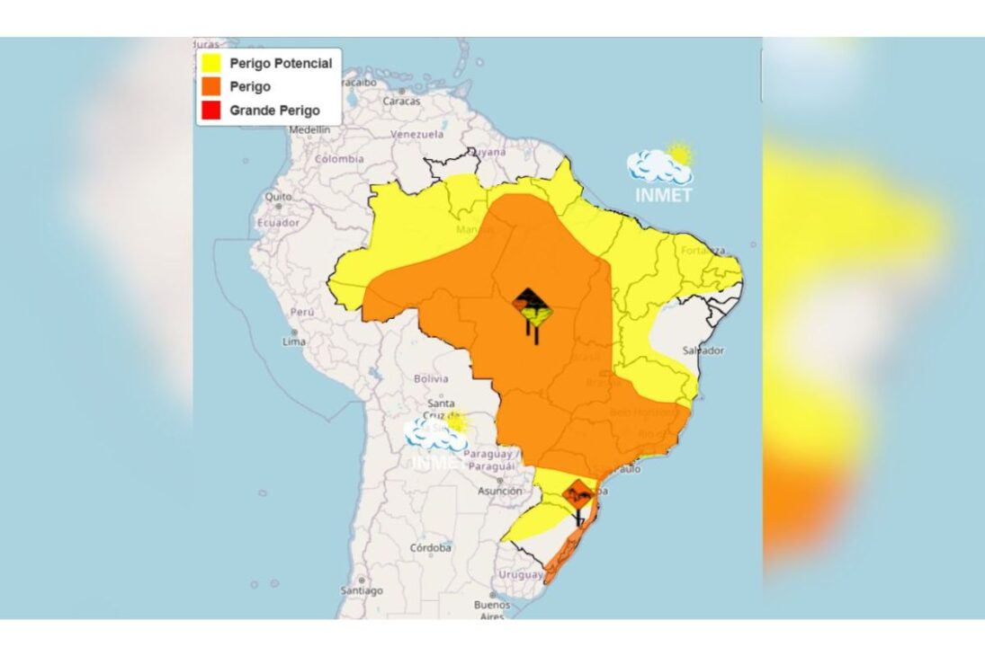
In the Inmet map, almost the entire area of the country appears under an orange alert for heavy rains and strong winds. This type of warning indicates a condition of elevated attention and reinforces that the cold front has a broad reach, affecting the pace of activities, travel in cities, and the routine of those living in areas more exposed to gusts, floods, and flood points.
Southeast Concentrates Concern About Storms, Overcast Skies, And Sudden Weather Changes
In the Southeast, the cold front more evidently alters weather patterns as it advances along the coast and influences São Paulo, Rio de Janeiro, Minas Gerais, and Espírito Santo.
The region combines ingredients that help intensify the showers: accumulated heat, high humidity, and greater formation of heavy clouds throughout the day. Therefore, the period between the afternoon and night appears as the most favorable for heavy rain and more intense episodes.
This behavior is significant because it shows that instability does not depend only on the passage of the system itself but also on the interaction with the already present conditions in the atmosphere.
When heat meets a large amount of humidity and the cold front acts as a trigger, the result is usually the formation of denser and more precipitating clouds. It is precisely in this combination that the risk of storms and floods grows in urban centers.
In the capitals, the forecast reinforces this environment of shifted weather. In Belo Horizonte, temperatures range between 18°C and 24°C. In Rio de Janeiro, the minimum is 24°C, and the maximum reaches 27°C. In São Paulo, the temperature fluctuates between 19°C and 25°C under overcast skies. These intervals show that, despite no significant drop in all locations, the presence of cloudiness and humidity already imposes a clear change in the day’s feel.
More than the numbers, what stands out in the Southeast is the persistence of the scenario. The cold front does not act as a quick and isolated event but as a system capable of sustaining instability for several days. This means that the risk is not restricted to a single shower but rather to a sequence of moments in which the rain can return with strength, requiring constant monitoring from the population and authorities.
Midwest And South Come Under Surveillance Due To Low Pressure And Intense Coastal Winds
In the Midwest, the cold front finds support in low-pressure areas, which helps maintain frequent rain in Mato Grosso do Sul, Mato Grosso, and Goiás.
In Mato Grosso do Sul, the situation requires special attention in the east and northeast of the state, mainly on the borders with São Paulo and Minas Gerais. This regional detail shows how the system also influences transitional areas, where the effects of instability tend to concentrate more intensely.
In Goiânia, the forecast indicates temperatures between 20°C and 28°C, which suggests a still relatively warm environment but already under the influence of humidity and cloudiness.
This type of configuration usually favors recurring showers throughout the day, especially when the atmosphere remains loaded and air circulation continues disorganized due to the presence of the cold front. The result is a less stable condition, more subject to rapid changes.
In the South Region, the highlight goes beyond rain and involves wind. The orange alert for intense coastal winds this Monday raises the level of attention in coastal areas, where the movement of dunes over constructions on beaches becomes a concrete concern.
Regions such as Greater Florianópolis, the Itajaí Valley, and the South Coast of São Paulo are among the most sensitive points to this weather behavior.
In Florianópolis, temperatures range between 21°C and 23°C, while Curitiba records a minimum of 17°C and a maximum of 22°C. The values confirm a more closed and cool environment in part of the South, but the central element is not just the temperature: it is the strength of the wind associated with the sea and atmospheric instability.
In coastal areas, this combination requires more caution because the cold front brings not only rain but also a circulation pattern capable of producing direct impacts on the coastal strip.
North And Northeast Follow Different Behaviors, But Also Under The Influence Of Instability
In the North, the cold front does not erase the characteristic of the Amazon rainy season but adds to an environment that already favors frequent precipitation.
Amazonas, Pará, Acre, and Rondônia continue under the influence of recurring rains, within a pattern where high humidity and regional dynamics keep the weather heavier. In this case, the system helps reinforce a scenario that is already naturally more prone to rain occurrence at this time.
This means that instability in the region does not need to manifest in the same way as in the Southeast or South to warrant attention.
In the North, rainfall behavior tends to be more constant, and the presence of a larger scale system like the cold front may help keep the weather overcast and increase the frequency of rain episodes. The impact is less in surprise and more in the persistence of the humid pattern.
In the Northeast, the situation is more irregular. Part of the northeastern east remains stable, while the interior records isolated showers. This regional difference shows that the cold front’s influence is not distributed evenly across the country. Even when the system advances forcefully in various areas, it encounters distinct responses according to geographic position, available humidity, and local wind circulation.
This irregularity helps explain why some areas may go through the week with more frequent rain, while others feel only an increase in cloudiness or occasional weather changes. Still, the advance of the cold front keeps the country under a general pattern of greater meteorological attention, as the atmosphere remains sensitive and subject to rapid changes in different regions.
The Week Begins With An Alert And Tends To Continue Under Instable Weather
What marks this Monday is not only the passage of the cold front but the way it inaugurates a week of prolonged instability.
The movement of the system alters wind circulation, favors the formation of heavy clouds, and maintains an environment conducive to new episodes of heavy rain in several parts of the country. The weather turns for good and shows no immediate signs of reprieve.
In practice, this means that following the alerts becomes essential, especially in cities where the historical context of floods, flash floods, and disruption from winds tends to weigh when the rain intensifies.
The scenario requires attention both from those living in dense urban areas and from those near the coast or in regions more exposed to the action of the winds. The cold front does not hit every place in the same way but raises the risk level over a vast range of the national territory.
The most important reading at the moment is that instability ceases to be an isolated event and becomes part of the routine for the coming days. Between heavy rain, overcast skies, gusts, and temperature variations, the week begins with a clear signal of change in climate behavior. And, when this type of system is established, prevention becomes as important as prediction.
In your city, has the cold front already changed the weather this Monday? Did you experience heavy rain, strong winds, or flooding near you? Share in the comments how the situation is in your area and if the alert has already affected your routine.


-

-

2 pessoas reagiram a isso.