 Portuguese
  English
  Spanish
 Lost continent 155 million years ago tracked by geologists reveals fragments scattered across Southeast Asia in a discovery that redefines tectonics.
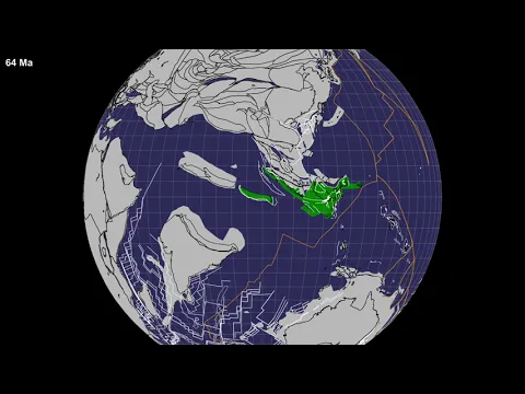
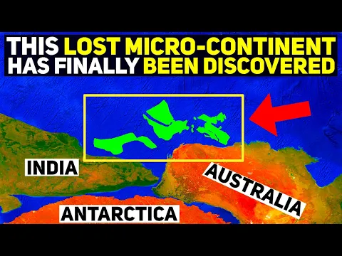
In 2023, a team of geologists from Utrecht University in the Netherlands announced a discovery that helped solve one of the greatest enigmas of modern geology: the fate of Argoland, a continental mass that separated from the northwest of Australia about 155 million years ago during the fragmentation of Gondwana. According to Utrecht University itself, in a statement about the study later published in the journal Gondwana Research, the so-called “lost continent” did not simply sink into the ocean, as had been believed for decades.
The most impactful data is that Argoland did not disappear as a single block, but was formed by multiple continental fragments separated by older ocean basins, now identified in different parts of Southeast Asia. The discovery was made possible by crossing marine magnetic anomalies, tectonic reconstructions, and analysis of regional geological architecture, allowing the reconstruction of a territory that ceased to exist as a continental unit but never completely disappeared.
What was Argoland and how did it separate from Australia
Argoland was a continental mass that was part of the ancient supercontinent Gondwana, which included areas that today correspond to South America, Africa, Antarctica, India, and Australia.
-
Scientists have captured something never seen in space: newly born stars are creating gigantic rings of light a thousand times larger than the distance between the Earth and the Sun, and this changes everything we knew about stellar birth.

-
Samsung launches cordless vertical vacuum cleaner with up to 400W of suction and relies on AI to automatically recognize corners, carpets, and different surfaces.

-
The lost continent beneath Europe: separated from North Africa about 240 million years ago, comparable in size to Greenland, Greater Adria was crushed over 40 million years and left geological marks from the Alps to the Balkans.

-
A cold front advances through the South this Saturday and reaches the Southeast on Easter Sunday with heavy rain and a drop in temperature, while the North and Northeast face the risk of storms and flooding throughout the holiday.


During the Jurassic period, about 155 million years ago, tectonic forces began to fragment this gigantic landmass. In this process, Argoland detached from the region that today corresponds to the northwest of Australia.
Unlike other continental fragments that maintained their integrity, Argoland underwent a much more chaotic process, being subjected to intense tectonic activity, collisions, and deformations over millions of years. This complexity was precisely what made its identification so difficult for so long.
Why scientists believed the continent had disappeared
For decades, geologists had indirect evidence that a continental block had separated from Australia. This evidence mainly came from gaps in the reconstruction of tectonic plates.
However, there was no “clear fate” for this continental mass, which led many researchers to suggest that it might have been completely subducted, that is, swallowed by the Earth’s mantle.
This type of total disappearance is extremely rare for continental crust, which is less dense and tends to resist the subduction process.
This inconsistency led to one of the biggest questions in modern geology: how could an entire continent simply disappear?
The discovery that changed the understanding of lost continents
The team from Utrecht University used a different approach to solve the problem. Instead of searching for a single intact continental block, the researchers began to analyze fragmented regions of Southeast Asia.
Combining:
- paleomagnetic data
- tectonic plate reconstructions
- analysis of continental rocks
- geodynamic modeling
the scientists were able to identify that parts of Argoland were scattered across a vast region that includes areas of Indonesia, Myanmar, and other zones of Southeast Asia.
What seemed to be an absence of evidence was, in fact, an excess of fragmentation, with pieces of the continent distributed and deformed over millions of years.
Extreme fragmentation created an “invisible continent”
What makes Argoland unique is the degree of fragmentation it underwent. Instead of forming a continuous block, as happened with India, which moved intact until colliding with Asia, Argoland was divided into multiple smaller fragments.
These fragments were incorporated into different tectonic plates, pushed, folded, and redistributed over time, making it practically impossible to recognize them as part of a single origin.
This process created what scientists describe as an “invisible continent,” not because it disappeared, but because it lost its geographical identity.
The role of plate tectonics in the destruction of Argoland
The plate tectonics is the fundamental mechanism behind this transformation. After separating from Australia, Argoland entered a zone of intense tectonic activity, where oceanic and continental plates interact in a complex manner.
These interactions include collisions, partial subduction, rifting, and structural deformations, which over millions of years completely fragmented the original mass.
Moreover, the Southeast Asian region is one of the most geologically active on the planet, with multiple plates in constant interaction, which contributed to the dispersion of the fragments.
How scientists managed to reconstruct this puzzle
The reconstruction of Argoland required work comparable to assembling a puzzle without a visual reference. Researchers analyzed characteristics such as:
- age of the rocks
- mineral composition
- ancient magnetic orientation
- relative position of the plates over time

This data allowed for connections to be drawn between regions now distant, revealing that they were part of the same continental structure in the past.
This type of analysis only became possible with advances in geological modeling techniques and access to large global databases.
Scientific implications of the discovery of Argoland
The discovery of Argoland is not just a geological curiosity, but has profound implications for science.
It shows that: continents do not need to remain intact to be traced, and that processes of extreme fragmentation can completely obscure their existence for millions of years.
Moreover, the discovery helps refine models of:
- movement of tectonic plates
- formation of mountain ranges
- evolution of oceans
It also contributes to the understanding of how natural resources, such as minerals and hydrocarbons, may be distributed in complex regions.
Southeast Asia as a mosaic of ancient worlds
The region where the fragments of Argoland were identified was already known for its geological complexity.
However, the discovery reinforces the idea that Southeast Asia is, in practice, a mosaic of multiple continental fragments, coming from different parts of the planet. This explains why the region exhibits:
- great geological diversity
- intense seismic activity
- complex mountain formations
Each fragment carries its own story, now connected to a common past.
A continent that did not disappear, but was transformed
Contrary to the initial idea, Argoland was not completely destroyed. It continues to exist, but in a completely different form, distributed in fragments that today are part of other geological structures.

This change in perspective alters the way scientists interpret the evolution of the Earth’s crust. The discovery of Argoland shows that the Earth still holds hidden records of its own history, many of them invisible at first glance.
By revealing that an entire continent can be fragmented and “hidden” over millions of years, the study broadens the understanding of the planet’s dynamics and demonstrates that there are still great geological enigmas to be solved.
More than a lost continent, Argoland represents a new way of understanding how the planet continuously transforms, rearranging its structures on timescales that exceed human existence itself.


Seja o primeiro a reagir!