 Portuguese
  English
  Spanish
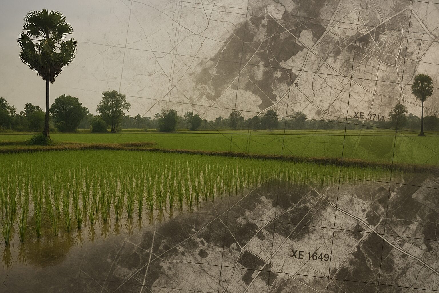
Declassified Images And Artificial Intelligence Reveal Bomb Sites Buried For Decades, Accelerating Efforts To Save Lives And Recover Farmland In Southeast Asia
In the rice fields of Cambodia and the forests of Vietnam, dangers from the past continue to lurk. Decades after the end of armed conflicts, bombs and landmines still affect thousands of lives.
Now, a union between technology and historical memory is beginning to reveal where these explosives remain hidden.
Markings Of A War That Has Not Ended
Between the late 1960s and 1990, Cambodia experienced a long civil war. It is estimated that around ten million mines and explosives were spread throughout the country.
-
While the world looks at oil, the war with Iran is already disrupting helium supply from Qatar, affecting car and iPhone chips, threatening AI expansion, and putting pressure on aluminum packaging at the highest value in four years.

-
Global warming will expose a treasure hidden under the ice of Antarctica and may spark an international dispute over gold and valuable minerals.

-
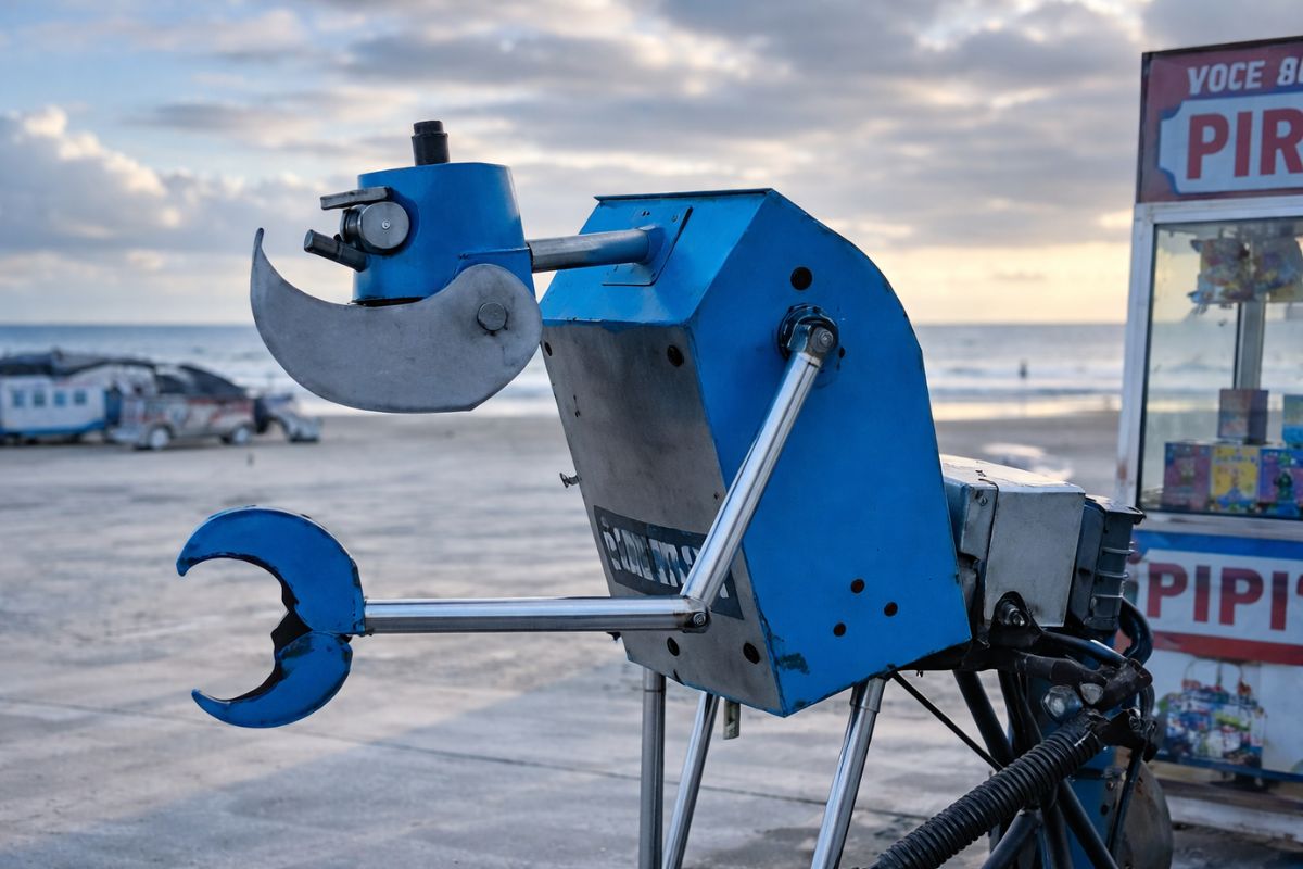
A street vendor from Praia Grande built a robot made of scrap from scooters and washing machines that pulls his popcorn cart on the beach, emits sounds, and interacts with customers, becoming an attraction on the coast of São Paulo.
-
The specifications of the Xiaomi 18 Pro Max have been leaked, and the highlight is a dual 200 MP camera with a new 22-nanometer technology that promises to consume less energy and capture details in shadows and bright areas using LOFIC HDR.


Most remain active, even after the official end of the conflict in 1998. Since then, over 20,000 people have died in landmine incidents. Another 45,000 have been injured.
According to Tobias Hewitt, national director of the NGO HALO Trust in Cambodia, more than 50 accidents are still reported each year. “The number is decreasing steadily, but it’s still a huge problem”, he told Space.com.
Vietnam is in a similar situation. During the Vietnam War, the United States dropped millions of tons of bombs on the country.
Many did not explode, especially in agricultural areas. The moist, soft soil cushioned the impacts but did not prevent the threat.
“The most fertile land is also the most dangerous”, explained Erin Lin, a political scientist at Ohio State University. Farmers continue to work these lands because they depend on them. “If we don’t do this, we won’t be able to survive”, said Hoàng Thi Mai Chi, manager of the Mine Advisory Group in Vietnam.
Space Photos Reveal Clues To The Danger
For years, the work of locating mines was done with metal detectors, in long and imprecise processes. That began to change in 2011, when the US declassified images from the Cold War-era HEXAGON spy satellites.
These images show the terrain as it was in past decades. “We were able to overlay these images onto Google Earth and identify old roads”, Hewitt recounted.
These roads are important clues. Troops in retreat often placed mines along them. However, many routes have disappeared under vegetation or crops.
“Not knowing there was a road there, people think it’s just common land and cultivate it”, Hewitt said. This, unfortunately, leads to accidents.
With the help of the images, HALO Trust has already mapped thousands of suspected locations in western Cambodia. Even so, each area needs to be personally investigated.
The process involves aligning old images with modern maps and analyzing everything step by step.
Artificial Intelligence Enters The War Against Mines
Meanwhile, in Vietnam, data scientist Philipp Barthelme began studying declassified CIA images during the pandemic.
He trained an artificial intelligence (AI) model to identify bomb craters. His goal: to predict where bombs may have fallen but did not explode.
“The simplest thing is to detect the craters. The challenge is to understand how this can help the work of demining NGOs,” Barthelme said. His project turned into a doctorate at the University of Edinburgh.
However, there are limits. Large bombs create visible craters. Smaller munitions, like fragmentation rounds, do not leave easy-to-identify marks.
Another advance came with DeskAId, an AI tool developed by the International Committee of the Red Cross.
Created by Martin Jebens and his team, the system uses historical data and satellite images to predict areas with mines. It analyzes the proximity of roads, buildings, and hospitals—common places of past conflicts.
The system, currently testing in Cambodia, has achieved up to 92% accuracy. Despite the good results, the creators warn: only humans can confirm what machines suggest.
“There is enormous potential for saving time, money, and, most importantly, lives”, Andro Mathewson told New Scientist.
Limits Of Resources And Challenges On The Ground
Despite the advances, the work still faces obstacles. Cambodia has already cleared more than 3,200 km² of contaminated areas.
However, about 470 km² remain. In Vietnam, the exact extent is still unknown. Many affected areas are mountainous and isolated, requiring lengthy journeys.
During Donald Trump’s second term, the United States suspended external funding for bomb removal for over a month. For programs that rely on that funding, the pause was concerning.
Seán Moorhouse, an explosives consultant, questions the US role. “There is a moral obligation, as it was they who dropped the bombs. Any cut in funding would be disastrous for Vietnam”, he said.
Living Memories And Hope For The Future
Today, Hoàng Thi Mai Chi continues to help farming families in Vietnam. She witnessed the horrors of the war up close when she was still a child. Now, she dedicates her life to preventing others from going through the same.
“Even my children today ask about the war,” she shared. “But we have to move forward. We work with different countries, not just the United States, to rebuild Vietnam.”
For these communities, peace does not just mean the end of gunfire. It means recovering the land, step by step, from a past that insists on staying buried.


Seja o primeiro a reagir!