 Portuguese
  English
  Spanish
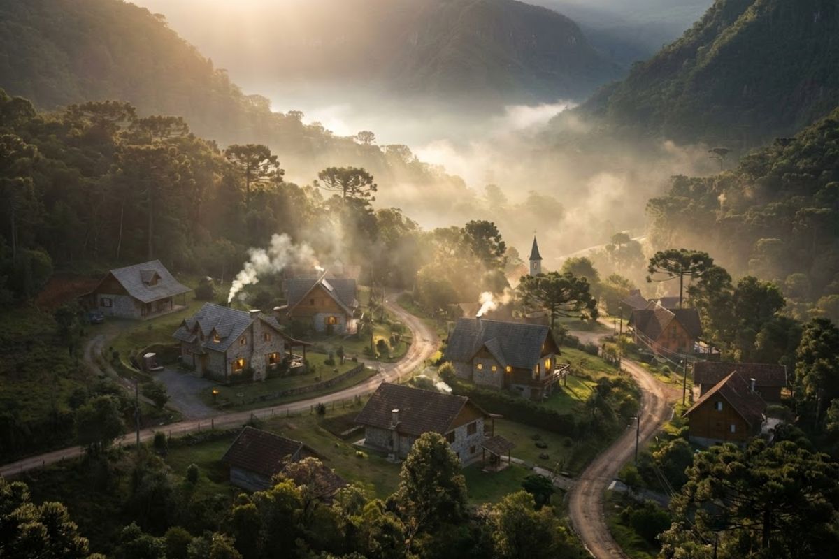


Located 190 km from Porto Alegre, the gaucho city of Cambará do Sul has become a base for visiting Aparados da Serra National Park and the Itaimbezinho and Fortaleza canyons. With 1,212 km² and founded on December 20, 1963, it maintains a temperate climate, occasional frosts, and snow in the winter.
How the gaucho city of Cambará do Sul, with 6,361 inhabitants, has established itself as a starting point for the gorges of southern Brazil and as a mountain refuge at an altitude of about 1,000 meters, located 190 km from Porto Alegre.
The text also recalls the founding date of Cambará do Sul, on December 20, 1963, and relates local daily life to ecotourism and cattle ranching, focusing on safety, tranquility, and small-town routines, along with direct access to Aparados da Serra National Park, Itaimbezinho Canyon, and Fortaleza Canyon.
Technical Portrait of the Gaucho City and the Numbers That Explain the Destination

Cambará do Sul is presented as a gaucho city with a low population density, with 6,361 residents according to the cited official census, in a territory of 1,212 km².
-
Italian researchers have detected what appears to be a second Sphinx buried under the sands of Egypt, and satellite scans reveal a gigantic underground megastructure hidden beneath the Giza Plateau for over 3,000 years.

-
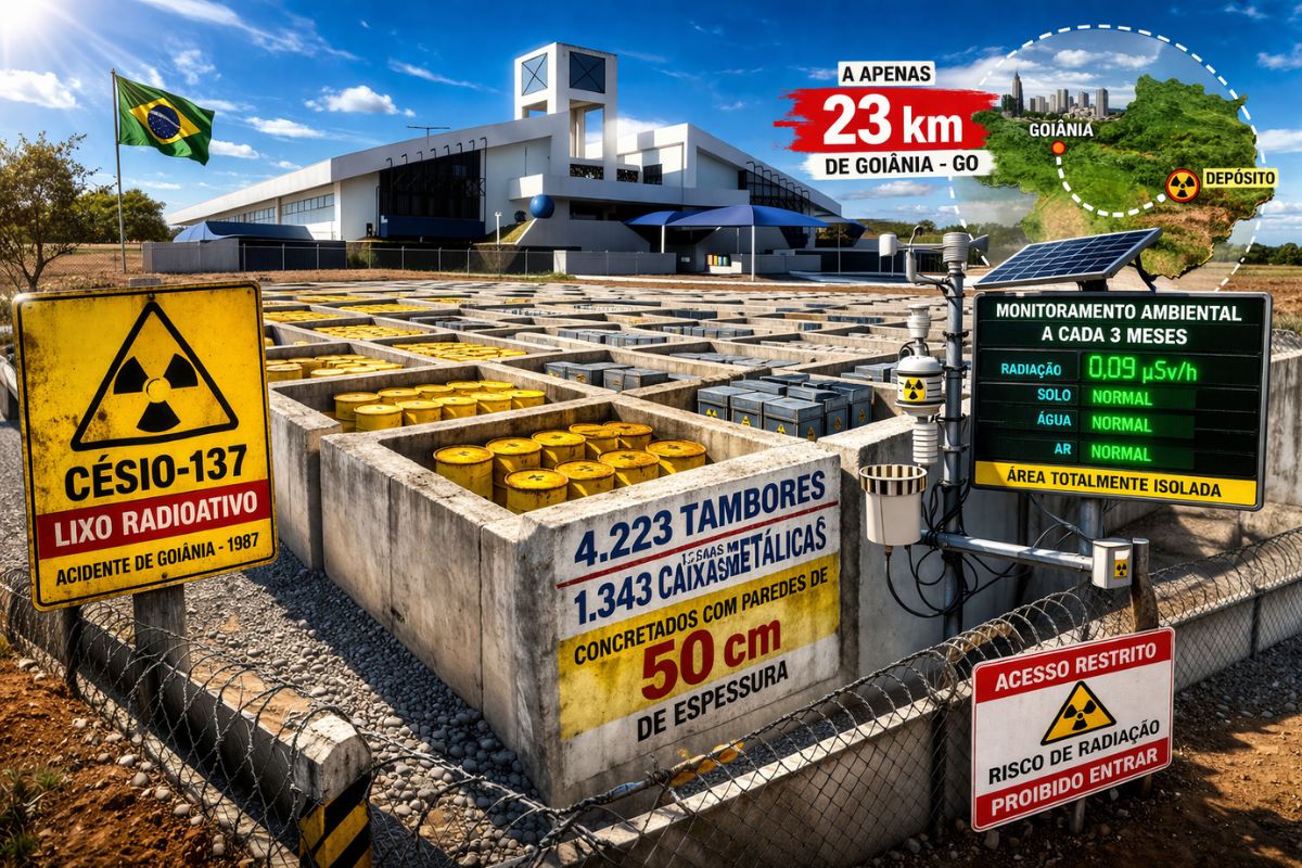
There are 4,223 drums and 1,343 metal boxes concreted with 50-centimeter walls that store the radioactive waste from Cesium-137 in the worst radiological accident in Brazil, just 23 kilometers from Goiânia, with environmental monitoring every three months.
-
Giant Roman treasure found at the bottom of Lake Neuchâtel in Switzerland reveals an advanced trade system, circulation of goods, and armed escort in the Roman Empire about two thousand years ago.

-
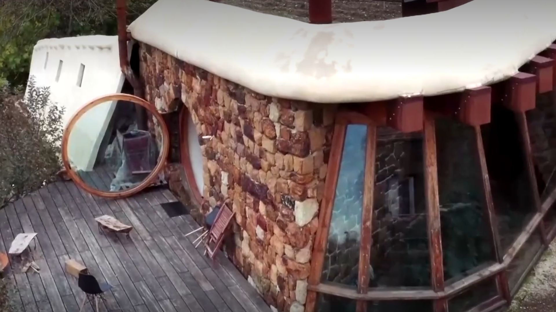
He buried 1,200 old tires in the walls to build his own self-sufficient house in the mountains with glass bottles, rainwater, and an integrated greenhouse.

These two numbers help to size what the visitor finds: a compact urban area and large fields in the surrounding mountainous region.
The official founding on December 20, 1963 appears as the administrative mark of the municipality.
In practical terms, the gaucho city is described as a logistics base for visits to the canyons and as the gateway to Aparados da Serra National Park, where the most popular viewpoints and trails are concentrated.
The distance of 190 km from Porto Alegre is used as operational data for those traveling by road.
In weekend planning, this radius positions Cambará do Sul as a viable option for terrestrial travel, provided the itinerary includes an overnight stay to reduce timing pressure.
Altitude, Ventilation, and the Cold Standard That Defines Cambará do Sul

The gaucho city is described with an average altitude of approximately 1,000 meters, constant ventilation, and a temperate climate.
This climatic set sustains the image of a mountain refuge and explains the recurrence of frosts.
Winter is presented as rigorous, with frost and occasional episodes of snow, phenomena that alter landscapes, visibility, and even travel routines.
The base also lists average temperature ranges by season, as a reference for planning, treated as approximate values:
Summer: 15°C to 25°C
Autumn: 10°C to 20°C
Winter: -5°C to 15°C
Spring: 12°C to 22°C
In terms of route management, the central point is the temperature range.
At canyon edges, wind and fog can reduce thermal sensation and shorten useful time at viewpoints, especially on frosty days.
Aparados da Serra as an Attraction Axis and the Function of the Gaucho City Base
Aparados da Serra National Park appears as a territorial anchor for tourism, and Cambará do Sul is described as the main starting point for the region’s gorges.
This defines an objective function: lodging, dining, guides, and short trips to access points.
The same logic applies to the set of canyons.
The Itaimbezinho Canyon and the Fortaleza Canyon are mentioned as central routes, and the gaucho city functions as a base for departure and return, especially for those wishing to visit early and reduce the risk of low visibility.
When the text refers to “Land of the Canyons,” it describes a regional positioning associated with ecotourism and the typical hospitality of the upper mountain fields.
In operational language, this means services oriented towards trails, contemplation, and travel on mountain roads, focusing on a slower pace.
Access by Highway: RS-020, BR-101, and the Route of the Sun
To reach Cambará do Sul, the base describes road access via RS-020 or BR-101 through the Route of the Sun.
The central point here is connectivity: the gaucho city is portrayed as interconnected to the main tourist destinations of Rio Grande do Sul by marked roads.
These routes matter for two reasons. First, they condition the total time from Porto Alegre and other cities.
Second, they determine predictability in cold periods when frost can reduce grip and require caution in mountain sections.
In planning, the most objective data remains the radius of 190 km in relation to Porto Alegre, useful for estimating travel windows during holidays and the high winter season.
Priority Routes: Itaimbezinho Canyon, Fortaleza Canyon, and Cachoeira dos Venâncios
The listed itinerary includes four recurring points:
Itaimbezinho Canyon
Fortaleza Canyon
Cachoeira dos Venâncios
Aparados da Serra National Park
The presence of Itaimbezinho Canyon and Fortaleza Canyon in the same package indicates that the gaucho city functions as a visitation hub.
In practice, those who sleep in Cambará do Sul can divide the canyons across different days, with planned trips and return to the urban center.
Cachoeira dos Venâncios broadens the scope and reinforces that the municipality is not limited to the gorges.
Still, Aparados da Serra remains the element of greatest symbolic density, as it concentrates geological formations and edges that define the landscape.
Living in the Gaucho City: Safety, Routine, and Economy Anchored in Ecotourism
In addition to tourism, the base describes advantages of residing in the mountainous region.
The gaucho city appears as an environment of safety and tranquility, with urban stewardship and a community fabric of closer ties among residents.
The local economy is presented as driven by ecotourism and cattle ranching, with opportunities in the hospitality sector for new residents and ventures related to visitation, lodging, and dining.
Here, the technical point is that the local market tends to be seasonal, with peaks in cold weather and during vacation windows, which requires cash and team planning.
The pure air of the mountains is cited as a factor for well-being.
In objective terms, this translates into less urban density, less noise, and a routine that depends more on the weather than on strict schedules, a typical characteristic of small-town life in a high-altitude environment.
Education and Services: What the Base Informs About Local Structure
In the educational field, the text mentions the State School of Basic Education Neusa Goulart Brizola as a pedagogical reference in the state public network.
In small municipalities, this type of reference is significant as it signals a hub of regular attendance within the territory.
It is also mentioned that proximity to larger centers allows access to higher education institutions in neighboring regional hubs.
This information appears as a logistical advantage, without detailing distances and specific cities, which limits comparisons but records regional integration.
How to Visit Without Improvisation: Hours, Weather, and Itinerary Organization
In practice, the itinerary in Cambará do Sul tends to be defined by three variables: weather, visibility, and travel time between points.
On frost days, the temperature may approach the minimum winter range cited, which alters clothing, hydration, and time spent at viewpoints.
The operational guidance derived from the base is straightforward: leave early for Aparados da Serra National Park, prioritize Itaimbezinho Canyon one day and Fortaleza Canyon another, and keep an alternative like Cachoeira dos Venâncios in case wind and fog reduce visibility at the canyon tops.
Since the gaucho city is 190 km from Porto Alegre, the choice between a day trip and an overnight stay affects the quality of the itinerary.
With an overnight stay, visitors reduce the risk of traveling at critical times and increase the chance of clear skies.
Cited Experiences: Sunrise in the Canyons, Artisan Honey, and Mountain Fields
The base lists contemplative experiences and local culture. Three examples appear as opportunities to complete the visit:
Enjoying the sunrise at the edges of the canyons near the Centro neighborhood
Tasting the artisan honey produced on the rural farms of the mountainous region
Exploring adventure routes in utility vehicles across the mountain fields
These items help explain why the gaucho city has become a silent mountain refuge.
The focus is not on intense urban attractions but rather on landscape, pace, and controlled movement between nature and local structure, with Aparados da Serra and Itaimbezinho Canyon as central references of the itinerary.
With 6,361 residents, an average altitude of 1,000 meters, and serving as the base for Aparados da Serra, Cambará do Sul stands out as a strategic gaucho city for seeing Itaimbezinho Canyon and Fortaleza Canyon with a realistic itinerary.
The operational data is simple: 190 km from Porto Alegre, the destination works when the planning respects weather, road, and viewpoint timing.
If your schedule allows, plan for at least two nights, prioritize early departures, and note at what times fog appears and dissipates.
This control enhances the experience and prevents the gaucho city from being reduced to a rushed visit.
Do you think that the gaucho city of Cambará do Sul is already prepared to grow with ecotourism without losing the silence and safety that attract visitors?


Os parques são de belezas inimagináveis, mas valores cobrados pela administracao dos parques (107,00 por pessoa + 20,00 pelo estacionamento) afugentam qualquer familia, escolhendo outro roteiro na escolha de passeios ….
O fluxo turístico na cidade e consequentemente sua economia despencaram após a Urbia assumir o controle dos parques e seus cânions, cobrando valores exorbitantes que afugentaram a visitação. Os serviços oferecidos não compensaram tal declínio, e a empresa se mantém intransigente ao diálogo com a população prejudicada. Injustificável, irrázoavel, lamentável…
Quero dar uma posição atual. Os parques Aparados da Serra ( onde está o cânion Itaimbezinho) e da Serra Geral ( onde está o canyon Fortaleza) agora são gerenciados pela empresa Urbia, que melhorou a infraestrutura significativamente nos parques. A estrada para o cânion Fortaleza é asfaltada e para o cânion Itaimbezinho está sendo asfaltada. Cambará do Sul não é somente cânions a se visitar, temos várias cachoeiras de águas límpidas e geladas, vários lageados, campos e colinas verdejantes fantásticas. Venha ver com seu próprios olhos.