 Portuguese
  English
  Spanish
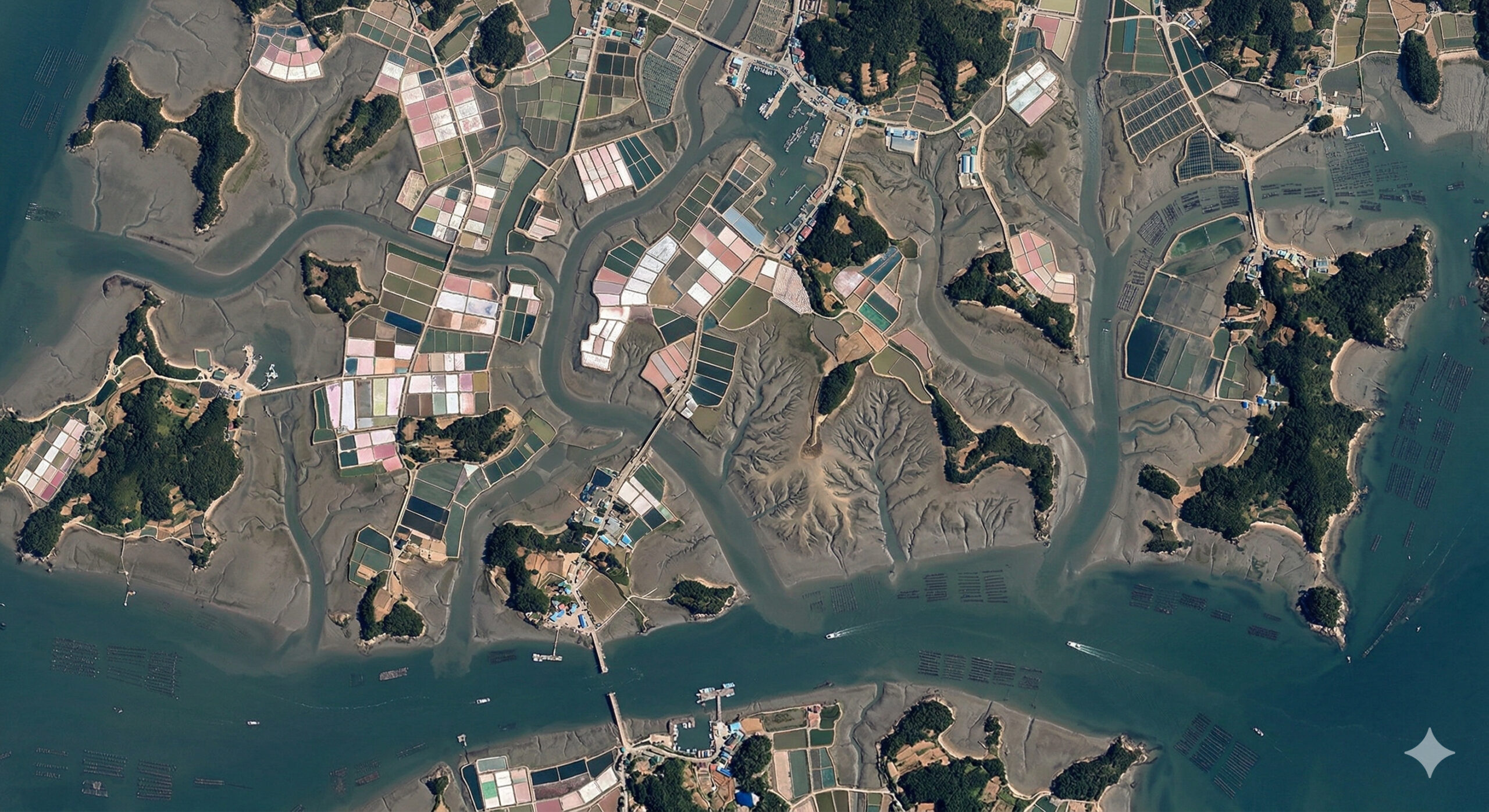
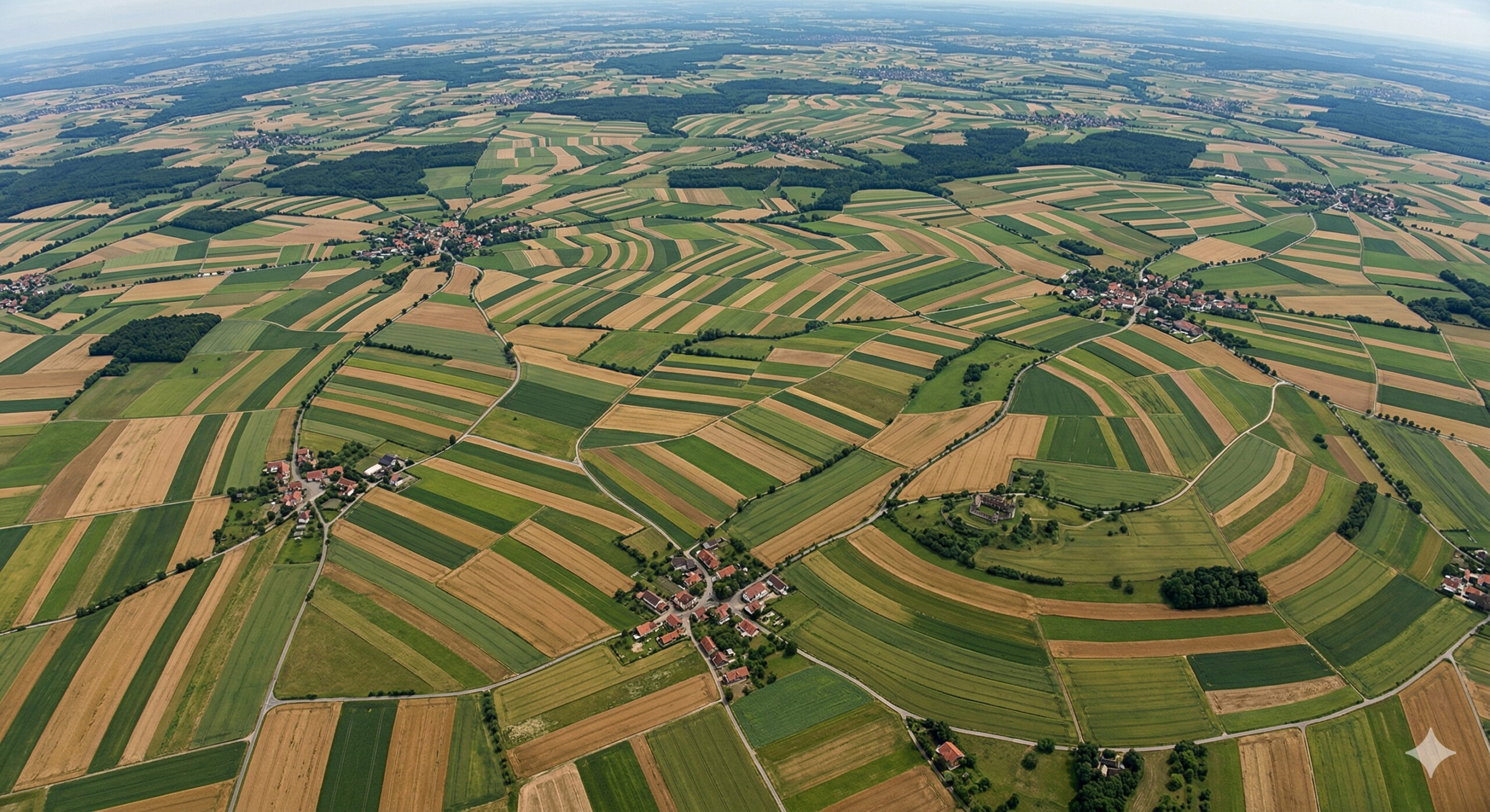
Satellite images show in southern South Korea a mosaic of islands and salinas that transforms the coast into one of the most unusual patterns visible from space.
In records analyzed by the NASA Earth Observatory, the southwestern region of South Korea appears as one of the most visually complex coastal landscapes when viewed from space. Along the coastline of Jeollanam-do province, especially in areas near the Sinan archipelago, more than 1,000 islands, mudflats, salinas, and human structures form an extremely fragmented mosaic, creating a design that resembles an irregular puzzle scattered between the sea and land. According to an analysis published on the official NASA Earth Observatory portal, Sinan County accounts for about one quarter of all the islands in South Korea, most surrounded by extensive shallow tidal flats that are sometimes submerged and sometimes exposed depending on the tides.
What differentiates this region from other coastal areas is precisely the intensity of this fragmentation. It is not just a collection of natural islands, but a continuous interaction between coastal geography, tides, and human intervention, which over time has shaped a hybrid territory. NASA itself highlights that the region’s tidal flats are highly productive ecosystems and that part of these reclaimed areas has been used for commercial salt production, with reservoirs and evaporation ponds visible in orbital images as checkered fields.
When viewed from space, this landscape takes on a completely different dimension, revealing patterns that are not perceptible from ground level. The images show a constant alternation between flooded areas, strips of land, channels, and artificial surfaces, creating a visual composition that seems planned but actually results from the combination of natural processes and centuries of human occupation along the southwestern South Korean coast.
-
Equatorial Group invests R$ 21 million in the Delfos Project with artificial intelligence and launches a new customer experience management model in the Brazilian electric sector.

-
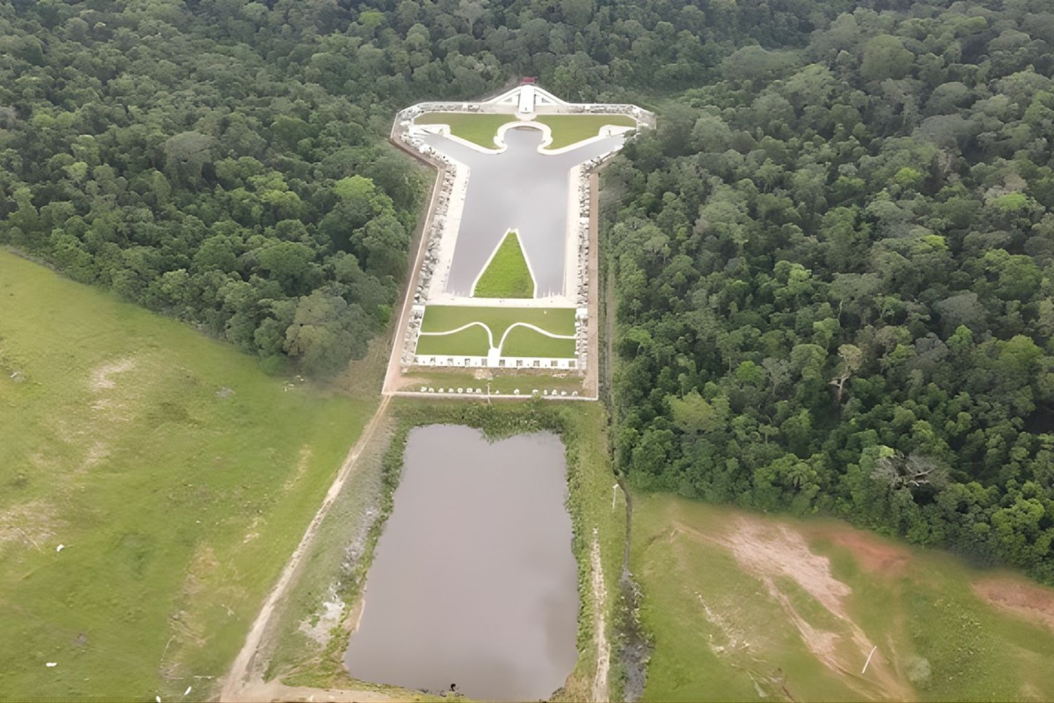
In the interior of São Paulo, a giant lagoon in the shape of a human body appears on Google Earth, flanked by 12 symmetrical chapels, and no one knows why.
-
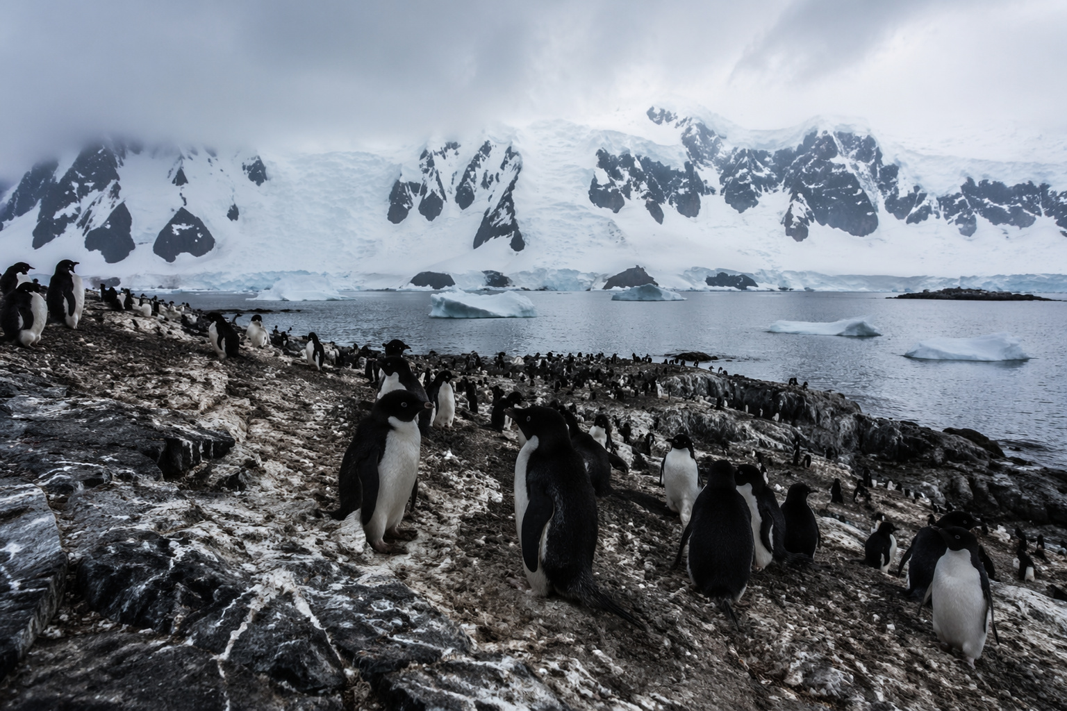
An invisible phenomenon in Antarctica on a continental scale reveals a direct impact on the polar climate by showing that penguin droppings release ammonia, form bright clouds, and raise an unexpected scientific curiosity about the balance of the icy atmosphere.
-
Mato Grosso regulates native wood biomass with certification, traceability, and a forest plan for 2025–2040 to boost the green economy and energy transition.

Sinan region brings together more than a thousand islands and creates one of the most fragmented coasts in Asia
The basis of this impressive visual pattern lies in the geography of the region itself. The Sinan archipelago, located in southwestern South Korea, is home to more than a thousand islands, many of them small and separated by narrow channels.
This type of geographical formation is the result of geological processes and the continuous action of tides, which over thousands of years have shaped the coastline irregularly. The result is one of the most fragmented coasts in Asia, where the line between land and water is not defined by simple contours but by a complex sequence of indentations, islands, and floodable areas.
When observed from space, this pattern creates a unique visual texture, with organic shapes fitting together like pieces of a natural mosaic. However, this would already be an impressive landscape by itself. What makes it even more unique is the intense presence of human structures that enhance this complexity.
Salinas and production areas expand the geometric pattern and make the landscape even more visible from space
In addition to natural formations, the region is known for its sea salt production, a traditional activity that uses the specific conditions of the coastline to evaporate seawater in shallow ponds.
These salinas are organized into compartments defined by dikes, creating flat surfaces that contrast with the irregular shapes of the surroundings. When viewed from space, these areas add a geometric component to the scene, forming blocks that stand out against the natural environment.

In certain areas, the salinas spread over large expanses, creating repetitive patterns that reinforce the feeling of a designed territory. This combination of natural forms and productive structures creates a hybrid landscape that would hardly be recognized as spontaneous.
Interaction between tides and mudflats creates dynamic patterns visible from satellite
Another fundamental element to understand this landscape is the presence of extensive mudflats, known as tidal flats. These areas are periodically covered and uncovered by the tides, creating an environment in constant transformation.
The tides expose and conceal parts of the territory throughout the day, altering the appearance of the region in short intervals of time. When captured by satellites, these variations create visual patterns that seem to move, reinforcing the sense of a dynamic territory.
These mudflats also play an important role in biodiversity and the local economy, serving as a base for activities such as fishing and shellfish gathering. However, from a visual perspective, they contribute to the complexity of the mosaic observed from space.
Human infrastructure connects islands and reorganizes the territory over time
Over the past few decades, the region has undergone a process of integration through the construction of bridges, dikes, and roads that connect some of the islands. These structures have partially modified the local dynamics, creating new forms of circulation and occupation.
Even so, the fragmented essence of the landscape has been maintained, and the infrastructure has adapted to the terrain rather than completely transforming it. This means that human connections have been incorporated into the existing mosaic, adding new layers of complexity to the scene.
When viewed from space, these interventions appear as lines crossing the territory, connecting isolated areas without eliminating their individuality.
Pattern seen from space combines nature and human activity on an uncommon scale
What makes this region particularly interesting is the balance between natural elements and artificial structures. Unlike fully urbanized areas or completely preserved ones, the southwestern coast of South Korea presents a combination of both.

Natural islands, mudflats, salinas, and infrastructure coexist in the same space, creating a pattern that cannot be classified as purely natural or artificial. This characteristic makes the landscape difficult to interpret without context, especially when observed from space.
The repetition of shapes, the alternation between land and water, and the presence of geometric patterns make the whole resemble a complex mosaic, where each element contributes to the final design.
Satellite observation reveals details invisible at ground level
At ground level, the region is perceived as a sequence of islands and coastal areas with local activities. However, it is only through satellite observation that the true scale and organization of the territory become evident.
The orbital view allows identifying patterns that connect different parts of the landscape, revealing a logic that is not perceptible to those immersed in the environment. This perspective broadens the understanding of how the territory has been shaped over time.
In the case of South Korea, the images show that the region is not just a collection of islands, but a complex system where each element is interconnected.
Region becomes a reference in coastal geography and land use studies
Due to its uniqueness, the southwestern coast of South Korea is frequently used in coastal geography and tidal dynamics studies. The interaction between natural processes and human intervention offers a relevant field of analysis for researchers.
These studies seek to understand how:
- the tides influence the formation of the territory
- human activities modify the coastal environment
- the landscape evolves over time
The region has thus become an important example of how different factors can simultaneously act in the formation of a geographical space.
What looks like an artificial design from space is the result of centuries of interaction between nature and society
When observing satellite images, it is easy to interpret the pattern as something planned. However, the reality is more complex. The landscape is the result of centuries of interaction between natural processes and human activities, which together have gradually shaped the territory.
Each island, each channel, and each productive area contributes to a whole that was not designed at once but built over time. This characteristic makes the place unique, as it combines elements that, in isolation, would not be as impactful.
Have you ever imagined that an entire coast can look like a puzzle when seen from space?
The southwestern region of South Korea shows how the combination of geography and human activity can create surprising patterns when observed from a broader perspective. What seems common at ground level transforms into something extraordinary when viewed from space.
In light of this, an interesting reflection arises: how many other regions of the planet hide such complex patterns that can only be understood when observed from outside the Earth? Share your thoughts in the comments.


Seja o primeiro a reagir!