 Portuguese
  English
  Spanish
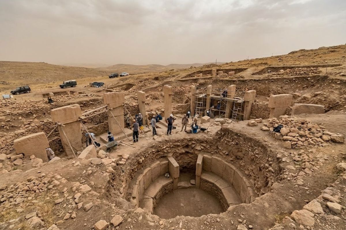


Karahan Tepe, in Southeast Anatolia, Revealed an Archaeological System with T-Pillars Up to 5.5 Meters, Subterranean Chambers Carved into Rock, Standardized Iconography, and Regional Coordination Without Agriculture or Writing, Followed by Progressive Technical Decline and Deliberate Burial Between 9,600 B.C. and 8,000 B.C.
Karahan Tepe has definitively entered the center of world archaeology by exposing a challenging paradox to accommodate within classical models. The oldest layers concentrate the most sophisticated works, while the more recent levels show architectural simplification, loss of artistic detail, and reduction in construction scale. This pattern, confirmed by stratigraphy and dating, breaks the linear narrative of technological progress.
The intensified excavations between 2019 and 2025 consolidated this scenario. What is observed is not a gradual evolution, but an inverse trajectory: monumental beginnings, early technical peak, decline, and ritual closure. The set suggests long-term planning, advanced technical mastery, and broad social coordination in a context preceding agriculture and writing.
Location, Chronology, and Regional Context

Karahan Tepe is located in Southeast Anatolia, an area now associated with the province of Şanlıurfa, within an archaeological corridor where multiple pre-pottery sites share structural and symbolic characteristics. The general chronology positions the site between approximately 9,600 B.C. and 8,000 B.C., with well-defined phases of construction, remodeling, simplification, and abandonment.
-
Health issues urgent alert for flu and calls for the vaccination of the elderly, children, and pregnant women this Saturday with Day D and drive-thru in Curitiba.

-
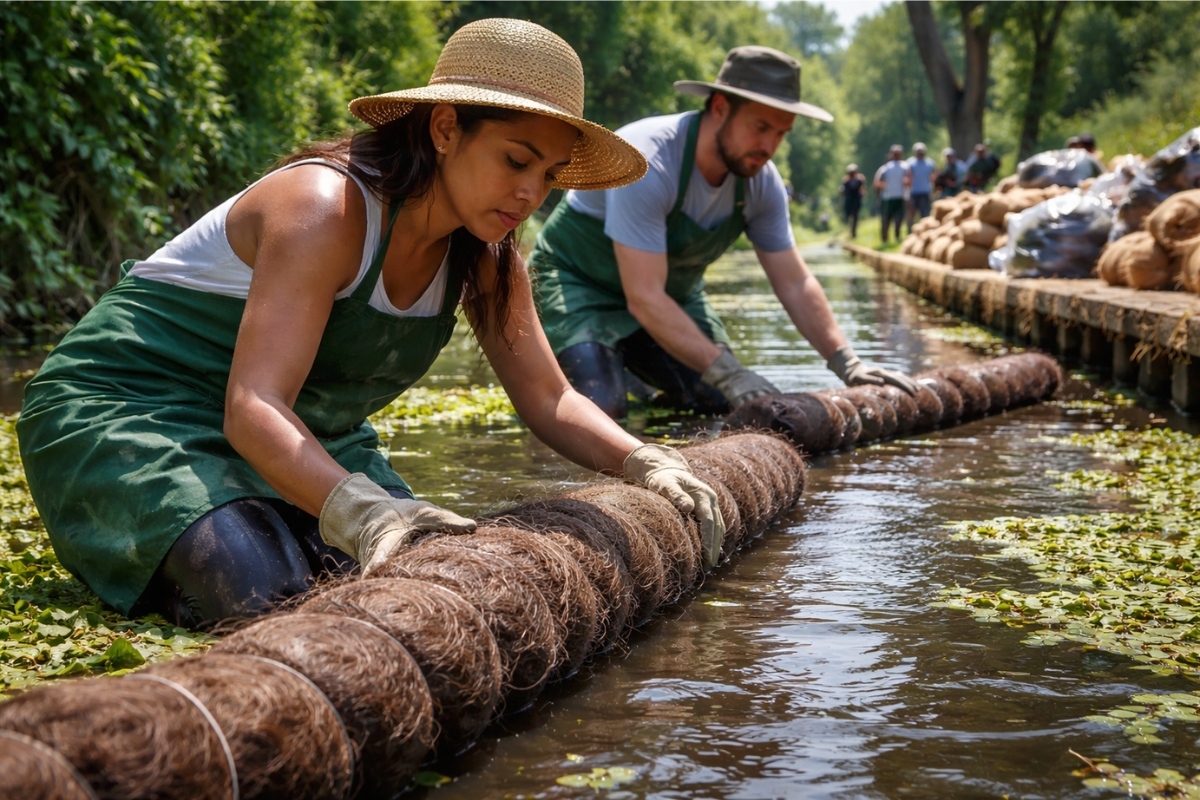
What seemed like waste has turned into a barrier, and now human hair collected from salons helps retain debris in the water of ancestral channels in Latin America.
-
China has deployed more than 1,400 fishing boats in formation, creating a barrier of 320 kilometers at sea, and the whole world wants to know if this is fishing, a military exercise, or a message of war.

-
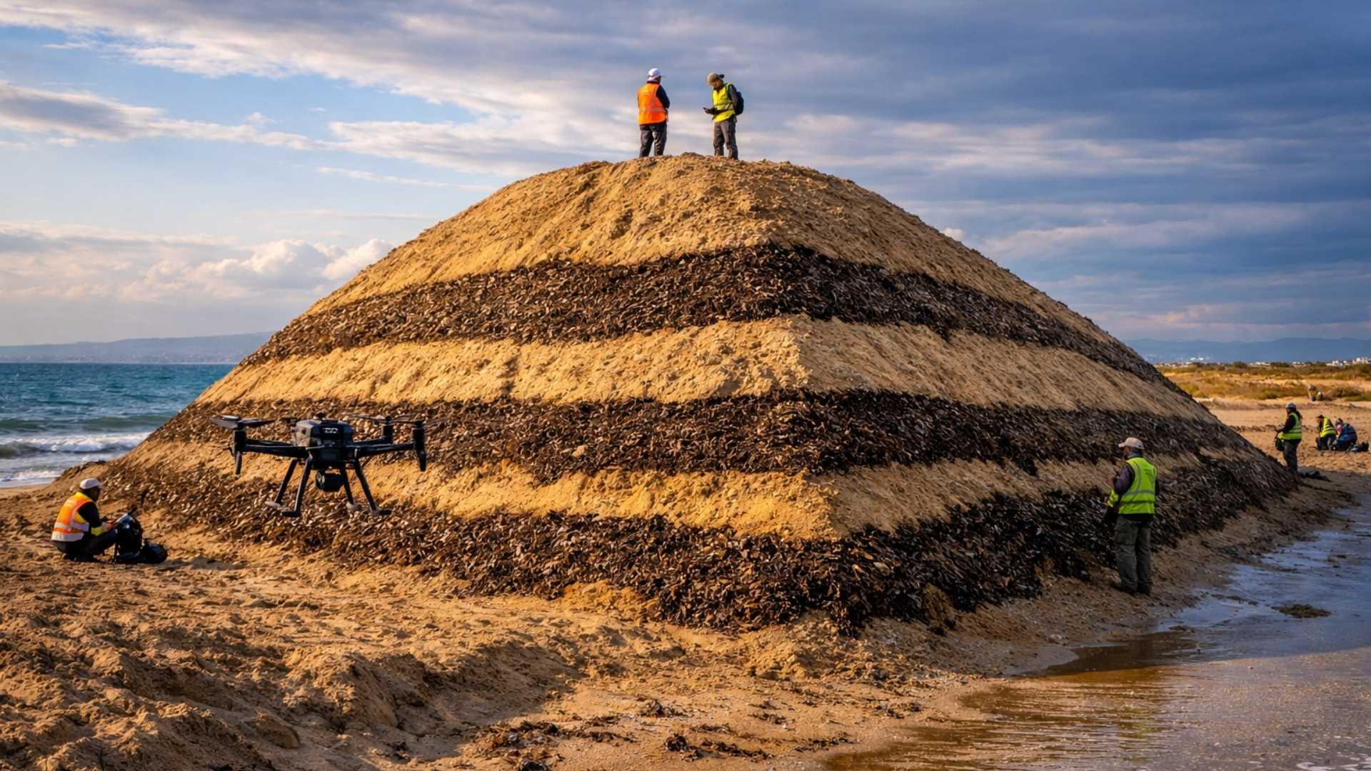
Spain surprises the world by erecting 62 artificial dunes, mixing sand with natural remains of posidonia, and causing the structure to lose only 1.4% of its volume in 1 year.

This temporal range precedes pyramids, Stonehenge, and any fully established agricultural society. It is a period associated with mobile hunter-gatherer groups, lacking pottery, domestication of plants or animals, and formal writing systems. Still, the material record indicates a social complexity incompatible with the traditional image of this way of life.
Monumental Architecture Above and Below Ground

The architectural core of Karahan Tepe consists of at least 11 megalithic structures, organized in circular or oval enclosures. The dominant element is the T-pillars, carved from monolithic blocks, some reaching 5.5 meters in height. The formal standardization is evident, with recurring proportions between vertical axis and upper crossbar, indicating a shared construction model.
The decisive differential of the site lies below the surface. Karahan Tepe houses an extensive network of subterranean chambers carved directly into the bedrock. These are not natural cavities, but deliberately hewn spaces, with integrated pillars, continuous benches, niches, and stone basins. Some of these basins are of sizes compatible with the containment of liquids, possibly associated with ritual practices.
The walls of these chambers include relief and high relief sculptures, featuring stylized human figures, felines in attack posture, intertwined snakes, and hybrid forms. The surface finishing is described as smooth and precise, with technical control requiring prior planning and careful execution.
Sculpture, Iconography, and Anatomical Knowledge

The sculptures of Karahan Tepe stand out for their visual intensity and formal mastery. The animals display coherent proportions, suggested musculature, and gestures frozen in motion. The human figures, although stylized, show faces with marked expressions and strong symbolic presence.
This iconographic repertoire is repeated in other sites in the region, with recurring themes such as snakes, foxes, wild boars, birds, and abstract symbols. The repetition of motifs in areas separated by more than 100 km points to a shared symbolic system, rather than isolated productions.
Stratigraphy and the Inversion of the Evolutionary Model

The stratigraphic reading is the central point of the interpretive turnaround. The deepest levels of Karahan Tepe, therefore the oldest, concentrate the largest pillars, the most detailed carvings, and the most ambitious enclosures in terms of spatial planning.
As the upper strata emerge, a gradual decline is observed. The pillars become smaller, the carvings more schematic, and the compositions less complex. In later phases, rectangular structures begin to replace circular enclosures, and the monumental character gives way to constructions of a functional appearance.
This pattern violates a basic premise of traditional archaeology, according to which human societies advance from simple to complex forms. At Karahan Tepe, the material record points to the opposite.
A Coordinated Regional Network in Anatolia
Karahan Tepe is not an isolated case. More than a dozen pre-pottery sites in Southeast Anatolia share T-pillars, circular enclosures, animal iconography, and similar chronologies. This ensemble has come to be recognized as an integrated cultural landscape, often referred to as the stone hills.
The connection between these sites is supported by multiple pieces of evidence. The iconography repeats specific symbols at various points. The architecture follows consistent proportional patterns. Petrographic analyses indicate that some sites used stone from common quarries, with transportation of blocks over distances greater than 50 km, without wheels or pack animals.
Astronomy, Calendar, and Social Mobilization
Another recurring element is the architectural orientation. Various enclosures exhibit alignments with astronomical events, such as solstices, equinoxes, and the rise of specific constellations on the horizon. This pattern suggests applied astronomical knowledge and a shared ritual calendar.
The social implication is profound. The construction and maintenance of these sites would require seasonal gatherings of large groups, synchronized in time and space. These are not isolated villages, but an integrated regional system, with circulation of people, symbols, and resources.
Scale of Labor and Logistics Without Agriculture
Estimates based on material volume and construction complexity indicate that just one large enclosure would require hundreds of workers for months. The tasks would include extracting blocks weighing up to 20 tons, manual transport, carving with stone tools, precise positioning, and execution of reliefs.
When this effort is multiplied across several actively operating centers simultaneously, the result points to thousands of people mobilized, with feeding, task coordination, and leadership. All of this occurs in a context without formal agriculture, without pottery, and without known large permanent settlements.
Intensive Hunting and Shared Food Base
Zooarchaeological analyses indicate intensive exploitation of gazelles, possibly during seasonal migrations, which would allow for large-scale captures. This pattern could sustain large human concentrations for limited periods.
Isotopic data from human remains suggest similar diets across broad areas, compatible with shared hunting territories or food exchange networks that could extend up to 200 km. This homogeneity reinforces the idea of regional integration, not of disconnected autonomous groups.
Chronology from Peak to Deliberate Abandonment
Between 9,600 B.C. and 9,400 B.C., the record points to the peak of construction. Pillars reach maximum dimensions, carvings show a high degree of naturalism, and the enclosures exhibit sophisticated geometric planning.
From 9,400 B.C. to 9,000 B.C., the decline becomes noticeable. New constructions are smaller, reuse old elements, and have less detail. Between 9,000 B.C. and 8,500 B.C., there is a clear simplification, with reduced monumental symbolism.
Starting from 8,500 B.C., abandonment begins. The most singular aspect is the deliberate closure. Enclosures are filled with large volumes of material, subterranean chambers are sealed, and the sites are hidden beneath the earth. There are no signs of widespread violent destruction, but rather intentional closure.
Hypotheses for Decline and Closure
Three main hypotheses are debated. The first involves climatic changes associated with the end of a cold period, with vegetation alteration and reduction of large herds. Paleoenvironmental evidence supports part of this argument, but the onset of decline precedes the peak of the changes.
The second hypothesis associates the process with the transition to agriculture, which begins to emerge in the region around 8,500 B.C. Settling in agricultural plots would have reduced mobility and the ability to gather large contingents for monumental works. The paradox is that agriculture, typically seen as a driver of complexity, coincides here with its retraction.
The third hypothesis considers a social or ritual collapse, possibly associated with internal tensions, loss of specialists, or profound symbolic transformations. The absence of clear evidence of warfare suggests a cultural rupture, not a destructive event.
What Remains Hidden
Despite recent excavations, it is estimated that only about 10 percent of Karahan Tepe has been investigated. Geophysical surveys indicate dozens of additional anomalies in the region, suggesting the existence of many other sites still buried.
The campaigns until 2025 have been revealing new data each season. Future analyses of ancient DNA may clarify population movements. Residue studies in the stone basins may indicate substances used in rituals. The greatest unknown remains where these people lived, as the monumental sites have been identified, but not the everyday settlements.
Karahan Tepe imposes a profound reassessment of how human societies can achieve and lose complexity. The site demonstrates that groups without agriculture and writing were able to plan, coordinate, and execute monumental works on a regional scale, maintaining an integrated system for centuries.
The deliberate closure of these constructions, followed by millennia of concealment, remains one of the most intriguing episodes of prehistory. As new excavations advance in Anatolia, the understanding of this system is likely to deepen, but also to challenge even more established certainties.
In your assessment, what best explains the end of this monumental system: climate changes, the transition to agriculture, or an internal social rupture?


Pois é, negar o óbvio não é ciência,teve sim um epis**** que aniquilou essa dinâmica humana, todos sabem,tem medo de revelar,essa catástrofe tem nome DILÚVIO
video doesn’t seem to be working
Excelente matéria parabéns. Acredito que as mudanças climáticas e a dificuldade de alimentos ocasionou no abandono do local.