 Portuguese
  English
  Spanish
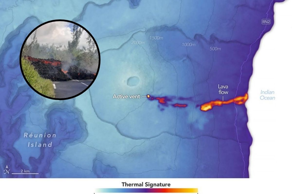
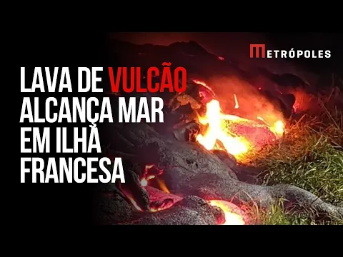
The eruption of 2026 at Piton de la Fournaise is already the longest and most intense of the year, with basaltic lava above 1,100°C, acid plumes on the coast, and a new delta that extended the coastline
The Piton de la Fournaise volcano on Reunion Island has once again shown why it is one of the most active in the world. The eruption that began on February 13, 2026, not only maintained its pace for weeks but also generated a river of lava that flowed down the slope, crossed a highway, and reached the Indian Ocean, creating new land in real time.
What stands out in this phase of the volcano is the combination of duration and volume. Researchers point out that the eruption seems longer and with more lava than usual, and this may be linked to the beginning of a new cycle of activity, as the previous cycle is believed to have ended in July 2023.
Where the volcano is and why Reunion Island is so active
Reunion Island is located about 700 kilometers east of Madagascar in the Indian Ocean. It was formed by a hot spot in the oceanic mantle and emerged about 2 million years ago, but remains active today due to the frequent eruptions of Piton de la Fournaise.
-
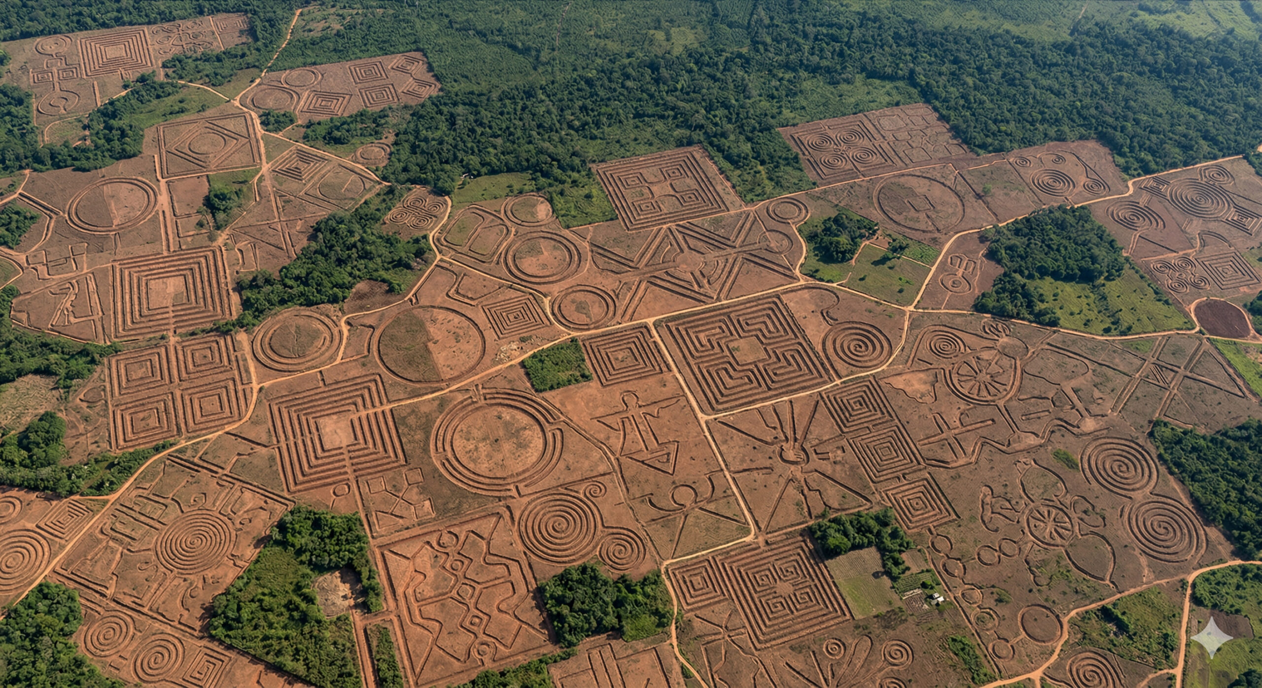
More than 400 geoglyphs up to 350 meters long were excavated over 2,000 years ago in Acre and remained hidden under the forest for centuries. These giant structures, now visible in satellite images, still challenge science regarding their origin and function.
-
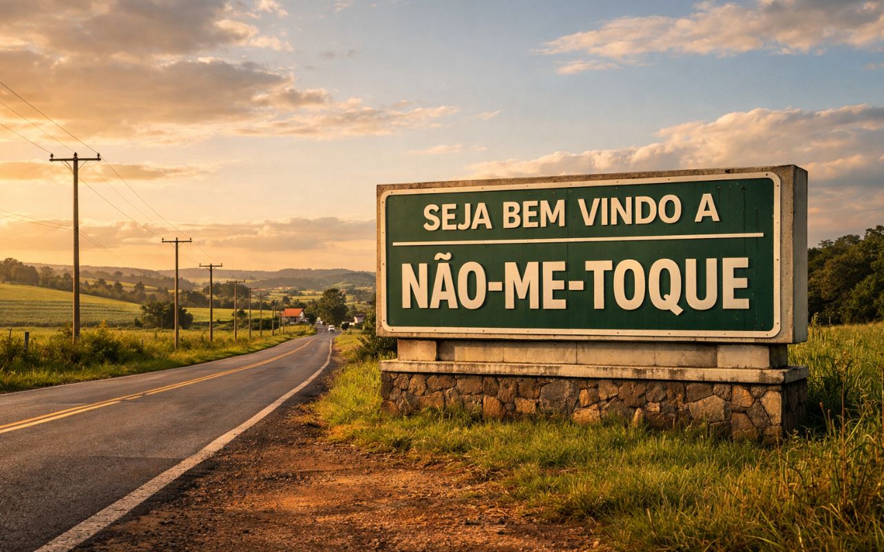
Few people know, but in Brazil there are cities with curious names like Feliz Natal, Não-me-Toque, and Varre-Sai, which may seem like random names, but originated from real events, local habits, and natural characteristics.
-
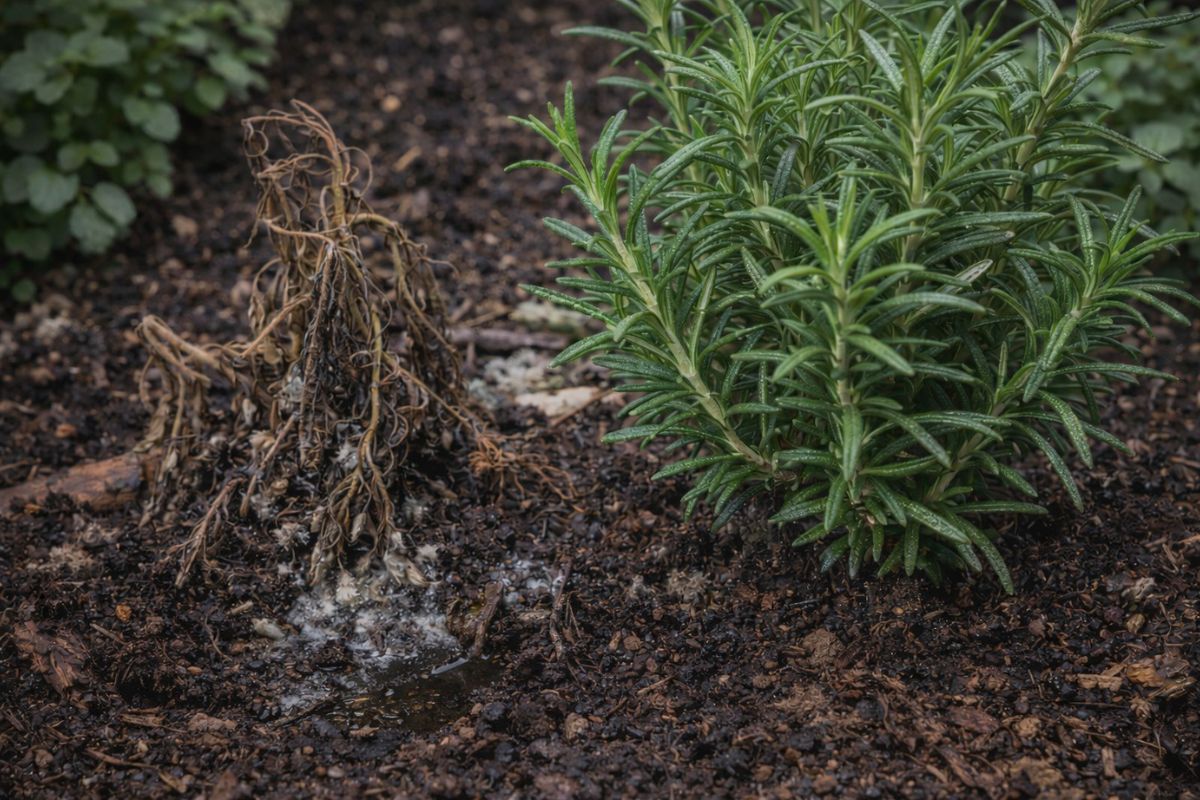
No one told you this about rosemary: there is a plant that silently rots its roots, and the place where you plant it makes all the difference between a vigorous herb and a dead plant in just a few weeks.
-
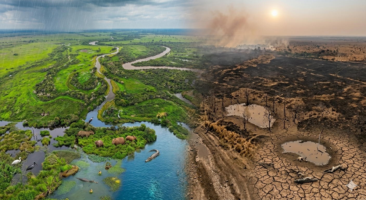
The largest swamp on the planet has lost 57% of its water in less than 12 months, rivers have reached their lowest levels since records began, and NASA satellites have documented in real time the most extreme transformation ever recorded in the Pantanal: the biome, which should be flooded, has turned into a cracked savanna for the first time in 50 years.
Since the 17th century, the volcano has had over 150 documented eruptions. This regularity explains why the place combines impressive landscapes with a routine of constant monitoring.
How the eruption of 2026 began and why it became a spectacle

The most recent eruption began in the Enclos Fouqué caldera, with the opening of four fissures that fed continuous lava fountains, reaching heights of 10 to 50 meters. Throughout February and March, basaltic lava flowed down the volcano, advancing through forested and grassy areas and heading towards the eastern side of the island.
Thermal images recorded on March 28, 2026, show the lava flowing east toward the ocean. The contrast is striking: bright heat channels against cooler vegetation and rocks, revealing the front of the flow and hot spots where the lava reappears on the surface.
The day the lava crossed the road and changed local logistics
The advance of the volcano was not limited to remote areas. On March 13, the lava made its way through Route Nationale 2, the RN2, making sections impassable and highlighting how a natural event can reshape routes in just a few hours.
This type of episode reinforces the dual nature of Piton de la Fournaise: while it creates landscapes, it imposes interruptions and real risks to infrastructure.
When the lava entered the sea and what is laze

On March 16, the lava began to overflow into the Indian Ocean. This encounter between incandescent rock and seawater generated acid plumes of steam and volcanic gases known as laze, a typical effect when lava enters the ocean.
Field scientists measured lava temperatures between 1,100 and 1,130°C as it approached the coast. Thermal surveys also indicated that water temperatures exceeded 36°C up to 600 meters from the entry point.
The new strip of land that appeared on the coast
The advance of the volcano not only reached the sea but also began to build soil. On March 24, the material entering the ocean had already created a new lava delta that extended the coastline by 190 meters.
It is literally the island growing, with a newly formed edge where there was once only water.
Why this eruption may mark a new cycle of the volcano
Researchers point out that the current eruption seems to be longer and has produced a larger volume of lava than usual, characteristics often associated with the beginning or end of an eruptive cycle. The most recent cycle is believed to have started in 2014, peaked in 2015, and ended in July 2023.
In this context, the activity of 2026 may be a sign of a new period of frequent eruptions at the volcano, making monitoring even more important in the coming months.
What satellites show and why the images are so valuable
In addition to thermal images, high-resolution records show details such as vegetation burning in the path of the lava, possible lava tunnels forming, roads cut off, and the creation of new land along the coast. These series of images help track the evolution of the phenomenon and measure the extent of the impact.
Seeing the coastline change in a matter of days is a reminder that, in places like Reunion Island, geography is not something fixed.
Do you think the formation of new land by a volcano is more fascinating or more frightening to witness up close?


Seja o primeiro a reagir!