 Portuguese
  English
  Spanish
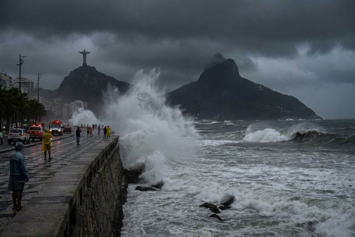
The New Surf Warning from the Navy Applies to the Beaches of Rio de Janeiro Starting at 3 PM This Saturday (3), with Waves of Up to 3 Meters, and Lasts Until 6 AM on Monday (5). COR-Rio Reinforces Caution, Firefighters Increase Team, and the Warning Comes After 1,167 Rescues on New Year’s Eve.
The Brazilian Navy issued a new surf warning for the beaches of Rio de Janeiro, valid starting at 3 PM this Saturday (3). The notice predicts waves of up to 3 meters and brings a direct message to the public: do not enter the sea during the risk period.
The new warning extends until 6 AM on Monday (5) and aims to reinforce the safety of bathers and fishermen along the coastline, with support from COR-Rio. The guidance comes amid recent reports of incidents by the Fire Department and after a previous surf warning on New Year’s Eve, which ended with 1,167 rescues.
What the New Warning Really Aims to Avoid
The central point of the new warning is to reduce exposure to a set of risks that usually increase during surf events: stronger waves, impact on the sandy beach, currents, and rapid changes in sea conditions.
-
Dozens of Chinese research ships are discreetly mapping the ocean floor in three oceans – and naval analysts see a military pattern.

-
The winter of 2026 in Brazil will not be what you expect: meteorologists warn that the season will be warm and rainy at the same time due to the advance of El Niño, which is already warming the Pacific and changing the climate of the entire country.

-
For the first time, humanoid robots will compete in a full half-marathon without any human assistance in Beijing, with over 100 teams from China registering machines that need to complete the course with autonomous navigation on two legs.

-
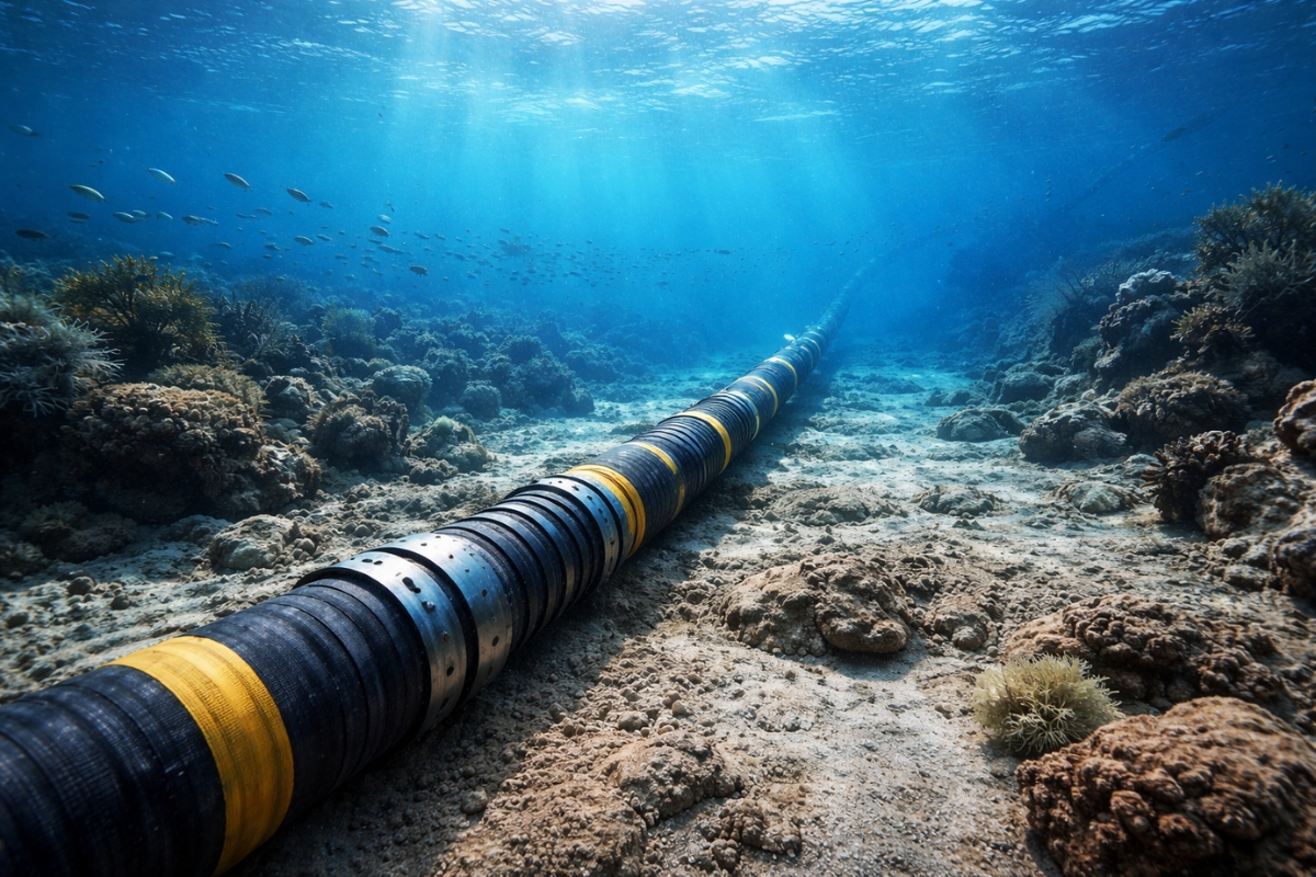
Submarine cables installed to transmit the internet now also help scientists detect earthquakes.

Even those who “just want to dip their toes” need to consider the official recommendation because the surf does not only affect those swimming far. A stronger wave can knock you down, drag you, and disorient you in just a few seconds, especially in current and return areas.
Period of the New Warning: Start and End Times of the Risk
To avoid confusion, the interval of the new warning is clearly defined:
- Start: 3 PM on Saturday (3)
- End: 6 AM on Monday (5)
- Expected Condition: waves of up to 3 meters
This means that the risk is not “only on Saturday” or “only when the weather turns bad.” The entire window of the warning should be treated as a period of maximum caution, including early morning and dawn, when many people tend to go to the beach.
Where the New Warning Applies and Why the Coast Needs Extra Attention
The new warning is directed at the beaches of Rio de Janeiro, focusing on safety along the coastline.
The notice reinforces that the measure seeks to protect bathers and fishermen, precisely because the surf usually changes the dynamics of the sea in various stretches of the coast.
In addition to the recommendation not to enter the sea, the warning points out behaviors that may seem harmless but become dangerous when the waves gain strength and range.
Objective Recommendations: What to Avoid During the New Warning
During the new warning, the guidelines are clear and repeatedly stated by the authorities:
- Avoid swimming in the sea
- Avoid water sports
- Avoid staying at viewpoints and elevated areas near the impact of the waves
- Avoid fishing navigation during the surf period
The goal is to reduce situations where a wave or a current surprises those who are distracted. This is not a warning to “be careful,” it is a warning not to expose yourself.
Viewpoints, Rocks, and Coastline Edges: The Risk Many Underestimate
The new warning highlights the guidance to avoid staying at viewpoints for a simple reason: waves can reach areas where people feel safe.
On days of rough seas, it is common for curiosity to increase, and the shore to become an “observation point.”
However, the surf can launch water with force, cause slips, and knock people down. A photo near the impact of the waves can cost you dearly.
Bicycle Lanes and Movement Along the Shore: Why the New Warning Mentions Danger Outside of the Water
An important detail of the new warning is that it does not only talk about swimming in the sea. It mentions that in bicycle lanes, the flow of bicycles can become dangerous.
This happens because the agitation of the sea can carry water and debris into passage areas and reduce floor grip.
The risk is not just falling, but falling in a busy environment with reduced visibility. For those looking to move along the shore, the practical advice is: reduce speed, avoid exposed stretches, and prioritize alternative routes when possible.
Recent Incidents and the Priority of Safety
The Fire Department has recorded recent incidents, including the disappearance of a teenager at Copacabana Beach, which reinforces the preventive tone of the new warning.
The message from the authorities is that safety comes before leisure, especially during surf periods when the strength of the sea tends to increase and conditions change rapidly.
Summer Operation: Why the Personnel is Increased
The base text states that the Fire Department’s personnel is expanded this season through the Summer Operation, keeping up with the increase in visitor numbers.
In practice, this means more attention, more readiness, and greater response capacity, but it does not change the main rule of the new warning: not to rely on rescue as a plan.
The goal is to prevent an occurrence from happening.
The Number of 1,167 Rescues on New Year’s Eve and What It Indicates
The previous surf period, coinciding with New Year’s Eve, resulted in 1,167 rescues. This number is used as a reference for severity because it shows how the combination of rough seas and a large flow of people on the beach can lead to a sequence of incidents.
The message is direct: this is not a theoretical risk. When the surf comes in, the chances of incidents increase, and the result can be a rise in emergency responses.
Weather Forecast Until Monday: Unstable Weather May Aggravate Agitation
In addition to the waves, the weather forecast mentioned points to unstable weather in Rio de Janeiro, with cloudy skies and isolated rain showers expected from Saturday to Monday.
The text also mentions high humidity and cold fronts as factors that worsen the agitation of the sea and increase the risk of dangerous currents. For Monday (5), the expectation is a drop in temperature, with a maximum of 26°C.
In summary: the climatic scenario does not help to “calm” the sea, so the new warning should be taken literally.
How to Act Practically While the New Warning is in Effect
For those living in or visiting Rio and planning to go to the beach, the safest path during the new warning is to adjust plans:
- If the goal is to enter the sea, postpone
- If the idea is water sports, suspend
- If the plan is to stroll along the shore, avoid areas exposed to waves
- If cycling, increase attention and choose less vulnerable stretches
- If with children, elderly, or groups, reinforce guidance and supervision
Respect signals and guidance from the Fire Department and avoid risk areas are simple actions that greatly reduce the chance of incidents.
Do you think that the public really respects a new surf warning, or do most only take it seriously after seeing a rescue happening on the sand?


-

Uma pessoa reagiu a isso.