 Portuguese
  English
  Spanish
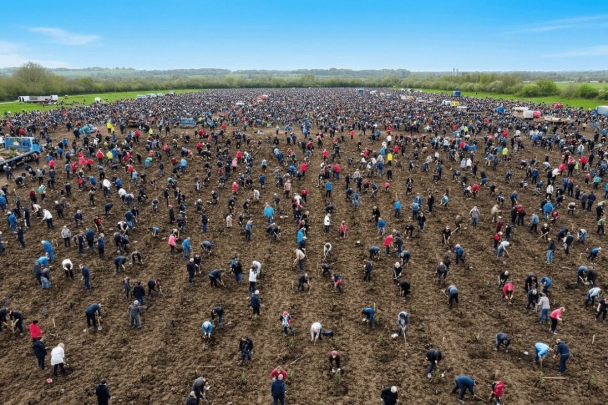
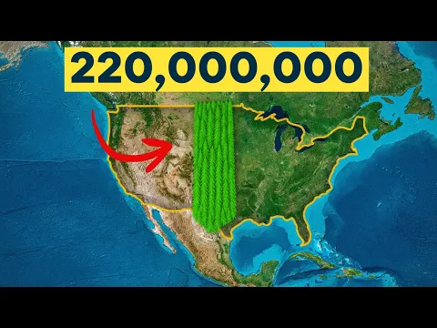
In The Plains, Millions of Trees Are Planted by the U.S. After Dust Storms in the 1930s Devoured Farms and Culminated in Black Sunday on April 14, 1935. In 1934, Prairie States Forestry Project Created Shelterbelts from Canada to Texas, Totaling 220 Million in the 1940s.
In the Great Plains, millions of trees are planted by the U.S. in response to a physical collapse of the land: vegetation cover was removed on an industrial scale, drought turned the topsoil into dust, and wind began to operate as a conveyor belt of dust for hundreds of miles.
The line of trees, visible even in satellite images, was designed to cut across the agricultural heart of the continent as green infrastructure. The idea was simple and extreme: slow down the wind, hold the soil, and stabilize crops in an area where the landscape only stands as long as the vegetation layer remains intact.
Where the Disaster Began: The Great Plains and the Fragility of Exposed Soil

The land chosen for the project is the Great Plains, which stretches from Alberta and Saskatchewan in Canada, across the Dakotas, Nebraska, Kansas, and Oklahoma, reaching the Texas panhandle in the U.S.
-
Italian researchers have detected what appears to be a second Sphinx buried under the sands of Egypt, and satellite scans reveal a gigantic underground megastructure hidden beneath the Giza Plateau for over 3,000 years.

-
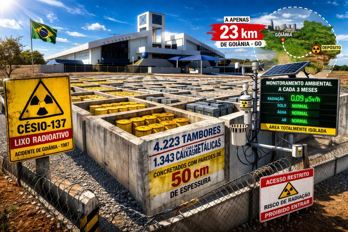
There are 4,223 drums and 1,343 metal boxes concreted with 50-centimeter walls that store the radioactive waste from Cesium-137 in the worst radiological accident in Brazil, just 23 kilometers from Goiânia, with environmental monitoring every three months.
-
Giant Roman treasure found at the bottom of Lake Neuchâtel in Switzerland reveals an advanced trade system, circulation of goods, and armed escort in the Roman Empire about two thousand years ago.

-
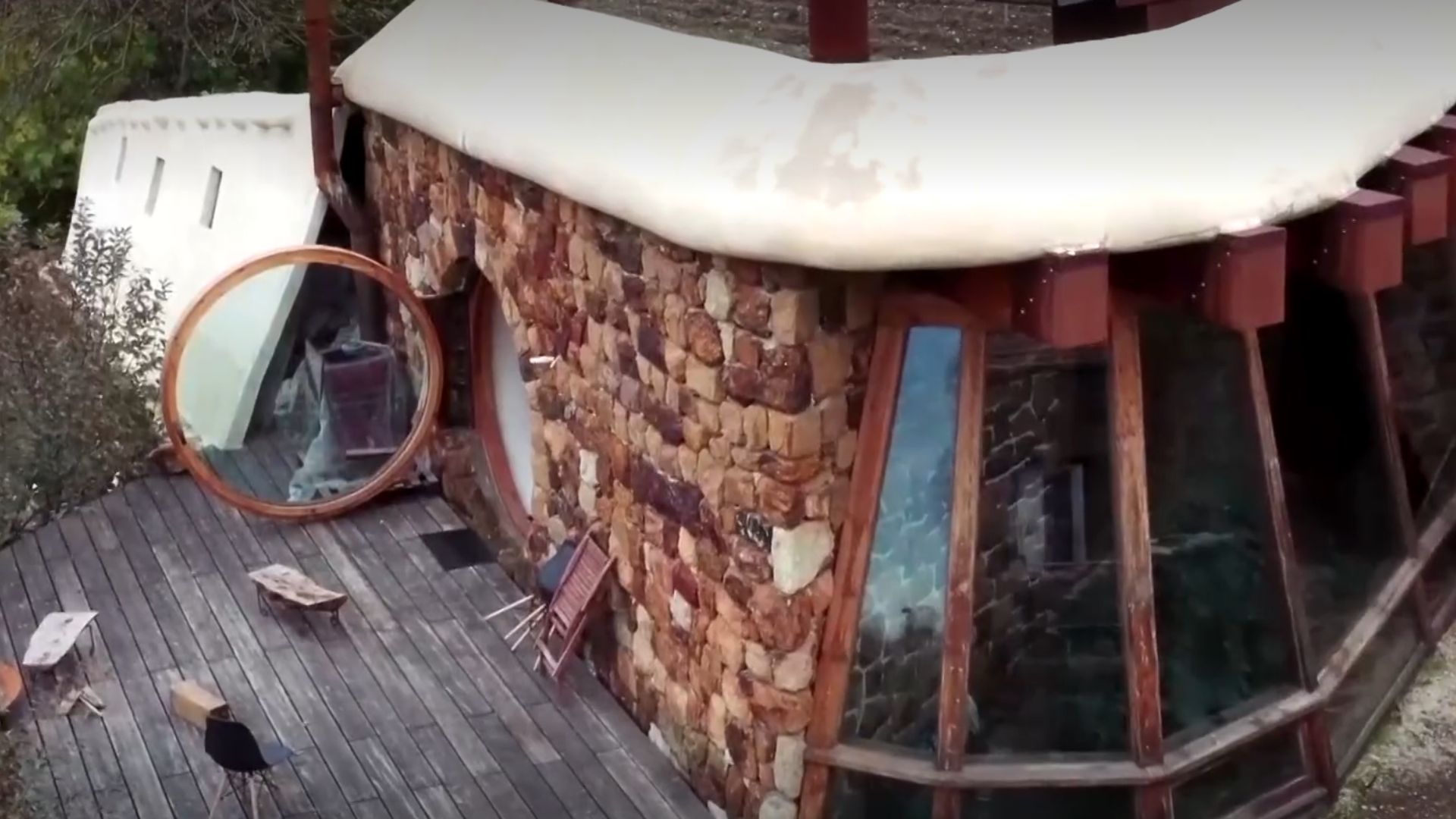
He buried 1,200 old tires in the walls to build his own self-sufficient house in the mountains with glass bottles, rainwater, and an integrated greenhouse.

The area is enormous: about 1,900 km from north to south, and up to 800 km wide, totaling nearly 1.3 million square kilometers of predominantly open land.
It is a semi-arid region, with limited and unpredictable rainfall. Much of the moisture coming from the Pacific remains on the western side of the Rocky Mountains; when air masses cross the peaks and reach the plains, they have already lost almost all the moisture.
Add to this the wind: prevailing westerly currents descend from the Rockies and sweep the land for hundreds of miles with almost nothing to slow them down.
The extremes are harsh: winter temperatures below -30°C and summer temperatures reaching 40°C, with air constantly in motion.
For thousands of years, however, the system held together because the prairie had a “foundation”: native grasses with deep roots that held the soil, bison grazing without destroying what mattered underground, and fires that burned the surface but allowed regrowth from buried roots.
The paradox of the Plains is this: they seem perfect for farms and towns, but they only remain stable as long as the vegetation cover is not stripped away.
The Turning Point After World War I: Wheat, Plowing, and Millions of Vulnerable Acres

After World War I, wheat became a “miracle” crop.
High prices and government incentives pushed farmers to plow more and more of the native prairie and replace it with fields of wheat.
In the 1930s, millions of acres of what was once deep-rooted prairie turned into bare, exposed, newly plowed land.
At first, it worked until the rain stopped.
The drought of the early 1930s turned the topsoil into loose dust. It was then that wind took control of the map.
Wind corridors that once passed over grasses holding the soil became “highways” for dust, carrying particles eastward toward the Mississippi and beyond.
It is in this context that millions of trees are planted by the U.S.: not as rural ornamentation, but as an attempt to interrupt a physical erosion mechanism on a continental scale.
Dust Bowl and Black Sunday: When Agriculture Began to Act Like a Desert
The worst storms hit the Oklahoma panhandle, Texas panhandle, western Kansas, eastern Colorado, and northeastern New Mexico, an area that became known as the Dust Bowl.
On April 14, 1935, Black Sunday brought the collapse to a symbol: a single storm carried 300,000 tons of topsoil eastward.
The dust reached Chicago and Washington D.C. Ships in the Atlantic reported dust falling on their decks 483 km from the coast.
It wasn’t “just a bad year.”
It was a system failure: part of North America stopped behaving like agricultural land and started behaving like a desert.
1934: The Shelterbelt as Green Infrastructure to Cross the Wind
In 1934, the Prairie States Forestry Project was launched with an engineering logic applied to ecology: to plant a strip of trees from north to south, cutting across the prevailing westerly winds sweeping across the Plains.
The aim was not to create a continuous forest but thousands of shelterbelts distributed along the edges of farms and fields.
Each shelterbelt aimed to reach 10 to 20 meters in height, with taller trees in the center and smaller shrubs on the edges to block low-level winds.
The choice of species varied with latitude: in the Dakotas and Nebraska, species capable of surviving brutal winters; further south, in Kansas and Oklahoma, trees that could withstand summer heat and drought; in the Texas panhandle, species adapted to even drier and harsher conditions.
The numerical result is evident in the scale: by the early 1940s, about 220 million trees had been planted within the corridor.
This was continental-scale landscape planning, designed to alter how an entire region physically “behaves.”
What a Shelterbelt Changes in the Soil: Wind, Humidity, Snow, and Productivity
The first effect is on the wind.
A shelterbelt of 15 meters in height doesn’t just block at the canopy level: it reduces wind speed by up to 15 to 20 times its height in the wind direction, creating a calmer air strip that can extend several hundred meters behind the barrier.
In practice, the practical consequence is direct: speeds can drop by half in this zone, reducing erosion, “sand blasting” on crops, and accumulation of snow in the wrong places.
Next comes the microclimate: behind the shelterbelts, humidity tends to rise, summer temperatures drop slightly, and the air becomes more stable.
In winter, the trees capture snow and hold it in place to melt slowly and infiltrate the soil, instead of being blown into ditches and fences.
In agricultural production, the described effect is stability, with protected areas often recording 10% to 20% increase in productivity.
The farms themselves reorganize: rural headquarters move closer to tree lines for shelter, and roads tend to follow these corridors since they are routes less battered by the wind.
In this sense, millions of trees are planted by the U.S. as a physical “brake”: to reduce wind energy to prevent the soil from turning back into transportable dust.
Why Dust Decreased and What Remains: Recovery, Tree Removal, and a New Cycle of Risk
The Dust Bowl ended with improved agricultural practices and a return of wetter weather.
But the shelterbelts helped to “lock in” this recovery, making part of the vulnerable soil again suitable to stay in place as agricultural land.
Today, the shelterbelts are still visible, but unevenly.
In some areas, especially in the northern Plains, dense networks of tree lines are still evident in satellite imagery.
In others, they have been removed: larger fields, larger machines, and center pivot irrigation have turned narrow strips of trees into obstacles, not assets.
Mapping projects clearly show the mosaic: zones where the shelterbelts survive and zones where they have nearly disappeared, like fossil infrastructure slowly crumbling away.
Except that climatic conditions have started to press the system again: more frequent droughts, hotter summers, and stronger winds.
The decline of the Ogallala aquifer makes irrigation expensive or unfeasible in some areas.
In this scenario, farmers are re-evaluating the cost-benefit: trees consume water, but they also reduce water loss from crops due to wind and evaporation.
It is a trade-off, and in some places, it is starting to make sense again.
The Global Domino Effect: China, Sahel, and Australia Observe the Same Logic
The American experiment was not isolated.
In 1978, China launched its equivalent, the Three-North Shelterbelt, also called the Great Green Wall, stretching more than 4,500 km along the southern edge of the Gobi Desert to contain desertification and sandstorms that buried villages and suffocated cities.
In Africa, the Great Green Wall extends along the Sahel, from Senegal to Djibouti, a belt of 8,000 km of restored vegetation aimed at halting the advance of the Sahara and stabilizing rural livelihoods.
Australia is also operating networks of shelterbelts to combat erosion and soil salinity in the interior.
The pattern is the same: green lines as continental infrastructure, designed to reduce wind, hold soil, and buy time for agriculture in marginal regions.
The “shelterbelt” in the Great Plains was a direct response to a system failure triggered by drought, plowing, and wind, with Black Sunday on April 14, 1935, marking the breaking point.
By planting 220 million trees in shelterbelts, the U.S. attempted to redesign the physical behavior of the landscape, transforming trees into barriers, microclimate, and soil protection.
If you could decide today, millions of trees are planted by the U.S. should once again become a priority in the Plains as green infrastructure, even with the cost of water and land, or has the model become stuck in the past?


-

-

-

-

-

26 pessoas reagiram a isso.