 Portuguese
  English
  Spanish
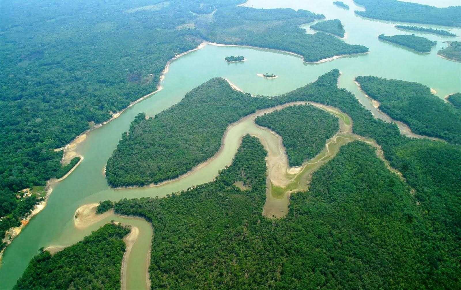


With Almost 1,500 Km in Length, This Giant Originates in the Interior of Piauí, Crosses the Heart of the Northeast, and Forms One of the Rare Open-Sea Deltas in the Americas
The Parnaíba River, fondly known as the “Old Monk”, is one of the main waterways in the Northeast of Brazil.
Flowing between the states of Maranhão and Piauí, it serves as a natural border between these two territories.
With approximately 1,400 to 1,500 kilometers in length, it is considered the largest genuinely Northeastern river, traversing its entire path within the region and being navigable for a large part of its course.
-
Friends have been building a small “town” for 30 years to grow old together, with compact houses, a common area, nature surrounding it, and a collective life project designed for friendship, coexistence, and simplicity.

-
This small town in Germany created its own currency 24 years ago, today it circulates millions per year, is accepted in over 300 stores, and the German government allowed all of this to happen under one condition.

-
Curitiba is shrinking and is expected to lose 97,000 residents by 2050, while inland cities in Paraná such as Sarandi, Araucária, and Toledo are experiencing accelerated growth that is changing the entire state’s map.

-
Tourists were poisoned on Everest in a million-dollar fraud scheme involving helicopters that diverted over $19 million and shocked international authorities.


Essential for water supply and the economic life of the Mid-North Northeastern region, the Parnaíba stands out as a true artery of the area, supporting riverside populations, cities, and entire ecosystems.

Length, Source, and Mouth
The Parnaíba originates in the Chapada das Mangabeiras, an elevated formation located on the border between Piauí, Maranhão, Bahia, and Tocantins.
Its source is located at about 700 meters above sea level in the Serra da Tabatinga, a region now protected by the National Park of the Headwaters of the Parnaíba River.
There, the confluence of small rivers such as Água Quente, Curriola, and Lontra gives rise to the Parnaíba, which begins its long journey towards the Atlantic.
From its headwaters in southern Piauí, the river flows approximately 1,450 km predominantly northward, serving as a natural border between Piauí and Maranhão for almost its entire route.
After winding through the northeastern interior, the Parnaíba empties into the Atlantic Ocean, in a spectacular conclusion: its delta mouth. Near the coastal city of Parnaíba (PI), the river spreads into multiple arms and channels, forming the Parnaíba Delta, the only open-sea delta on the entire American continent.
This delta has five main outlets – among them the arms Igaraçu, Canários, and Tutóia – that embrace a riverine archipelago with dozens of islands before reaching the sea.
Located between the territories of Piauí and Maranhão, the Parnaíba Delta impresses with its beauty and expanse, often being compared to other large deltas worldwide, such as those of the Nile and Mekong rivers.
Geographical and Hydrological Characteristics

In its upper course, in the plateau where it originates, the climate is tropical with average annual rainfall around 1,500 mm.
This regime ensures that the Parnaíba is a perennial river, with water year-round in its bed. As it flows northward, its waters wash various biomes – from the Cerrado in the higher sections to the Caatinga in the mid-course – and finally feed coastal mangrove ecosystems as it forms the delta near the Atlantic.
This diversity highlights the river’s ecological role, linking semi-arid regions of the interior to humid coastal areas, serving as a natural corridor between different environments.
Hydrologically, the Parnaíba is a pluvial regime river, meaning its floods and droughts primarily depend on seasonal rains.
In the initial stretch – known as Upper Parnaíba – the river has a steep slope, descending from the plateau in rapids and waterfalls over approximately 700 km until the Boa Esperança Dam.
As it progresses, the terrain becomes gentler: in the Mid Parnaíba, between the Boa Esperança reservoir and the city of Teresina (where it receives the waters of the Poti River), the river flows more calmly, in wider valleys. In the Lower Parnaíba, from the confluence with the Poti to the delta, the river spreads into floodplains, reaching about 600 meters in width near the mouth.

Even with stretches of waterfalls in the upper course, long sections of the Parnaíba are navigable, a characteristic that historically allowed for the establishment of a riverine waterway.
Today, about 1,176 km of waterways connect the river and some of its tributaries, enabling navigation for medium-sized vessels to transport cargo and people.
Among the main tributaries of the Parnaíba are rivers such as Gurgueia, Uruçuí-Preto, Poti, Canindé, Longá, and Balsas, which together make up the Parnaíba River basin, covering approximately 333,000 km² (about 3.9% of the national territory).
This vast basin spreads across three states (Piauí, Maranhão, and a small part of Ceará) and houses about 4 million inhabitants across nearly 280 municipalities.
Historical and Economic Importance
Since colonial times, the Parnaíba River has played a crucial role in the settlement of the northeastern interior. Being a natural access route, its navigability facilitated settlement and communication in a previously isolated region.
Cities grew along its banks, and the very emergence of Teresina, now the capital of Piauí, is linked to the strategy of leveraging the river as a commercial corridor.
Founded in 1852 on the banks of the Parnaíba, Teresina was planned to replace the old capital Oeiras precisely because of its riverside position, capable of boosting trade and economically integrating Piauí. The choice proved to be right: for decades, steamboats and barges traveled up and down the river transporting local production (such as cotton, babaçu, and hides) to the coast, connecting Piauí to the ocean and the world.
Today, large-scale commercial navigation has decreased, limited by silting and dams, but small vessels still navigate the Parnaíba during the flooding season, keeping the riverine tradition alive.
From an economic perspective, the Parnaíba remains a structural axis for the region.
Its waters irrigate crops and sustain artisanal fishing, a food source for numerous riverside communities. In the floodplain of Lower Parnaíba, rice is cultivated, and cattle are raised, taking advantage of seasonal floods.
Culturally, the Parnaíba is deeply embedded in Piauí’s identity. Referred to as the “Old Monk” in verses by poet Da Costa e Silva, the river evokes images of a wise, serene being with a white beard who holds the region’s memories.
Not surprisingly, it is mentioned in poems, folk songs, and civic symbols – reinforcing its status as the cradle of Piauí civilization and a silent witness to local history.
For Maranhão, although it shares its waters at the border, the Parnaíba has somewhat less weight, as this state has other large interior rivers.
Still, throughout the Mid-North, the river is synonymous with life and development, whether due to the energy, fishing, agricultural, or tourism potential it offers.
Infrastructure: Bridges and the Boa Esperança Hydroelectric Plant

Over time, several infrastructure works have been erected to harness and cross the Parnaíba River. One of the most impactful was the construction of the Boa Esperança Hydroelectric Plant, in the river’s mid-course, near the city of Guadalupe (PI). Started in the 1960s and inaugurated in 1970, this dam trapped billions of cubic meters of water, creating a vast artificial lake.
With an installed capacity of about 237 megawatts, Boa Esperança became part of the regional electrical system, providing energy for Piauí and neighboring states.
In addition to electricity generation, the dam has brought other local benefits: the reservoir allowed for fish farming and reduced floods that historically affected cities downstream, such as Teresina. In fact, the control of the Parnaíba’s flow minimized the major floods that used to displace families in the lower riverside areas of the Piauí capital.
On the other hand, the project also had environmental costs: sediment retention in the lake contributed to the siltation of the bed downstream, impairing navigation in Lower Parnaíba and altering natural ecosystems.
Another emblematic construction linked to the river is the João Luís Ferreira Metal Bridge, which connects Teresina (PI) to Timon (MA). Inaugurated on December 2, 1939, after 17 years of construction, this was the first bridge built over the Parnaíba.

Designed by German engineer Germano Franz, the metal bridge – now a postcard of Teresina – revolutionized the connection between Piauí and Maranhão.
Environmental Issues and Preservation
Despite all its importance, the Parnaíba River faces significant environmental challenges. The main problems currently recorded are deforestation of riparian forests, water pollution, and siltation of the bed.
The clearing of native vegetation along the banks – whether for firewood, pasture, or agricultural expansion – has caused erosion and consequent sedimentation of the river. Studies indicate that in the microregion of Lower Parnaíba, already close to the mouth, intense siltation occurs, aggravated by reduced flow due to the Boa Esperança Dam and inadequate land-use practices.
This accumulation of sediments decreases the depth of the channel and impairs navigation, which was once possible even in more inland areas.
Water pollution is also concerning, especially in urbanized zones. In Teresina and other cities along the course, much of the domestic and industrial sewage is still discharged into the Parnaíba without adequate treatment. Paper and sugar industries installed in the valley, for example, contribute effluents and waste that contaminate the waters.
It is not surprising that the Parnaíba is among the most polluted rivers in Piauí, with stretches where water quality has been severely affected by the organic and chemical load discharged. This situation compromises fishing – fishermen report a reduction in fish and contamination of marginal lagoons – and increases the costs of water treatment for human supply.
In addition, improperly discarded garbage is transported by heavy rains and accumulates in currents and riverside beaches, generating visual and ecological impact.
In the face of these challenges, various efforts for preservation and recovery are underway. At the source, the establishment of the National Park of the Headwaters of the Parnaíba River (established in 2002 and expanded in 2015) helps safeguard the headwaters and the biodiversity of the plateau region where the river begins.
This park protects about 770,000 hectares of Cerrado and Caatinga, preventing land grabbing and uncontrolled deforestation in the headwater areas. At the other end, the Parnaíba Delta Environmental Protection Area (APA) aims to conserve the unique coastal ecosystems of the delta, controlling human occupation and curbing predatory hunting and fishing.
Reforestation projects for riparian forests are underway in some critical stretches, involving local communities and environmental NGOs. Environmental education initiatives, such as the “Save the Rivers of Teresina” project, have mobilized students and volunteers to clean banks and raise awareness about proper waste disposal.
In the context of water resource management, the Parnaíba River Basin Committee has been created, a body that brings together governments, users, and civil society to plan for the sustainable use of the basin’s waters.
Among the measures under discussion are the expansion of basic sanitation in riverside municipalities – essential for reducing pollution – and the implementation of systems for monitoring water quality and sediment levels.
Additionally, revitalization studies for the Parnaíba are being promoted by institutions such as CODEVASF (Company for the Development of the Valleys of São Francisco and Parnaíba), aiming for both environmental recovery and rational utilization of the river for navigation and irrigation.
Protecting the “Old Monk” is vital. After all, the entire economy and history of Piauí revolve, in some way, around the Parnaíba, and its socioeconomic role remains relevant. Preserving its waters is ensuring that future generations continue to benefit from this rich natural legacy.


O rio Parnaíba é o maior e mais importante rio genuinamente do Nordeste. É um rio perene, isto é, suas águas correm o ano inteiro. Tem um volume médio de 600/m3/s.
É um rio de muita importância tanto p/ o Piauí, Maranhão e o nordeste c/um todo. O Parnaíba, tá p/o Piauí, Maranhão e o Nordeste, assim como o Nilo tá para o Egito e a África.
Infelizmente, não é tratado c/a devida importância e atenção tanto pelo Brasil c/um todo, como pelo Piauí e Maranhão. São cerca de 1500 km tanto na parte do Piauí, como do Maranhão. Ou seja, são 3.000 km que não se aproveitados para quse nada. Só temos uma pequena hidroelétrica c/ 237 Mw e um pequeno projeto de irrigação nos Platôs de Guadalupe e outro nos Tabuleiros Litorâneos em Parnaíba, c/ cerca de 2.000/ha cada. Do lado do Maranhão, nada, zero.
Fico imaginando, se o rio Parnaíba passasse no meio do Ceará, imaginem a revolução que aquele estado poderia fazer, uma vez que é o estado mais seco do país e faz milagre c/os poucos recursos hídricos q têm.
É uma lástima, mas é a pura realidade.
Na boa com todo respeito a matéria…Mas porquê quando se fala de uma região do nordeste, vocês falam do nordeste com um todo ? Não tem que falar o lugar específico? Ninguém fala um rio no sudeste, vai falar , um rio no ..Rj , Sp, Es ou Mg .. especificando o lugar ..ou seja não fala um rio no sudeste., Na maneira que falam , parece que a região nordeste é um estado . Só uma observação.
Excelente reportagem,trazendo informação relevante e conhecimento sobre este rio fundamental e belíssimo do nosso patrimônio!
Cada região tem seu valor,veja,essa matéria trata de um assunto de grandiosa e única,como a importância de se retratar,ressaltar que o Rio Parnaíba é único em todas a America Latina, não se restringio a importância de outras regiões do Brasil, não tirou a importância de outras regiões do Brasil