 Portuguese
  English
  Spanish
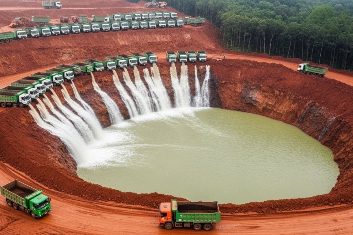
Survey Shows How Water at the Top of a Mountain, Pumped for Decades, Became a Calculated Risk: The Upper Reservoir in a Ring, Without an Outlet, on Unstable Rock, Failed on December 14, 2005. The Alert Letter Was Ignored, and the Flood Devastated 113 Hectares of the Black River and Forest
By tracking images and records of the site, how water at the top of a mountain left a mark that still shows up on Google Earth: on the slope of Profit Mountain, there is a crack 2.5 km long and 200 m wide, devoid of vegetation and showing no signs of recovery even after 20 years.
The trail of disaster points to a colossal volume, one billion gallons of water, plunging like a liquid explosion and uprooting trees. Along the way, a house was torn from its foundations and carried about 400 m, with the Tuper family, consisting of five people, surviving in extreme conditions after the flood.
The Visible Scar and the Question That the Terrain Poses

When following the trail of destruction, it becomes clear that it was neither a meteor nor a natural landslide. It was water at the top of a mountain falling from a great height, at a point without a natural basin below to absorb the flow in case of failure.
-
A forgotten cord on the floor of a basement in Vienna leads a plumber to a box containing 30 kilograms of gold with Mozart’s face, hidden before World War II. The treasure, worth 2.3 million euros, was just centimeters away from a worker who ignored the sign a day earlier.

-
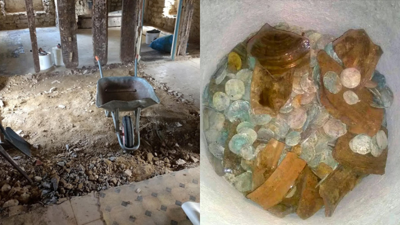
A couple buys an old chalet, breaks the kitchen floor for renovation, and finds over a thousand coins of gold and silver hidden since the English Civil War over 4 centuries ago.
-
Rigid bags with their days numbered: new trend prioritizes comfort in 2026.

-
YouTuber creates an excavator equipped with a giant 4.5-meter sword to challenge his brother to a rematch, and the invention quickly goes viral on social media.


What is most striking is the contrast between the evidence in the terrain and what occurred beforehand: there was a formal alert, there were operational signs, and yet the sequence of decisions kept the system functioning as if the mountain were just another component of the electrical grid.
The Pumped Storage Plant Created as a Giant Battery for the Electrical Grid
Between 1960 and 1963, the United States built the Taum Sauk pumped storage hydroelectric plant in the San Francois Mountains in Missouri.
The project was presented as a “giant battery” for the national electrical grid, with pump-turbines described as the largest manufactured in the country at the time and with the capacity for nearly automatic, remote-controlled operation.
The control centers were located up to 200 km away. In practice, this meant that water at the top of a mountain, in volumes of billions of gallons, could be managed without constant human presence on-site, supported by sensors and automation routines.
The Upper Reservoir in a Ring and the Fragilities That Remained Hidden
The most strange and dangerous point was in the upper reservoir. Instead of using a natural valley, as is the case with most pumped storage plants, an artificial ring of dams was built at the top, like walls joined together to contain a massive volume of water.
The problem lay in the base. Instead of solid continuous rock, there was weathered rock, unstable and vulnerable to infiltration.
The reservoir was lined with more than 7,000 concrete slabs, joined by rubber joints with a limited lifespan. A crack could allow water to seep in, expand, and compromise the structure.
There was an additional risk: there was no emergency spillway. If the level exceeded the limit, there was no safe drainage route.
The overflow would occur directly over the dam, placing water at the top of a mountain on a path of free fall.
When the Free Market Transformed Operation into Permanent Pressure
Initially, the plant operated about 100 days a year, within a pattern seen as efficient and safe. That changed with the emergence of the free energy market in the 1990s. The logic became to maximize profits: to pump when energy was cheap and release when the value was higher.
In a few years, the operation tripled to nearly 300 days a year, with almost two pumping cycles per day. The upper reservoir began to be filled and emptied continuously.
The signs appeared in sequence: streams of water at the base of the dam, cracks in the concrete joints, leaks in valves, and at the bottom of the intake system.
Stopping meant losing money, and the routine continued with water at the top of a mountain being pushed to the limit by the frequency of operation.
The Disaster Dress Rehearsal in September and the Ignored Formal Alert
On September 25, 2005, during an inspection of the upper reservoir, employees saw water overflowing the edge, forming a white curtain cascading down the slope.
The level had exceeded the safety limit. The pumps were shut down, and the level was reduced in time.
Just 48 hours later, on September 27, 2005, an operations engineer sent an official alert to superiors, stating that the mountain would be severely eroded by the work and would eventually give way, causing everything to tumble down the slope.
There was no emergency meeting, no inspection, no repairs, nor warning to the community below. Seventy-seven days later, the prediction came true.
Sensors, Software, and the Safety That Became “Theoretical”
The subsequent investigation pointed to a central element: the water level sensors. The glue that held one sensor came loose, the probe became tilted, and it began to register levels dozens of centimeters below the actual. As the water approached dangerously close to the edge, the system “believed” there was still space and continued pumping, keeping water at the top of a mountain above the limit without alarms halting operations.
The biggest shock was the realization that the company was already aware of the problem but did not replace the sensor. Instead, it adjusted the software to reduce alerts, avoiding shutdowns. The cited safety measure, a backup probe, was merely theoretical: connected but never tested. No reports were sent to federal authorities during this period.
The Morning of December 14, 2005, When the Reservoir Disappeared
On the morning of December 14, 2005, at 5:09 a.m., a first sheet of water exceeded the edge of the dam by about 30 cm, seemingly harmless. It was the start of the excavation process that separated concrete from rock and triggered domino effect collapses.
In less than 10 minutes, the flow turned into a torrent capable of uprooting entire trees and displacing boulders. At 5:34 a.m., just 25 minutes after the first overflow, the reservoir at the top of the mountain completely vanished. The entire volume, one billion gallons of water, plummeted down the mountain, with a maximum flow described as about 7,700 m³ per second, creating an unprecedented flood in Missouri history and solidifying the worst scenario of water at the top of a mountain out of control.
House Dragged, Unlikely Survival, and the Limited Reach of the Flood
Following the trail of the flood, rescue teams found the house torn from its foundations and carried about 400 m away. The Tuper family, consisting of five people, lived there to take care of the site. Everyone survived, including three children, one of whom was just 5 years old, found alive among rocks and broken logs, with body temperature dropping to dangerous levels.
There were no fatalities, and surrounding towns were far too distant to be hit by the flood, but the episode exposed a critical point: the tragedy was not a surprise, it was a foreseen and ignored failure, fueled by decisions that kept water at the top of a mountain in a risky condition.
The Devastated Ecosystem and the Effects on the Black River
The environmental consequences were described as devastating. About 113 hectares of forest were completely stripped, with tree canopies of hundreds of years being taken away like leaves covered in mud.
Even years later, vegetation had not regrown, and some areas became considered irrecoverable through natural regeneration.
The fauna was swept away by the flood, including birds, deer, squirrels, and small amphibians. Mud, sediments, and heavy metals carried by the water flowed down to the Black River, causing fish die-offs and altering micro-flows of the river, transforming aquatic habitats.
The assessment presented by an ecologist was straightforward: it was not just a flood, it was ecological shock, in minutes, erasing decades of ecosystem development, all due to water at the top of a mountain released abruptly.
Investigation, Fatal Failures, and the Blame Game
After the flood, a large-scale investigation was launched, involving experts from the Federal Energy Regulatory Commission and state safety officials associations.
Three failures were highlighted as fatal: design error from the very start, inaccurate measuring instruments, and unstable foundation.
Boreholes revealed that the foundation had more loose material than anticipated. Sections of the dam’s edge were over 60 cm below the design level, making the reservoir more dangerous than the system numbers indicated.
In 2004, when level sensors were replaced, the subsidence was not considered, and the system continued believing that water at the top of a mountain was at a safe level.
Internal documents indicated opposition from some engineers to the original design, with warnings about weak foundations and the risk of subsidence.
One engineer reported that he had signed an alert that was disregarded. The owning company, Interstate Power and Light, was pointed out as being aware of defective sensors without reporting the issue, conduct that lawyers associated with a possible serious violation of the law.
Nevertheless, when civil actions advanced, the outcome was uneven: fines totaled 15 million dollars, while estimated damages reached one billion dollars, with much of the losses falling on residents and insurers.
Rebuilding from Scratch and What Changed in Safety
The final report determined that Taum Sauk should be rebuilt from scratch. About two years later, the old reservoir was dismantled without reusing components.
Instead of the earthen and rock structure subject to subsidence, a roller compacted concrete dam was built, a technology described as highly stable, with double the height and triple the width of the original structure.
The safety system was redesigned. Automated emergency spillways, multipoint sensors for pressure monitoring, radars to detect real-time displacements, and an early warning system connected to federal authorities were installed.
The phrase I heard repeatedly in the technical report sums up the leap: the old dam had a pair of eyes, the new one has hundreds.
The total cost of reconstruction reached about 500 million dollars, largely covered by insurance. Approximately 6 million tons of rock left by the flood were reused to fill and stabilize the foundation.
On February 27, 2010, the reservoir began to be refilled in tests, with centimeter-by-centimeter monitoring.
On April 1, 2010, the Federal Energy Regulatory Commission authorized the resumption of normal operations, placing water at the top of a mountain under a regime of much stricter control and redundancy.
The Global Alert and the Contrast with a Safer “Twin”
The case was not presented as isolated. The report mentions over 300 pumped storage hydroelectric plants in operation worldwide, with reservoirs suspended in mountains storing large volumes of water above communities.
The text outlines “near disasters” and extreme examples. In 2017, the Oroville Dam in California experienced serious spillway failures, with accelerated erosion and the evacuation of 188,000 people in 48 hours.
And, as the worst-case scenario mentioned, the Banqiao Dam in China, in 1975, ruptured in a chain reaction after extreme rains, with 26,000 immediate deaths and a total estimate of 171,000 victims, including indirect effects.
As a counterpoint, the Ludington Pumped Storage Power Plant, on the shores of Lake Michigan, has been in operation since 1973. The upper reservoir is about 840 acres, approximately 2.5 miles long and 1 mile wide.
The project mentions flatter terrain and a more stable foundation, as well as protective structures and screens to prevent fish entry during specific periods.
The plant has six reversible turbines, each capable of raising or lowering the water level by about 30 cm per hour, with flexibility to meet peaks equivalent to 1,700,000 households. The original cost was 327 million dollars, compared in the report to nearly 27 billion in current values.
In your opinion, what was the most serious failure in this case of water at the top of a mountain: the project without an outlet, the management of the sensors, or the decision to ignore the formal alert?


-

-

3 pessoas reagiram a isso.