 Portuguese
  English
  Spanish
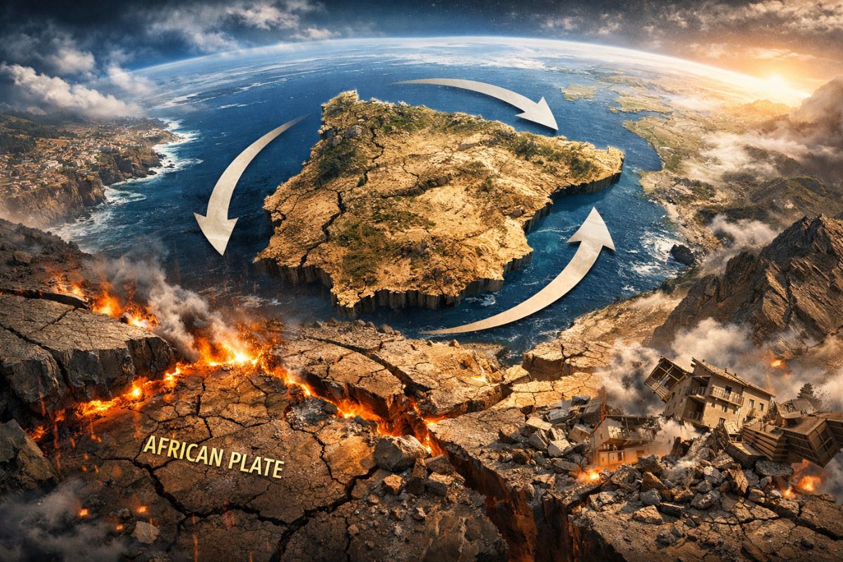
Although They Seem Immobile on the Atlas, Portugal and Spain Are Subject to Continuous Tectonic Pressure Caused by the Approach Between Africa and Eurasia, in a Slow, Asymmetric, and Geologically Relevant Process That Deforms the Crust, Redistributes Tensions, and Helps Explain Why the Iberian Peninsula Is Far from Being Static.
Portugal and Spain Are at the Center of a Discovery That Changes the Way We View the Apparent Stability of the Iberian Peninsula. What Maps Show as a Fixed Continental Mass Is Actually Subject to a Very Slow Clockwise Spin, Caused by the Accumulated Pressure Between the African and Eurasian Plates.
This Movement Is Subtle Enough Not to Be Perceived in Daily Life, but Significant Enough to Interest Geology, Seismology, and Studies on Crustal Deformation. This Is Not a Sudden Rotation or a Change Visible to the Naked Eye, but rather a gradual process that Has Been Altering Internal Tensions in the Earth’s Crust Across a Complex Area of the Western Mediterranean.
A Study Shows That the Iberian Peninsula Does Not Function as an Immobile Block
The Main Conclusion Presented by the Researchers Is That the Iberian Peninsula Does Not Behave Like a Rigid and Completely Stopped Structure. Instead, It Gradually Responds to the Tectonic Forces Acting in the Region Where the Eurasian and African Plates Come Together. This Continuous Push, Although Small in Annual Terms, Produces Relevant Effects When Analyzed on a Geological Scale.
-
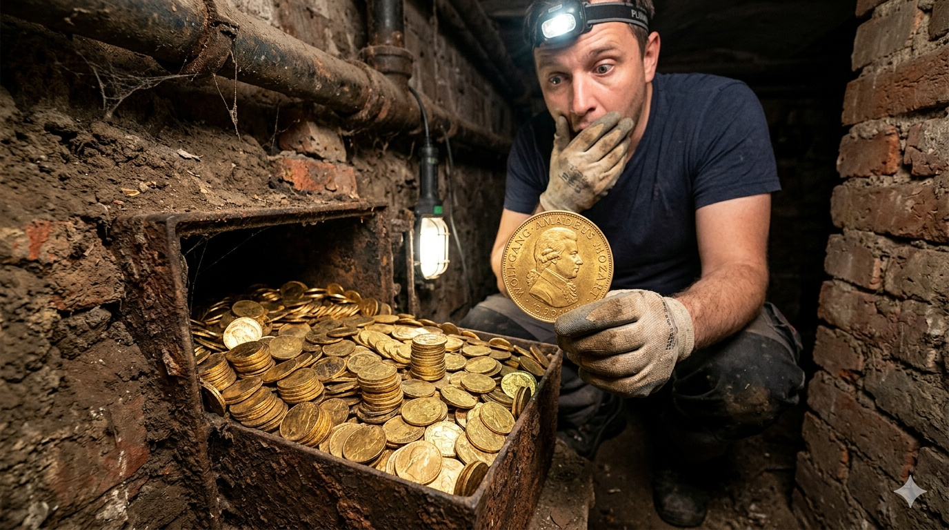
A forgotten cord on the floor of a basement in Vienna leads a plumber to a box containing 30 kilograms of gold with Mozart’s face, hidden before World War II. The treasure, worth 2.3 million euros, was just centimeters away from a worker who ignored the sign a day earlier.
-
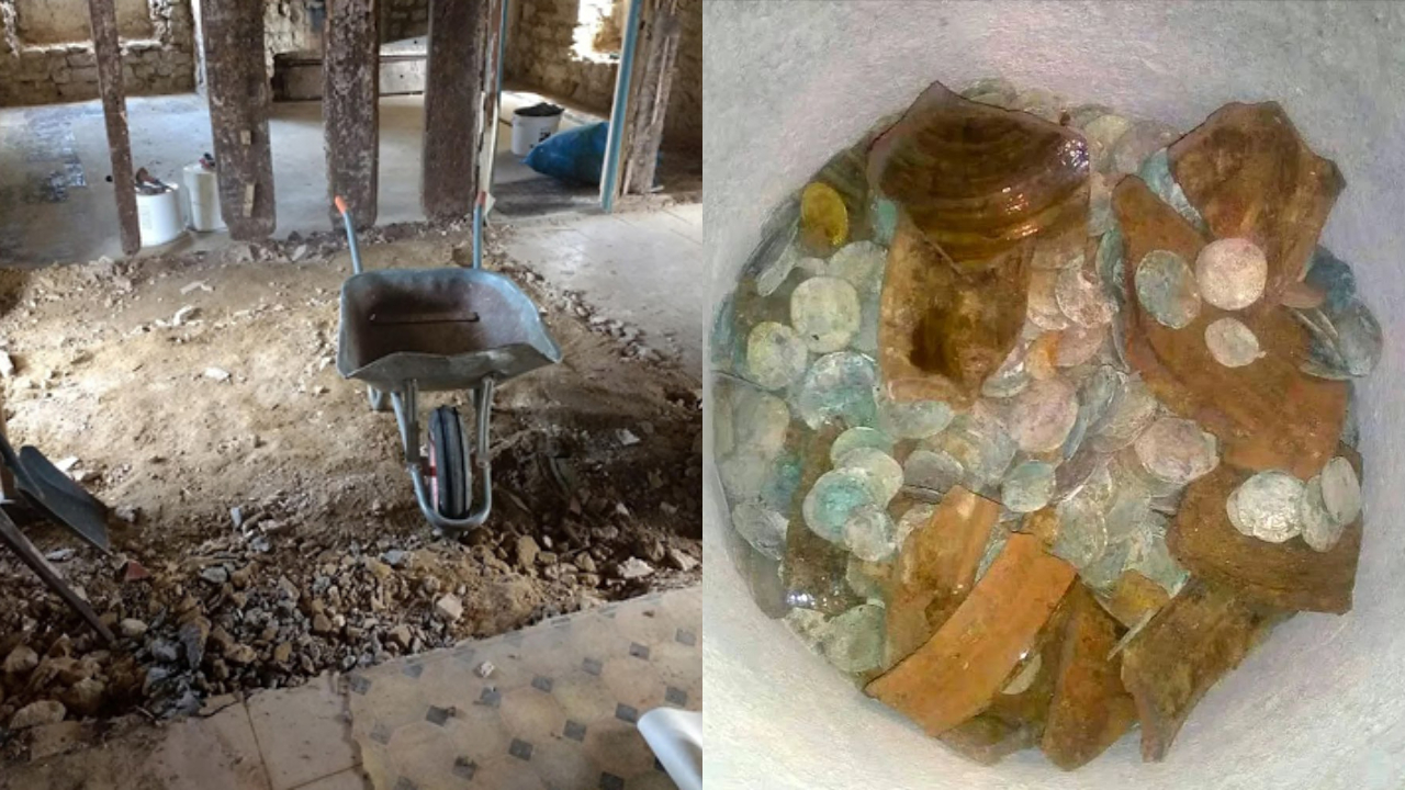
A couple buys an old chalet, breaks the kitchen floor for renovation, and finds over a thousand coins of gold and silver hidden since the English Civil War over 4 centuries ago.
-
Rigid bags with their days numbered: new trend prioritizes comfort in 2026.

-
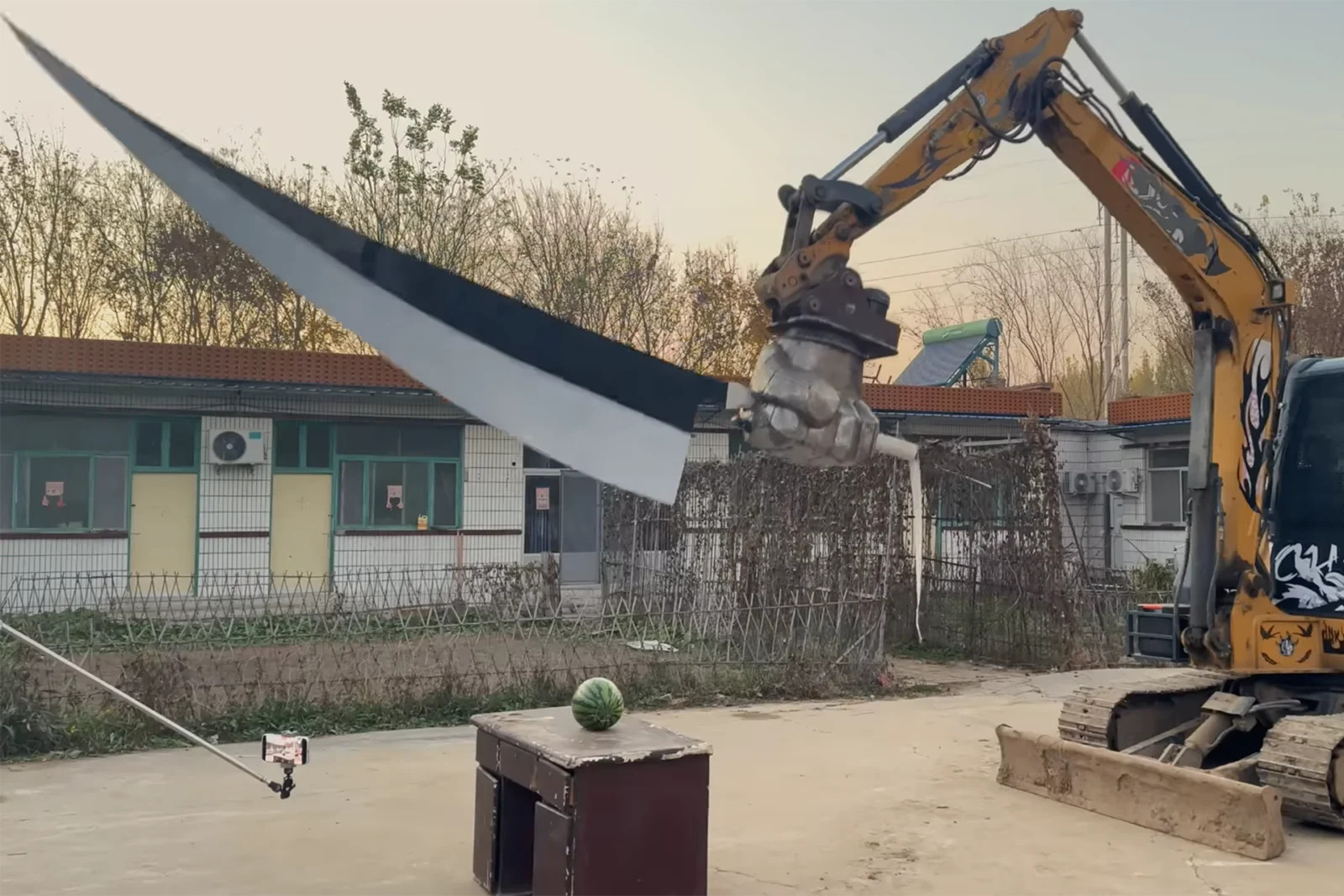
YouTuber creates an excavator equipped with a giant 4.5-meter sword to challenge his brother to a rematch, and the invention quickly goes viral on social media.

The Idea That Portugal and Spain Slowly Rotate About Themselves Helps Translate a Technical Phenomenon into More Understandable Terms. The Clockwise Direction Indicated in the Study Does Not Mean That the Countries Are “Spinning” Like a Loose Object, but That the Crustal Mass of the Region Experiences Deformations and Displacements Consistent with a Slow Rotation, Associated with Tension Transmission from Tectonic Collision.
This Understanding Alters a Common Perception of the Region’s Geography. The Stable Appearance of the European Relief Might Suggest Immobility, Yet the Earth’s Crust Is in Constant Transformation, Even at Very Low Rates. When Scientists Detect Displacements of a Few Millimeters Per Year, They Are Not Observing an Irrelevant Detail, but a Precise Signal of the Planet’s Internal Functioning.
Therefore, the Discovery Has Scientific Weight. It Reinforces That Portugal and Spain Are Embedded in an Active Tectonic Zone, Marked by Distributed Pressures, Slow Deformations, and Geological Structures That Do Not Always Appear Clearly or Linearly on Traditional Maps.
The Pressure Between Africa and Eurasia Explains the Detected Movement
At the Center of This Dynamic Is the Convergence Between the African and Eurasian Plates, Described in the Study as Occurring at a Speed of 4 to 6 Millimeters Per Year. It May Seem Like a Small Amount, but This Range Is Sufficient to Accumulate Tensions Over Long Periods. In Geology, Nearly Imperceptible Movements in the Present Can Represent Significant Changes Over Thousands and Millions of Years.
The Compression Generated by This Approach Does Not Distribute Uniformly. According to the Explanation Provided by the Researchers, the Area South of the Iberian Peninsula Does Not Have a Simple, Straight, and Clearly Defined Boundary. This Means That Tectonic Energy Does Not Concentrate in a Single Easily Identified Fault, but Spreads Across a Broader and More Complex Zone.
It Is This Complexity That Helps Explain Why Portugal and Spain Do Not Respond Like a Rigid Block. The Pressure Reaching the Region West of the Strait of Gibraltar Exerts Enough Force to Push the Peninsula and Favor This Gradual Clockwise Spin. In Other Words, Deformation Does Not Occur Randomly or By Chance: It Is a Direct Consequence of How Tensions Are Being Transmitted Through Plate Collision.
This Is a Crucial Point for Understanding the Study. We Are Not Just Talking About Movement, but About the Mechanism That Produces That Movement. The Relationship Between Africa, Eurasia, and the Iberian Peninsula Shows That Regional Geodynamics Depends on a Continuous Game of Forces, Where the Crust Absorbs, Redistributes, and Reveals Tectonic Pressure Slowly but Measurably.
From the Gulf of Cadiz to the Alboran Sea, Deformation Forms a Wide and Diffuse Zone
One of the Most Important Aspects of the Research Is the Description of the Area Where This Deformation Occurs. Instead of a Single and Obvious Trace, Like in More Well-Known Tectonic Faults, the Analyzed Zone Extends from the Gulf of Cadiz to the Alboran Sea. It Is an Extensive Belt, Marked by Dispersed Fractures, Asymmetric Movements, and Significant Structural Complexity.
This Helps Explain Why the Tectonic Boundary in the South of the Iberian Peninsula Is Considered Diffuse. There Is No Clear, Distinct Line There Separating Tensions and Displacements. What Exists Is a Set of Distributed Structures That Interact With Each Other and Influence the Behavior of the So-Called Gibraltar Arch, One of the Most Relevant Areas for Understanding Regional Tectonics.
This Configuration Differentiates the Region from More Didactic Scenarios, Where a Major Fault Concentrates Movement and Facilitates Geological Interpretation. In the Case of Portugal and Spain, the Picture Is More Delicate. Tectonic Efforts Are Transmitted Through a Fragmented Architecture, Where Different Areas of the Crust Respond Unequally to the Same General Pressure.
This More Refined Reading Is Fundamental Because It Shows That the Deformation of the Iberian Peninsula Cannot Be Summarized to a Single Fracture or a Single Point of Rupture. The Study Suggests a Much More Complex System, Where the Crust Slowly Adjusts, Accumulating Signs of Movement in Different Areas and Requiring Integrated Analysis for a Consistent Understanding of the Process.
Satellites and Seismic Records Allowed Measuring an Almost Invisible Movement
To Reach These Conclusions, Scientists Combined Information Obtained by Satellite With Seismic Records. This Integration Was Essential Because the Observed Deformation Is Extremely Slow, and No Isolated Set of Data Would Be Sufficient to Deeply Explain What Is Happening in the Earth’s Crust in the Region.
The GNSS Stations, Based on High-Precision Global Positioning, Play a Central Role in This Type of Investigation. They Can Detect Very Small Displacements, on the Order of a Few Millimeters Per Year. In Tectonic Phenomena, This Minimum Scale Is Exactly Where the Most Valuable Information Lies, As It Reveals Continuous Trends That, Although Subtle in the Short Term, Indicate Real Transformations in the Behavior of the Crust.
At the Same Time, Seismic Records Help Interpret How Tensions Are Distributed and How the Region Internally Responds to Plate Compression. Earthquakes, Even When Not Devastating, Function as Clues About How Accumulated Energy Organizes and Releases. When These Data Are Read Alongside Geodetic Measurements, the Tectonic Picture Becomes Much Clearer.
This Cross-Referencing of Evidence Strengthens the Credibility of the Analysis. It Shows That the Slow Spin Attributed to Portugal and Spain Is Not a Loose Hypothesis but an Interpretation Built on Different Layers of Observation, Gathered to Overcome Limitations and Broaden Understanding of the Geological Dynamics in the Western Mediterranean.
The Time of Geology Is Much Greater Than the Time of Modern Records
Another Critical Point of the Study Lies in the Difference Between the Time of Available Data and the Time When Geodynamic Changes Actually Occur. The Researchers Highlight That Accurate Earthquake Records Date Back Only to 1980, While Precise Satellite Data Begins in 1999. This Represents a Short Window Compared to Processes That Develop Over Millions of Years.
This Limitation Imposes a Significant Methodological Challenge. How Can Slow and Deep Movements Be Interpreted Based on Relatively Recent Time Series? The Answer Found by Scientists Was to Integrate Different Types of Information, Seeking to Extend the Reading of Tectonic Behavior Beyond the Isolated Reach of Each Data Set.
The Difficulty Does Not Diminish the Importance of the Discovery; On the Contrary, It Makes the Result Even More Relevant. Successfully Identifying Trends of Deformation in a Short Observation Interval Requires Technical Precision, Analytical Consistency, and an Interpretive Model Capable of Linking the Present to Long-Term Geological Processes.
In the Case of Portugal and Spain, This Means That the Signals Measured Today Should Not Be Seen as a Fleeting Episode, but as Part of an Extensive Tectonic History. The Detected Movement Is Too Slow to Alter People’s Routines, But Not Slow Enough to Escape Science. It Is Precisely in This Interval Between the Imperceptible and the Measurable That the Study Gains Strength.
The Accumulated Tensions May Reveal Faults That Are Not Yet Fully Mapped
The Analysis of Tension Fields Conducted by the Researchers Also Points to Another Important Consequence: The Possibility of There Being Tectonic Structures That Are Not Yet Completely Identified. In Some Areas of the Iberian Peninsula, Significant Deformations Have Been Observed, Even Though the Exact Faults Responsible for These Movements Are Not Fully Mapped.
This Shows That the Geology of the Region Still Holds Areas of Uncertainty. Not Every Observed Deformation Can Be Accurately Associated With a Known Structure. Scientifically, This Opens Space for New Investigations, Cartographic Revisions, and Deepening of the Tectonic Models Used to Interpret Crustal Behavior in the South and Southwest of the Peninsula.
The Existence of Faults That Are Not Fully Characterized Does Not Mean That the Territory Is on the Brink of Abrupt Transformation, but Indicates That Available Knowledge Is Still Under Construction. The More Detailed the Mapping, the Greater the Ability to Understand How Tensions Propagate, Where They Accumulate, and How They Influence Regional Seismic Risk.
This May Be One of the Most Important Developments of the Study. By Showing That Portugal and Spain Are Part of an Active and Complex Tectonic Dynamic, the Research Not Only Describes a Slow Movement, but Also Expands the Scope of Questions About the Deep Architecture of the Iberian Peninsula and About Structures That Still Need to Be Better Understood.
The Advancement of Mapping Helps Understand Regional Seismic Risk Better
The Study Also Holds Practical Utility for Assessing Seismic Risk. When Researchers Can Identify Active Faults, Deformation Zones, and Patterns of Tension Transmission, They Provide Valuable Elements to Understand Where the Crust Is More Likely to Accumulate Energy and How That Energy May Behave Over Time.
Regions Such as the Western Pyrenees and the Strip Between Cádiz and Seville Appear as Particularly Relevant in This Context. Not Because the Study Is Announcing an Imminent Event, But Because They Are Areas Where Detailed Understanding of Deformation Can Improve the Reading of Existing Geological Hazards. Better Understanding Tectonic Structure Is an Important Step Towards More Accurately Assessing Vulnerabilities.
This Type of Information Interests Not Only the Scientific Community but Also Land Use Planning, Engineering, and Monitoring Policies. In Tectonically Complex Regions, Prevention Depends Heavily on the Quality of Available Knowledge. The Clearer the Map of Tensions and Active Faults, the Better the Ability to Responsibly Interpret Future Scenarios.
In the Case of Portugal and Spain, the Central Message Is Clear: The Apparent Stillness of the Iberian Peninsula Does Not Eliminate Its Internal Activity. On the Contrary, the Study Reinforces That the Visible Stability of the Landscape Coexists with Deep, Slow, and Persistent Forces That Continue to Shape the Earth’s Crust Without Drawing Attention Beyond Laboratories and Research Centers.
What Appears Immobile on Maps May Be in Continuous Transformation
One of the Most Interesting Dimensions of This Discovery Is the Contrast Between Perception and Reality. For Those Observing a Map, the Iberian Peninsula Appears Fixed, Consolidated, and Unchanging. But Geology Operates on Another Scale, Where A Few Millimeters Per Year Are Sufficient to Reconfigure Tensions, Deform Structures, and Reveal That the Territory Is Far from Being Completely Static.
Portugal and Spain Thus Represent a Clear Example of How the Earth’s Surface Combines Apparent Stability with Deep Dynamism. The Crust Does Not Need to Break Spectacularly to Be in Motion. In Many Cases, It Changes Almost Silently, Recording in Its Structure the Persistence of Ancient and Still Active Tectonic Forces.
This Also Changes the Way We Interpret the European Space. Instead of a Closed Geological Landscape, the Iberian Peninsula Appears as a Sector in Evolution, Linked to Greater Processes Involving the Western Mediterranean, the Gibraltar Arch, and the Interaction Between Large Tectonic Plates. The Study Broadens the Notion of Continuity Between Relief, Seismicity, and Deformation.
This Is the Weight of the Discovery: It Makes an Invisible Process Visible. By Showing That Portugal and Spain Slowly Rotate Clockwise, the Researchers Are Not Only Describing a Technical Detail but Revealing a Deep Dynamic That Helps Reinterpret the Very Idea of Territorial Stability.
In the End, This Discovery Shows That Portugal and Spain Are Far from the Immobility Suggested by Maps and Continue to Respond, at a Slow Pace, to the Tectonic Forces Acting Beneath the Iberian Peninsula. Did You Imagine That Such a Discreet Movement Could Be So Important for Understanding the Earth’s Crust?
Let Us Know in the Comments if This Explanation Changes Your View of the European Territory and How the Planet Continues to Transform Even When Everything Seems Still.


-

Uma pessoa reagiu a isso.