 Portuguese
  English
  Spanish
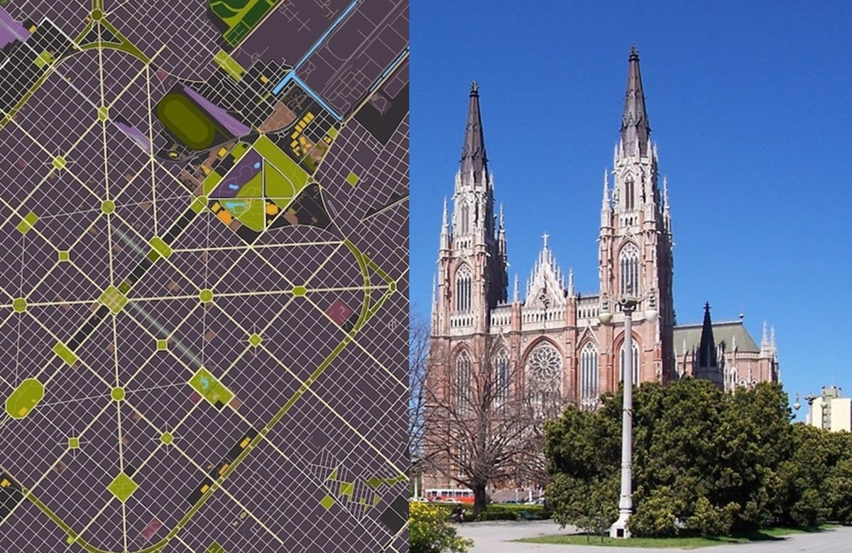
With Mathematically Precise Layout, Streets Crossing at Right Angles and Diagonally Positioned, the Argentine City Features Squares Every Six Blocks, Parks Harmoniously Distributed, and a Monumental Neo-Gothic Cathedral Dominating the Heart of the Planned Capital.
La Plata is the capital of Buenos Aires Province in Argentina, and was born as a planned city to fulfill this administrative function after the federalization of Buenos Aires in 1880.
Founded on November 19, 1882, by the then-governor Dardo Rocha, La Plata became a classic case of rational urbanism in the Southern Cone — a condition that is documented in reference sources.
Political Origin and Foundation
The decision to create a new provincial capital stemmed from the Argentine institutional rearrangement at the end of the 19th century: when Buenos Aires was federalized as the national capital (1880), the province lost its administrative seat and opted to build a city from scratch to house it.
-
The Argentine government celebrates the lowest poverty rate in 7 years, but experts warn that the methodology has changed, real wages have fallen, unemployment has risen, and the number of people on the streets of Buenos Aires has increased by 57% since Milei took office.

-
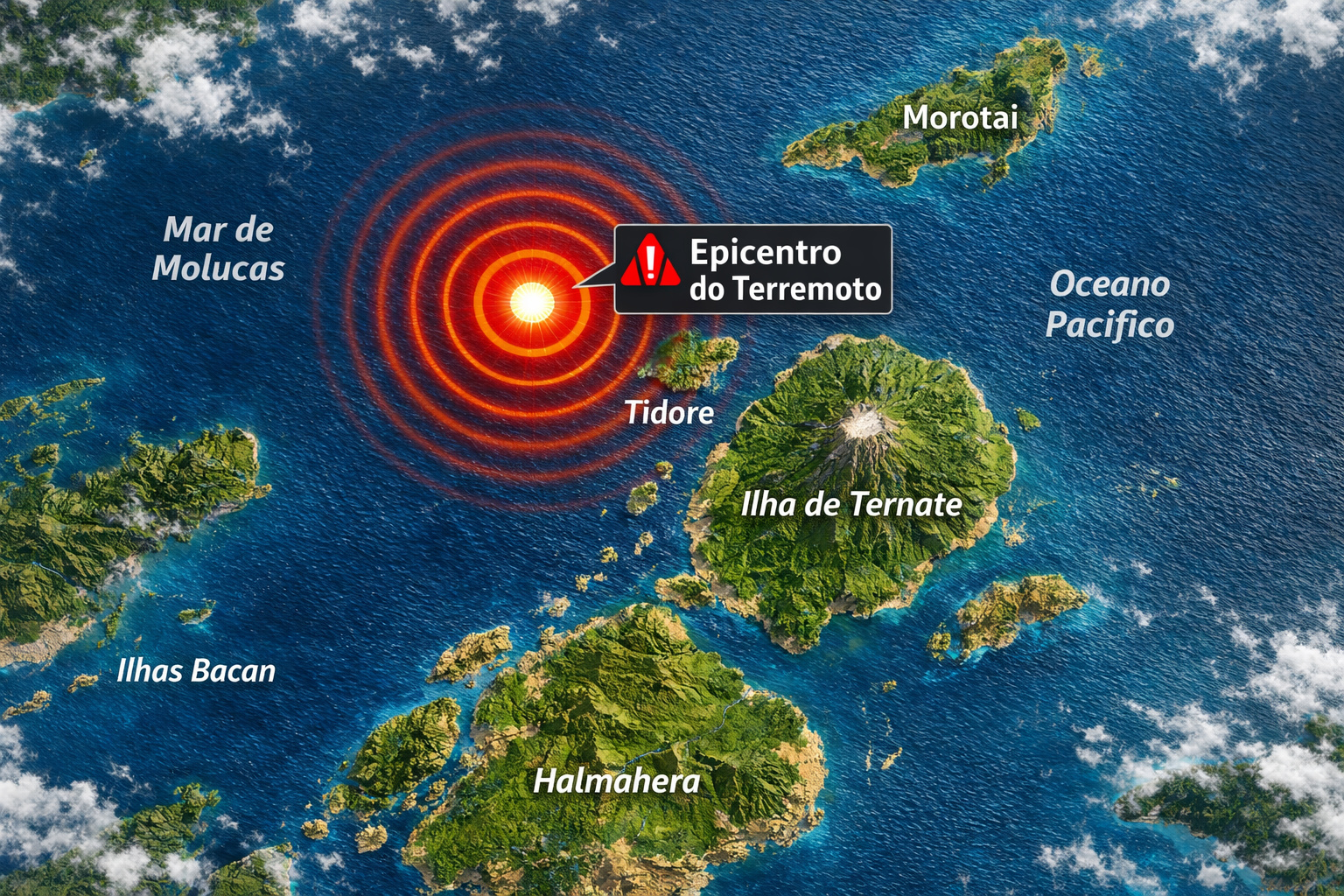
7.8 magnitude earthquake in Indonesia frightens the population, triggers tsunami alert, and hits an island with over 200,000 inhabitants this Thursday.
-
Google will finally let you change that embarrassing Gmail address you created in your teenage years without losing any accounts, logins, or old emails: the feature is already available in the United States.

-
Heading to Brazil in a Bonanza F33 single-engine aircraft: a couple departs from Florida on a visual flight, makes technical stops in the Caribbean to refuel and organize paperwork, and begins the staged crossing until they reach the country.


Dardo Rocha himself chose the site and led the initiative that culminated in the official foundation on November 19, 1882.
Reference sources also record that La Plata was conceived as a coherent urban plan from the beginning, with photographic documentation of its construction and, later, a brief name change to “Ciudad Eva Perón” between 1952 and 1955 — another indication of the city’s symbolic and administrative character.
The Plan by Pedro Benoit: Orthogonal Grid + Diagonals
The urban design was entrusted to architect and engineer Pedro Benoit, widely recognized as the author of La Plata’s layout.
The plan combined an orthogonal grid (streets and avenues crossing at right angles) with diagonals that cut through the city and shorten travel distances, a feature that earned La Plata the nickname “city of diagonals.”
Specialized literature and encyclopedic references point to Benoit as the one responsible for this unique urban arrangement.
The most widely accepted international comparison in general sources is that the plan took as a model planned capital cities, and Encyclopaedia Britannica explicitly records a conceptual kinship with Washington, D.C. — that is, a capital designed with a view towards government functions and spatial ordering from its inception.
Civic Center: Plaza Moreno, City Hall, and Cathedral
At the heart of the grid, La Plata organizes its main civic symbols around the Plaza Moreno. This central square serves as an urban hub and brings together, facing each other, two landmarks: the Municipal Palace (City Hall) and the La Plata Cathedral. The Cathedral — in neo-Gothic style — rises at the geographic center of the city, facing the square and the local government seat, forming a civic-architectural axis that synthesizes the original intent of the plan.
Visitor reports and local guides reinforce the centrality of Plaza Moreno, describing it as the point where one can see the “square” (grid) structure of the city and where the symmetrical logic of the layout is clearly perceived.
Network of Green Areas: The Rule of Squares Every Six Blocks
A frequently cited element by researchers and heritage entities is the regularity of green areas. Academic studies and urban preservation institutions describe La Plata as a city where squares and green spaces appear at a constant rate, with green areas every six blocks in the foundational sector — a principle that defined a landscape of tree-lined avenues and small parks spread throughout the grid.
This distribution is not merely aesthetic: it mirrors the search, in the 19th century, for healthier and more organized cities, consistent with the administrative function and with circulation facilitated by planned axes. Although peripheral expansion has, over time, stressed the homogeneity of this design, the original core remains recognized for its green regularity and the clear reading of the plan.
Recognition and Urban Legacy
The combination of an orthogonal grid, diagonals, rhythmically placed squares, and a central civic axis makes La Plata a recurring case in manuals, guides, and international promotional materials. Encyclopedias, cultural guides, and reports from international media highlight the city as an example of an administrative seat conceived entirely as a project — a characteristic that sustains its interest for architects, urban planners, and visitors.
This legacy is not only reflected in form: La Plata housed, from the beginning, institutions of knowledge and culture (such as observatories, museums, and a municipal library) integrated into the plan, reinforcing the city’s role as capital and educational hub of the province.
Contemporary Challenges: The 2013 Flood as a Milestone
Like other planned cities of the 19th century, La Plata faces challenges of contemporary urbanization, metropolitan expansion, and extreme climatic events.
On April 2 and 3, 2013, an episode of exceptional rainfall caused severe flooding. The official numbers for the city of La Plata were judicially consolidated and confirm 89 loss of lives resulting from the disaster — a widely reported figure by international flood monitors.
Considering the metropolitan area (Greater La Plata), encyclopedic sources in English indicate 91 fatalities reported, an important methodological distinction between the municipal perimeter and the metropolitan cut.
Journalistic reports from that time already pointed to dozens of fatalities and characterized the severity of the event, which became a turning point in the local debate about drainage, risk, and preparation for hydrometeorological extremes.
The stratification of numbers over the following days — with official updates — helps to explain why some of the initial reports mentioned lower totals (in the “dozens”), before the final consolidation adopted by the Justice system.
What is Solidly Confirmed About La Plata
Purposefully Created Provincial Capital: La Plata was planned and built to be the capital of Buenos Aires Province, after the federalization of Buenos Aires (1880). It was officially founded on November 19, 1882.
Unique Layout: orthogonal grid combined with diagonals; a recurring characteristic in descriptions of the city.
Civic Center: the Plaza Moreno links the city hall and the La Plata Cathedral (neo-Gothic), located at the geographic center facing the square.
Regular Green Areas: technical literature points to green areas every six blocks in the foundational sector and networks of open spaces as hallmarks of the plan.
Extreme Event of 2013: 89 confirmed deaths for the city of La Plata; 91 reported for Greater La Plata according to an English encyclopedic source.
Note About What Is Not Confirmed (and Therefore Was Omitted)
This text does not use specific numerical indicators of “quality of life” (such as 133.85; 116.77; 93.94) or detailed percentages of green space (“21%”) or commuting habits (“40% walk daily”), as we did not find, in reliable sources, public studies that precisely support these values for La Plata and its comparisons.
We also avoided attributing a direct and documentarily proven influence of Auguste Comte on the city’s design, although the spirit of the 19th century and planned capitals serve as a general context in reference works. (See referenced sources throughout the text.)
In summary, La Plata remains a remarkable example of a planned capital: born from a clear political decision, materialized in a geometric layout with diagonals and a network of regular squares, established a symbolic civic center at Plaza Moreno with the neo-Gothic Cathedral and, at the same time, faces contemporary dilemmas that test the resilience of any historical city.
What distinguishes it — and this remains confirmed — is the strength of a legible urban plan, capable of telling, through the lines of its grid, the very story of its foundation and its role in Argentina.


-

-

-

-

-

-

70 pessoas reagiram a isso.