 Portuguese
  English
  Spanish
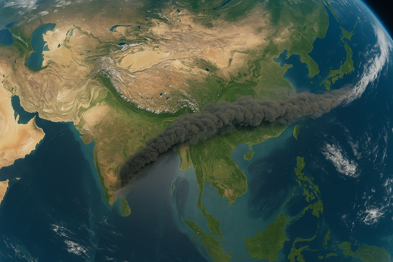
Record Made by Sentinel-5P Shows Movement of Ash Cloud Between Africa and China, Revealing Direct Impact on Aviation and Reinforcing Security Alerts
The Sentinel 5-P satellite, part of the Copernicus System, recorded the extensive ash cloud produced by the eruption in Ethiopia, whose plume traveled over 6 thousand kilometers between Africa and China. The record, obtained through the SO₂ sensor, highlighted the accelerated movement of the ash at different altitudes.
Eruption in the Afar Rift and Movement of the Ash Plume
The eruption of the Hayli Gubbi volcano, located in the remote region of the Afar Rift, released a large amount of ash that quickly crossed the Red Sea, advanced through the Arabian Peninsula, reached India, and later arrived in China, covering over 6 thousand kilometers. The volcano, which had no recent activity records, erupted on Sunday and sent ash between 8.5 km and 15 km altitude, a critical range for international air traffic.
Impact on Aviation and Operational Adjustments
The effects were immediate. Airports in India reported cancellations, delays, and rerouted flights, particularly affecting flights to the United Arab Emirates. Air India canceled at least 11 flights, while IndiGo, Akasa Air, KLM, and other airlines needed to adjust operations due to the presence of the cloud on strategic routes. The movement of the particles forced aircraft to avoid contaminated areas.
-
It looks like a movie scene: “Forgotten” Brazilian city surprises with a waterfront of nearly 11 km, tranquil beaches, and a GDP that exceeds R$ 6 billion; meet Navegantes, in Santa Catarina.

-
Milei’s government launches surprise police operations on the streets of Argentina to hunt undocumented immigrants, but the government’s own data reveals that only 4% were irregular. Critics say it is a copy of Trump’s policy without real necessity.

-
Indonesia is the largest producer of tropical seaweed in the world, and this market is already worth billions of dollars, but 90% of the production goes directly to China as raw material. Now the country wants to change the game and process everything on its own.

-
This extremely contagious virus has already affected 90% of the population of Brazil and has no cure.

Rerouting and Unplanned Landings
Among the changes, an IndiGo flight from Kannur to Abu Dhabi had to land in Ahmedabad to avoid the area affected by the ash concentration. SpiceJet also delayed takeoffs and revised routes due to adverse conditions identified by aviation monitoring centers.
Security Alerts Issued by Authorities
The Directorate General of Civil Aviation of India issued security alerts. Thus, the authorities reinforced protocols to protect engines and sensors. Additionally, they highlighted the possibility of power loss during flight. However, meteorologists stated that the ash at lower altitudes was minimal, which reduced concerns about air quality.
Meteorologists’ Assessment and Associated Risks
Meteorologists explained that the low concentration of ash in the lower atmosphere layers decreased risks to the population. Moreover, the analysis reinforced that the main impacts were on international air routes. Therefore, rerouting became essential to avoid damage to aircraft.
Similar Episodes and Aviation Vulnerability
The episode reinforces aviation’s vulnerability to major eruptions. Additionally, experts recall the case of the Eyjafjallajökull volcano in Iceland in 2010. At that time, the ash cloud caused air disruptions in Europe for several days. Therefore, similar events continue to require intense monitoring.


-

-

2 pessoas reagiram a isso.