 English
  Francês
  Alemão
  Italiano
  Japonês
  Norueguês
  Portuguese
  Spanish
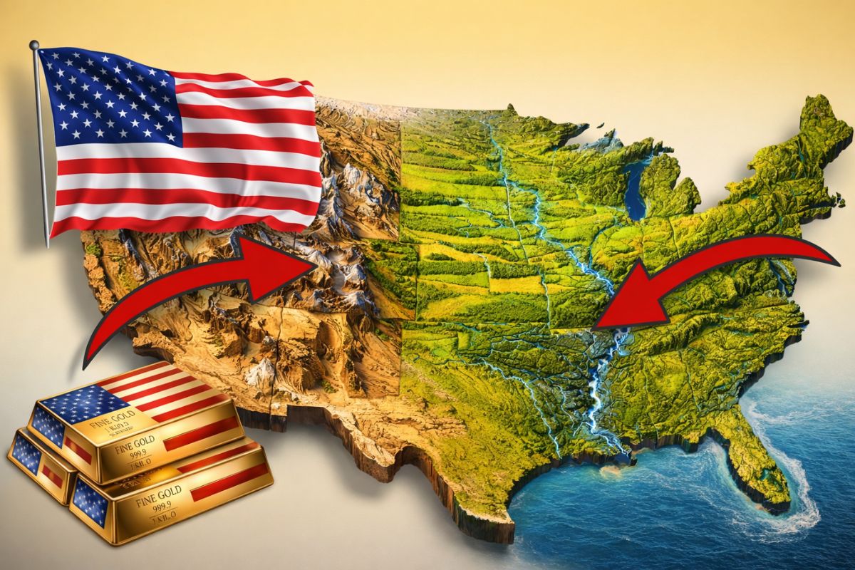


In The United States, The Combination Of Integrated River Basin, Fertile Plains, Protected Ocean Outlet, And Geographic Isolation Created A Rare Structural Advantage Capable Of Reducing Transport Costs, Expanding Production, Reducing Military Vulnerabilities And Sustaining Wealth Accumulation For Generations, Even With Political Crises And Economic Cycles Over Decades Of Successive.
The United States are often explained by politics, technology, and the market, but the material basis of this power starts on the map. Before Wall Street And Large Corporations, there is a geography that connects production, circulation, and security on a continental scale in a way that few countries have managed to gather in the same territory.
When observing the physical layout of the country with coldness, the question changes form. Instead of asking only who worked better, it becomes important to know where the rivers are, how much it costs to transport a ton, why the borders are more defensible, and how this generates an advantage that spans centuries.
The River System That Transforms Territory Into Economic Network

The central point of this advantage lies in the Mississippi system and its tributaries, treated here not as an isolated river, but as a vascular structure.
-
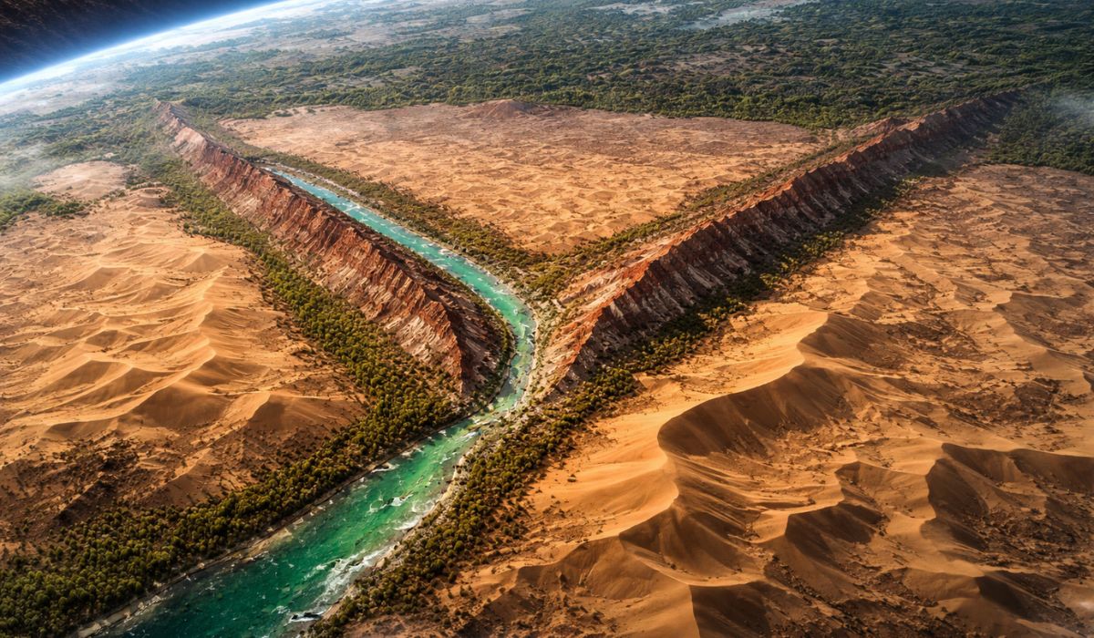
Seen from space, a colossal ‘Y’ cuts through the largest desert in China, blending a jade-filled river, red and white mountains, and revealing the absurd scale of the transformation of the Taklamakan surrounded by a green wall with billions of trees.
-
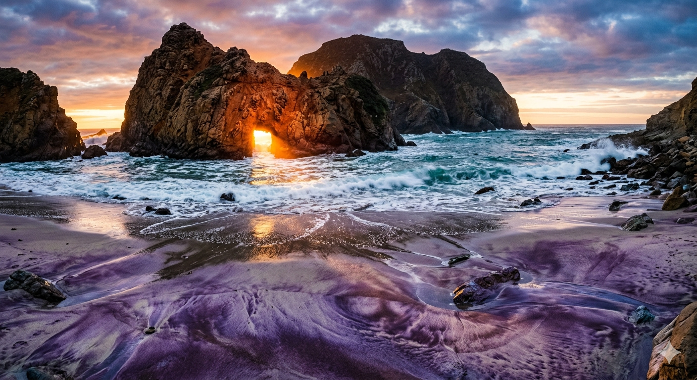
The Pacific Ocean reveals what the cliffs of Big Sur have hidden for millennia: Pfeiffer Beach, in California, features swirling purple sand formed by garnet crystals and displays a stone arch that is illuminated by the sun in winter for just a few days each year.
-
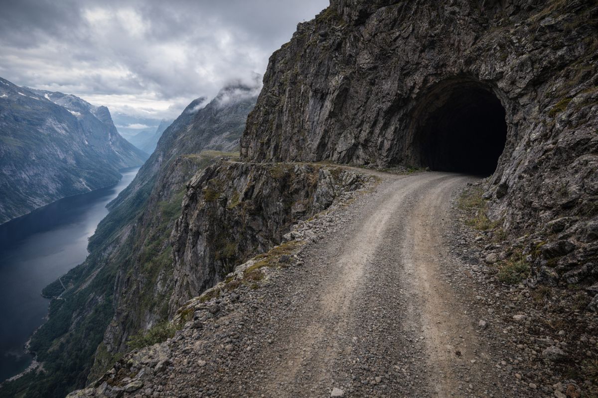
Aursjøvegen in Norway is a 100-kilometer gravel road that crosses chasms and dark tunnels carved into the rock at an altitude of 947 meters in the fjords and is only open for four months a year.
-
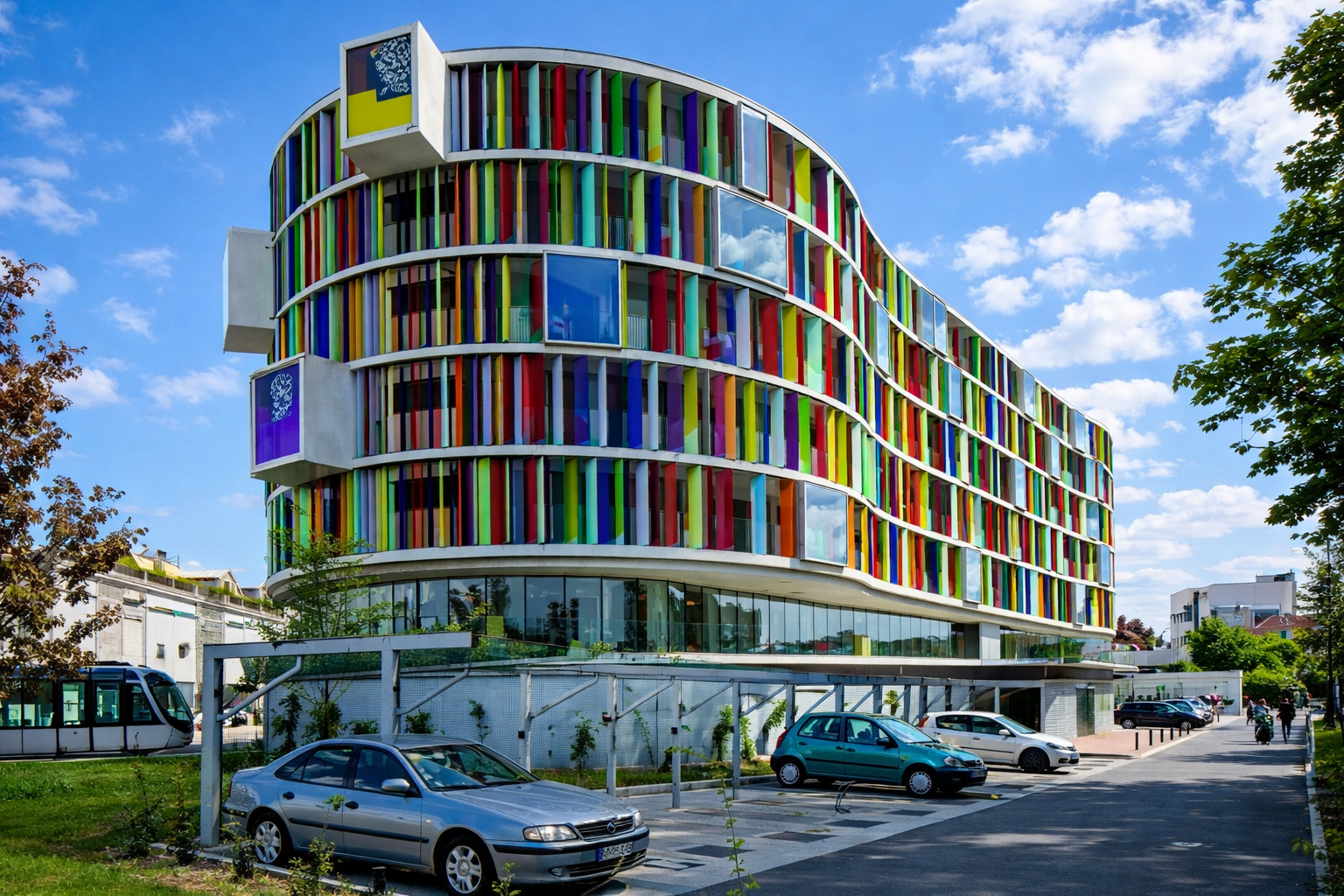
With about 4,000 m², the building constructed in a traditional neighborhood in France looks like a rainbow, has a colorful facade, mixes vibrant glass, and creates one of the most unusual visuals in Bordeaux.

Mississippi, Missouri, Ohio, Arkansas, Tennessee, and Red River emerge as a web that links distant productive areas via the same natural road, allowing different regions to economic communicate without having to rely solely on expensive constructions from the start.
This network drains and connects 31 states and 41 percent of the continental territory of the United States. In practice, this means that producers, miners, and industrial hubs scattered throughout the interior can access a continuous network of cargo circulation, with rare territorial integration compared to countries that have large rivers but are disconnected from each other.
The decisive detail is the topography. The basis presented describes the Midwest with a smoother topography, calmer waters, and fewer violent interruptions, favoring the navigation of barges over long distances.
Instead of a sequence of natural barriers, rivers become navigable corridors that reach the interior and reduce transshipment stages.
Another strategic element is the convergence towards a single outlet in the Gulf of Mexico through New Orleans. This geography forces integration, creates a funnel for drainage, and concentrates wealth from the interior in an accessible exit to global trade.
It’s not just the presence of rivers, it’s the alignment among rivers, the direction of flow, and the point of connection with the sea.
Cheap Transportation And Capital Accumulated At A Faster Pace

The economy of transportation helps explain why this geography weighs so much. According to the provided basis, moving a ton by water can cost 10 to 30 times less than by truck.
When this difference repeats over decades in grains, wood, minerals, and other heavy volumes, the accumulated effect on margins and investment becomes a structural advantage.
In the United States, navigable rivers pass through precisely agricultural and industrial production regions, which reduces the economic distance between origin and market.
Those who produce near navigable rivers and ship on a large scale spend less to compete, preserve capital, and can reinvest sooner in machinery, expansion, and complementary infrastructure.
The comparison with other countries, within the base, reinforces the contrast. Brazil has giant rivers, but most of them are not aligned with the main industrial and agricultural center in the Southeast.
Russia has extensive rivers; however, it faces freezing and flow directions that are less useful for constant commercial integration. In the United States, 24,000 km of natural waterways appear in the right place on the map.
This combination helped accelerate capital accumulation in the 19th and 20th centuries. While other economies needed to spend fortunes to build difficult routes in less favorable environments, the United States already had a natural transportation infrastructure that functioned as a permanent initial advantage.
The geography reduced costs even before any brilliant political decision.
Fertile Lands, Climate, And Abundance As Strategic Power
Efficient rivers only generate full power when there is something to transport, and the basis highlights that the Midwest concentrates one of the largest contiguous bands of high-quality arable land in the world.
The description of the ice age is important because it explains the origin of this fertility on a continental scale, with glaciers leveling the terrain and leaving deep layers of rich soil.
It is in this space that agricultural belts such as corn and wheat consolidate, in states like Iowa, Illinois, Kansas, and Nebraska.
The combination of fertile lands and river logistics creates a rare synergy because production and transportation grow together. The countryside is not isolated from circulation; it is born connected to commercial output.
The climate also factors into this equation. The basis describes a temperate zone that avoids cold extremes like in Russia and reduces some of the humidity and pest problems associated with more aggressive tropical environments.
Add to this the meeting of cold air from Canada and humid air from the Gulf of Mexico, generating regular rain cycles in decisive agricultural areas.
This abundance has a geopolitical effect. Countries with chronic food insecurity need to protect import routes or manage greater internal vulnerability.
The United States, on the contrary, appear with superabundance and the capacity to export at lower costs thanks to the rivers. Food, geography, and transportation form a block of power, not separate sectors.
Two Neighboring Oceans And An Uncommon Continental Security
The geographical analysis does not stop at production. It extends to the physical security of the continental territory. To the east and west, the Atlantic and Pacific Oceans act as large-scale natural barriers, complicating land invasion projections and reducing the historical defense pressure from the productive heart.
This relative isolation altered the economic trajectory of the United States because factories and central areas did not suffer the same routine of destruction and reconstruction that marked parts of Europe in recurring wars.
When the productive territory remains intact for long periods, the country preserves capital, industrial continuity, and planning capacity.
To the north, Canada appears in the base as an economic partner rather than a military threat, with tough geography and a population concentrated near the border.
To the south, the border with Mexico is marked by deserts and difficult terrain, which increases the complexity of any large-scale invasion movement. The result is a power with less pressure on land borders than continental rivals.
This does not eliminate strategic challenges, but it broadens the scope for maneuver. While other powers expend political and financial energy on tense borders, the United States can direct more resources to trade, industry, and innovation.
Geographical security acts as an invisible subsidy because it reduces costs that elsewhere are permanent.
Protected Coast, Secure Internal Route, And Energy As Final Piece
A less remembered detail, but highlighted in the base, is the presence of barrier islands along the East Coast and the Gulf of Mexico. They create an inland waterway with calmer waters between the coast and the open ocean, forming a protected maritime corridor for internal cargo circulation.
During World War II, this geographical layout allowed more protected internal movements, including ships avoiding direct exposure at sea in sensitive sections.
It’s another layer of logistical resilience, showing that the advantage of the United States lies not in a single river or a single plain, but in a set of geographical fits.
For decades, energy has appeared as a point of vulnerability due to dependence on oil imports. The basis states that the shale revolution altered this picture, revealing large reserves of oil and natural gas in areas like the Permian Basin in Texas and the Bakken formation, reinforcing autonomy and production capacity.
With rivers, fertile lands, oceans, coastal routes, and energy, the geography of the United States gains a rare density of overlapping advantages.
Even with political errors, financial crises, and internal conflicts, the physical structure continues pushing the country forward with cheap food, efficient transportation, and relative security of the continental territory.
Geography Does Not Decide Everything, But Increases The Margin Of Error
The basis does not treat geography as magic or as an eternal guarantee of supremacy. Politics, culture, and economic decisions still matter, and favorable geography can be wasted by poor choices.
Still, when a country accumulates so many natural advantages in the same space, the margin for error becomes much larger than that of rivals with more difficult maps.
This is the point that makes competition so unequal. It’s not just about current productivity or cutting-edge technology, but about a physical system that reduces transportation costs, sustains wealth, protects the territory, and integrates agricultural and industrial production from the start.
In geopolitical terms, the United States plays on a terrain that already delivers bonuses before the first government decision.
That’s why the idea of competing on equal footing with the United States hits a material barrier. To surpass this power, it’s not enough to copy institutions or invest more in a specific sector.
It’s necessary to confront limits of geography, relief, climate, rivers, and oceans that no decree can redraw in the short term.
Still, understanding this advantage is useful precisely to avoid simplistic explanations. When recognizing the weight of geography, it becomes clearer where public policies can compensate for real disadvantages and where international comparisons turn into empty propaganda.
The map does not explain everything, but it explains more than much analysis admits.
The strength of the United States does not arise solely from the market, military power, or national narrative. It relies on a rare fit between navigable rivers, fertile lands, cheap transportation, protective oceans, and a territorial integration that reduces costs, preserves capital, and transforms geography into wealth over long historical cycles.
If you had to choose the most decisive factor in this advantage of the United States, which would weigh more for you in the long run: navigable rivers, fertile lands, oceans as barriers, or the combination of cheap transport and continental security, and why?


Nosso BRASIL é assim também, pena q esse malditojeitoPTde governar destrói tudo isso!
No Brasil o que atrapalha não são os rios, relevo, etc, são os políticos e a insegurança jurídica.. para dar certo teria que renovar todo o sistema judiciário, onde seria obrigatório concurso público para ser membro do STF.
Claro enquanto as ongs impedem de o Brasil usar seus rios fica esse impasse.