 Portuguese
  English
  Spanish
Santa Catarina Will Experience the Impact of Two Extratropical Cyclones Between Wednesday and Friday, With Forecasts of Heavy Rain, Isolated Storms, Hail, and Wind Gusts of Up to 100 km/h, Mainly Between the Coast, Greater Florianópolis and Hill Areas
The weather forecast indicates the formation of a first system offshore this Wednesday, associated with a cold front, capable of causing localized rain showers and storms throughout the day. This first episode has moderate potential for impact but already requires attention in areas more susceptible to strong wind and heavy rain. According to the NSC portal, the second extratropical cyclone, expected for Friday, will be closer to the coast and, therefore, has a greater capacity to generate strong winds, hail, and lightning, affecting a large part of the state during the day.
The forecasted extratropical cyclones are part of a typical spring configuration in Southern Brazil, where colder air masses advance over the continent and meet warm, moist air still present over Santa Catarina. This contrast favors the formation of storms and wind gusts in a short period. The Santa Catarina Civil Defense recommends that the public follow official warnings and avoid exposure in risk areas during periods of greater instability.
What to Expect From the First Extratropical Cyclone
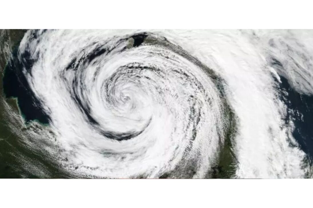
The first of the extratropical cyclones forms offshore and acts more indirectly over Santa Catarina.
-
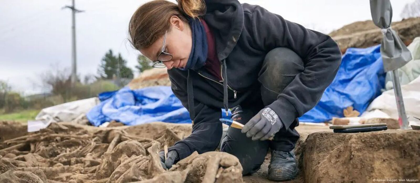
Remains with battle wounds of over 100 soldiers from the Roman Empire are found beneath a football field in Vienna, leaving everyone surprised.
-
Elon Musk notes Brazil and lowers the price of his internet, Starlink, promising to connect all corners of the country with affordable plans, 10,000 satellites, and 1 million active users in the national territory!

-
Man creates an infinite source of FREE electricity at home with a PVC wind turbine using a repurposed motor.

-
An aquatic seed consumed for centuries in Asia is going viral in the West after studies highlighted its antioxidant compounds and potential anti-inflammatory properties. It pops like popcorn, has low fat content, and is already being called the new functional snack.


Even so, the presence of a cold front associated with the system increases the availability of humidity and instability, especially between the Southern Plateau, Southern Coast and Greater Florianópolis.
In these areas, Wednesday tends to have more concentrated rain between late morning and late afternoon, with the possibility of isolated storms.
Since this first extratropical cyclone is farther from the coast, it should not cause extreme winds over the state, but it may still channel moderate gusts in coastal areas and hillside regions.
The scenario is one of localized alerts, not widespread damage, but it already indicates that the atmosphere will be more dynamic throughout the week.
Friday Will Have the Stronger System
The second of the extratropical cyclones is the one that requires the most attention. The forecast indicates formation over land, a less common and more dangerous situation because it brings the center of the system closer to populated areas.
In this context, wind gusts may reach 80 km/h in coastal areas and up to 100 km/h in higher, exposed regions, like the Santa Catarina Serra.
When the extratropical cyclone operates very close to the coast or over land, the effect is not only of wind. The combination with the cold front advancing across the South of the country favors heavy rain in a short period, occurrence of lightning, and hail.
This type of event can cause roof damage, falling branches, localized power outages, and difficulties for navigation and activities in open waters. Therefore, the recommendation is to reduce unnecessary travel during hours of greater instability.
Areas and Periods Most Vulnerable
Monitoring agencies indicate that hillside areas between the Southern Plateau and the Southern Coast, as well as Greater Florianópolis, should be monitored more closely. These locations usually record more intense rain due to their topography and may have channeled gusts.
On Friday, with the extratropical cyclone closer, the risk extends to other regions of the state, as the system is expected to move in from Rio Grande do Sul throughout the day.
The most critical period tends to be during the passage of the cold front associated with the extratropical cyclone. At this stage, the clouds gain vertical development and can produce storms at any hour, not being solely dependent on the heating of the early afternoon.
It is important for the public to be attentive even during the early hours of the day and not just in the late afternoon, when they usually expect rain showers.
Safety Measures Recommended by Civil Defense
On days with the action of extratropical cyclones and forecasts of strong gusts, the main recommendation is to avoid taking shelter under trees, as there is a risk of falling branches and also lightning strikes. This advice applies to those traveling by car as well.
Vehicles should not be parked near signs, high walls, power poles, and transmission towers, as these points become more susceptible to wind.
During episodes of heavy rain, the recommendation is not to cross flooded areas, bridges, and submerged walkways. Flooding can conceal holes, currents, and loose materials that compromise safety.
At home, it is advised to unplug devices during thunderstorms with lightning and to securely close doors and windows to prevent winds from causing internal damage.
Checking the registered email or mobile number in alert services also helps react more quickly if risk levels increase.
Climate Context of the Week
Before the arrival of the second extratropical cyclone, Santa Catarina is still experiencing high temperatures and a feeling of stuffiness, with maximums above 28°C in several regions and up to 33°C in the West.
This prior warming is one of the factors that amplify the storms, as it provides energy for the clouds to develop more quickly. Thus, the breakdown of stability on Friday tends to be more abrupt.
The succession of heat, humidity, and the advance of cold fronts is a well-known pattern in the South of the country and typically requires consecutive days of observation.
Even after the system passes, Saturday may still have many clouds and rain throughout the day, with gusts that may exceed 80 km/h in some areas. In other words, the environment does not return to complete stability immediately after the peak of the event.
The occurrence of two sequential extratropical cyclones increases the risk of strong winds, storms, and localized disruptions in Santa Catarina, especially on Friday when the system will be closer to the mainland.
Following the Civil Defense’s recommendations, avoiding risk areas, and monitoring the forecast throughout the day are actions that reduce damage and preserve safety.
Now tell us in the comments if in your city the wind tends to cause more problems than rain and how you usually prepare when there’s a storm alert.


Seja o primeiro a reagir!