 English
  Francês
  Alemão
  Italiano
  Japonês
  Norueguês
  Portuguese
  Spanish
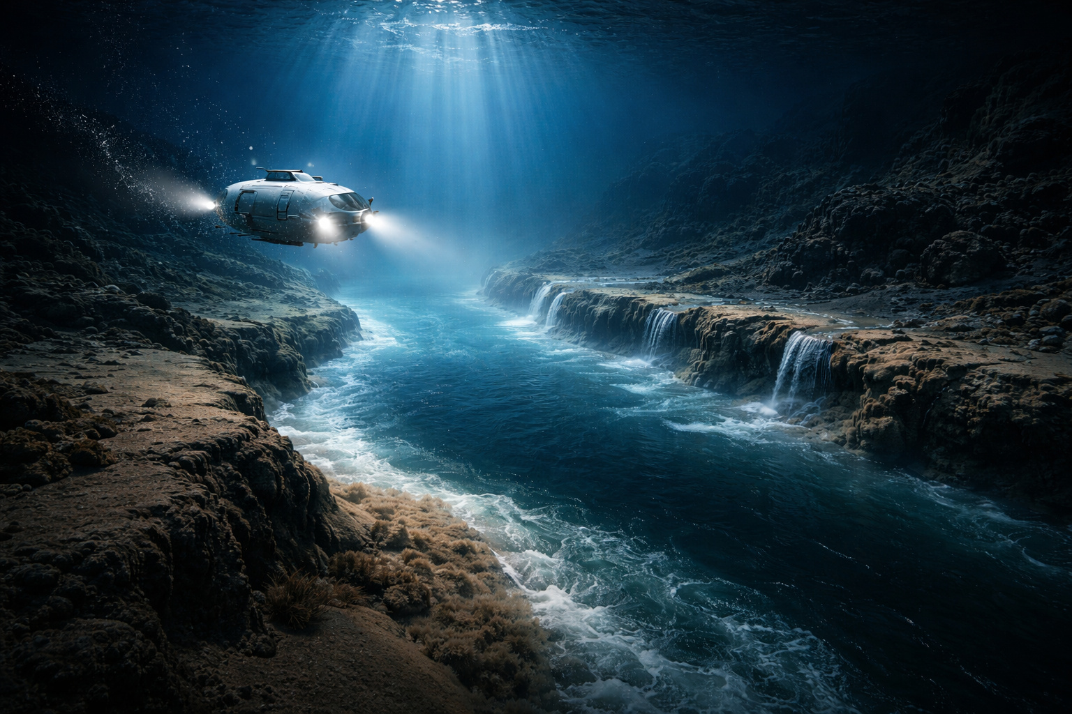
Autonomous submarine reveals river at the bottom of the Black Sea with 22,000 m³/s, waterfalls, and active flow shaped by density differences.
The ocean floors hide channels that geologists have been mapping for decades with sonar. What no one had been able to confirm was a simple question: do these channels have water flowing through them like a river on land, or are they just static grooves in the sediment? In 2010, a team from the University of Leeds led by researchers Dan Parsons and Jeff Peakall sent an autonomous submarine to the bottom of the Black Sea to answer this question directly. What they found was a real river: with banks, floodplains, waterfalls, and a flow of 22,000 cubic meters of water per second, 350 times the volume of the River Thames.
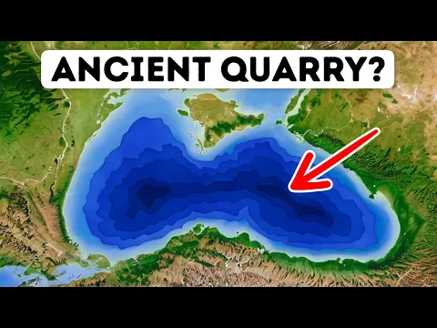
River at the bottom of the sea: the submarine channel of the Black Sea that intrigued geologists
Marine geologists have been mapping the bed of the Black Sea with sonar since the 1990s. The data revealed a long channel with well-defined edges that originated in the Bosporus Strait and extended for dozens of kilometers towards the deeper regions.
The shape was clearly identified, but there was an essential gap. The maps did not indicate whether there was active flow within this channel or if it was just a geological remnant of long-finished processes.
-
350-year mystery may have been solved: remains of a soldier who inspired the hero of The Three Musketeers found beneath a church in the Netherlands.

-
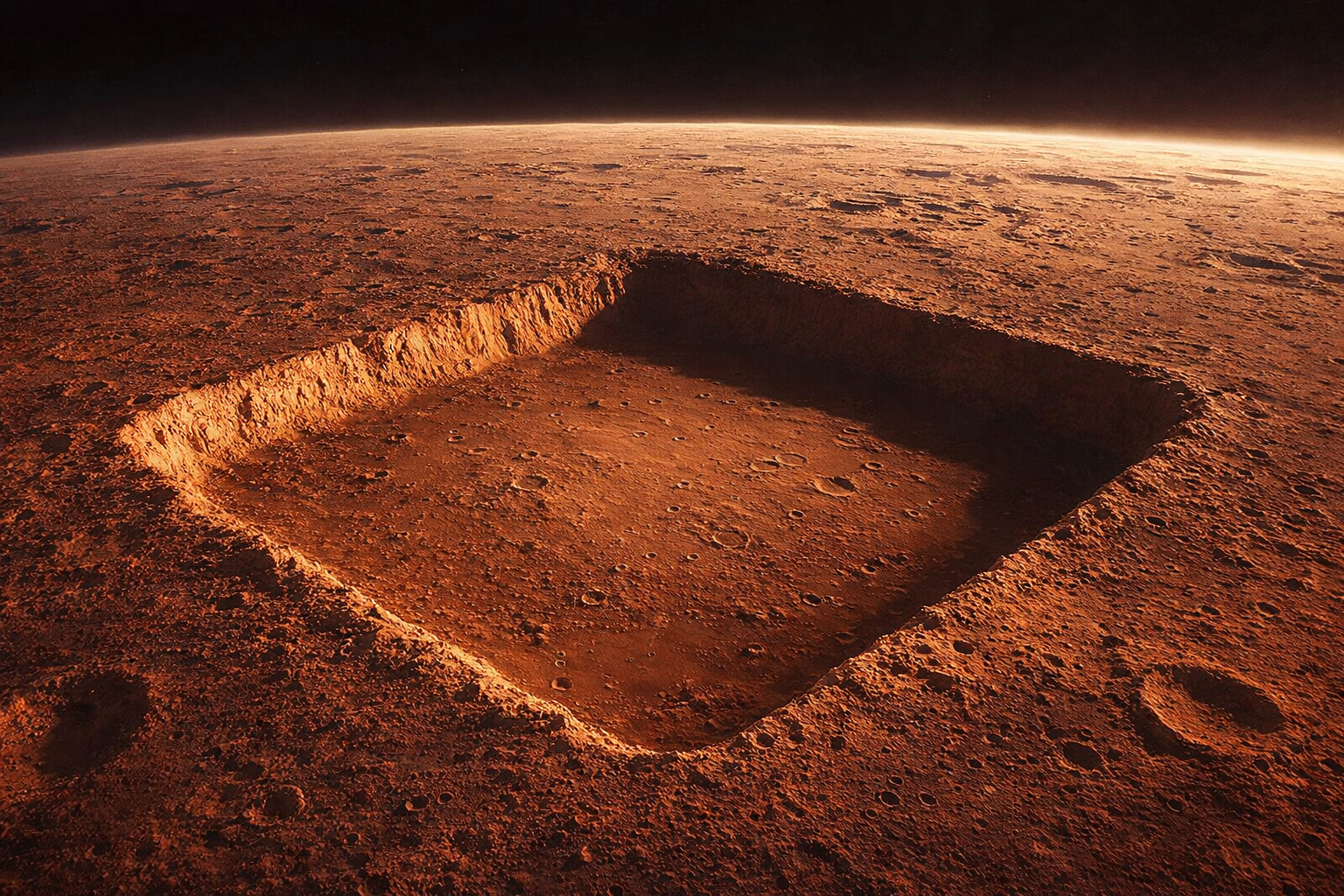
NASA photographed a nearly perfect square with 3 km sides on Mars, 13 times larger than the Great Pyramid of Giza, but the official explanation is natural erosion; still, no one has explained why the four sides have almost identical lengths.
-
Starlink breaks the barrier of 10,000 satellites in orbit and takes its expansion to an unprecedented level, with a direct impact on global internet, technological competition, and the race for space.

-
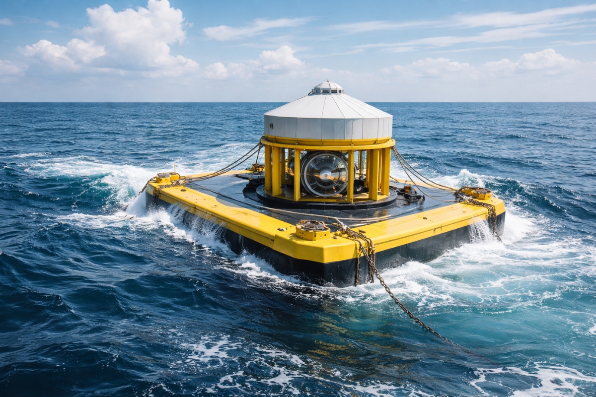
Japan finds an alternative to oil amid rising prices by transforming ocean balance into electricity with a new technology that maintains efficiency even when the sea changes.

This distinction is critical. An active channel transports sediments, redistributes nutrients, continuously alters the ocean floor’s topography, and can pose risks to underwater structures. An inactive channel, on the other hand, is just a static geological feature.
Answering this question required direct measurements inside the channel, something that only became possible with the advancement of autonomous underwater vehicles.
How a submarine river works: water density and currents at the bottom of the ocean
The idea of a river running at the bottom of the sea seems contradictory, but it is explained by fundamental physical differences between water masses.
The water entering the Black Sea through the Bosphorus Strait comes from the Mediterranean and has much higher salinity. The Black Sea, on the other hand, receives a large volume of freshwater from continental rivers, resulting in lower salinity.
This difference creates a density gradient. The Mediterranean water, saltier and heavier, sinks upon entering the Black Sea. As it descends along the slope of the underwater terrain, it begins to flow as a bottom current, maintaining its structure and speed.
This flow forms channels, erodes banks, creates bends, and even underwater waterfalls. The behavior is analogous to that of a river on land, but occurs within another fluid.
The autonomous submarine that confirmed the river at the bottom of the Black Sea
The equipment responsible for the discovery was the Autosub3, an autonomous underwater vehicle approximately 7 meters long, developed by the Natural Environment Research Council of the UK.
Programmed to operate without direct connection to the surface, the submarine was sent to navigate just a few meters above the channel, collecting detailed data on the speed, direction, and salinity of the current.
Before this mission, knowledge about the channel was based solely on sonar images. The Autosub3 allowed, for the first time, to directly measure the internal flow.
The data revealed speeds of up to 1.2 meters per second and a total flow of 22,000 cubic meters per second. The channel had well-defined banks, with a depth of up to 35 meters and an approximate width of 1 kilometer, extending about 60 kilometers before dissipating into deeper areas.
What the submarine river transports: sediments and nutrients at the ocean floor
The current of the channel does not only transport saltwater. It carries large volumes of sediments, including sand, mud, and organic matter.
This transport has a direct impact on deep marine ecosystems. Abyssal plains, characterized by low nutrient availability, receive organic material through these flows, sustaining life forms that depend on this energy input.
Moreover, the mechanism helps explain the formation of large submarine channel systems in other regions of the planet, such as those associated with the mouth of the Amazon River, which extend for hundreds of kilometers into the Atlantic Ocean.
Origin of the submarine river: 7,500 years of continuous flow in the Black Sea
The submarine river of the Black Sea has existed for approximately 7,500 years. Its formation is directly linked to the rise in Mediterranean sea levels after the last glaciation.
When the sea level rose, the Mediterranean began to overflow through the Bosporus Strait, establishing a permanent connection with the Black Sea, which was previously a freshwater lake.
This event created a two-layer circulation system: freshwater flowing at the surface towards the Mediterranean and saltwater entering from the bottom towards the Black Sea. Over millennia, this continuous flow sculpted the submarine channel, creating defined banks and structures similar to those of land rivers.
Differences between land rivers and submarine rivers: flow dynamics and sedimentation
Despite structural similarities, the physical behavior of a submarine river differs significantly from that of a river on land.
In the underwater environment, the flow occurs within another fluid, which alters the dynamics of the currents. In bends, for example, the velocity distribution is inverted compared to land rivers, with higher speeds near the bed.
Additionally, there is no direct influence from rain, evaporation, or seasonal variations, making the flow much more stable over time.
Impact on the oil and gas industry: risks and submarine planning
The discovery has direct implications for the deep-water oil and gas industry. Submarine channels are responsible for transporting sediments that, over millions of years, form hydrocarbon reservoirs. However, active currents can compromise structures such as pipelines, anchors, and platforms.
The data collected by the Autosub3 allowed the development of more accurate three-dimensional models, now used in underwater engineering planning for various projects around the world.
The Black Sea channel represents only a small sample of a much larger system. Currently, about 74% of the ocean floor has yet to be mapped with sufficient resolution to identify similar structures. This indicates that submarine rivers may exist in various still-unknown regions.
The Black Sea channel was confirmed as active not because it is the largest, but because it is in an area accessible for exploration with available technology.
The role of the Bosporus Strait in the formation of the submarine river
The Bosporus Strait functions as a hydrodynamic control system between the Black Sea and the Mediterranean.
Approximately 31 kilometers long, it supports a bidirectional flow: freshwater at the surface towards the Mediterranean and saltwater at the bottom towards the Black Sea.

This deep flow maintains its identity upon entering the Black Sea, forming the submarine channel before slowly mixing with the surrounding waters.
The separation between the water masses is maintained by density differences caused by salinity. The denser Mediterranean water remains at the bottom, flowing as a distinct body. The mixing with Black Sea water occurs only at the edges of the channel and gradually.
This phenomenon is known as underflow, or bottom current, and is fundamental to the stability of the system.
Submarine currents and ocean physics: the phenomenon of turbidity currents
The process is classified as a turbidity current or underwater gravity current. The greater density of the water, combined with transported sediments, keeps the flow adhered to the bed and accelerates its movement in sloped areas.
When the channel reaches deeper regions, the transported material is deposited, forming structures known as submarine fans.
The discovery in the Black Sea expanded the interpretation of geological formations beyond Earth. Mars features extensive channels whose origin is still debated. The physics of density currents offers an alternative explanation for some of these structures.
On Titan, Saturn’s moon, there are channels formed by liquid methane. On Europa, Jupiter’s moon, a subsurface ocean may harbor similar currents. These environments suggest that the phenomenon observed in the Black Sea may be common in other celestial bodies.
After the initial mission in 2010, new expeditions were conducted in 2013 with multiple research vessels, deepening the understanding of the channel structure, sediment transport, and associated marine life.
One of the most relevant discoveries was the presence of biological communities adapted to the specific conditions of the saline and dense flow.
The Black Sea remains one of the main natural laboratories for studying submarine currents, offering clues about processes that shape the ocean floor on a global scale and that are still far from being fully understood.


Seja o primeiro a reagir!