 Portuguese
  English
  Spanish
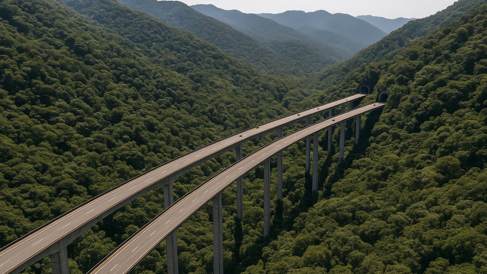


Iconic Highway Stands Out Internationally for Uniting Advanced Engineering, Safety, and Rare Integration with the Atlantic Forest, Creating One of the Most Impressive and Studied Highway Routes in Brazil.
One of the main connections between the city of São Paulo and the coast, the Imigrantes Highway (SP-160) has transformed from a simple route to an international reference in road engineering.
In a stretch of about 20 kilometers of mountain, the road crosses the Atlantic Forest supported by viaducts that reach approximately 70 meters in height, combined with wide and gentle curves that help reduce risks on foggy and rainy days.
The Imigrantes is part of the Anchieta-Imigrantes System and connects the Metropolitan Region of São Paulo to the Baixada Santista, heading towards cities like Santos, São Vicente, and Praia Grande.
-
The Argentine government celebrates the lowest poverty rate in 7 years, but experts warn that the methodology has changed, real wages have fallen, unemployment has risen, and the number of people on the streets of Buenos Aires has increased by 57% since Milei took office.

-
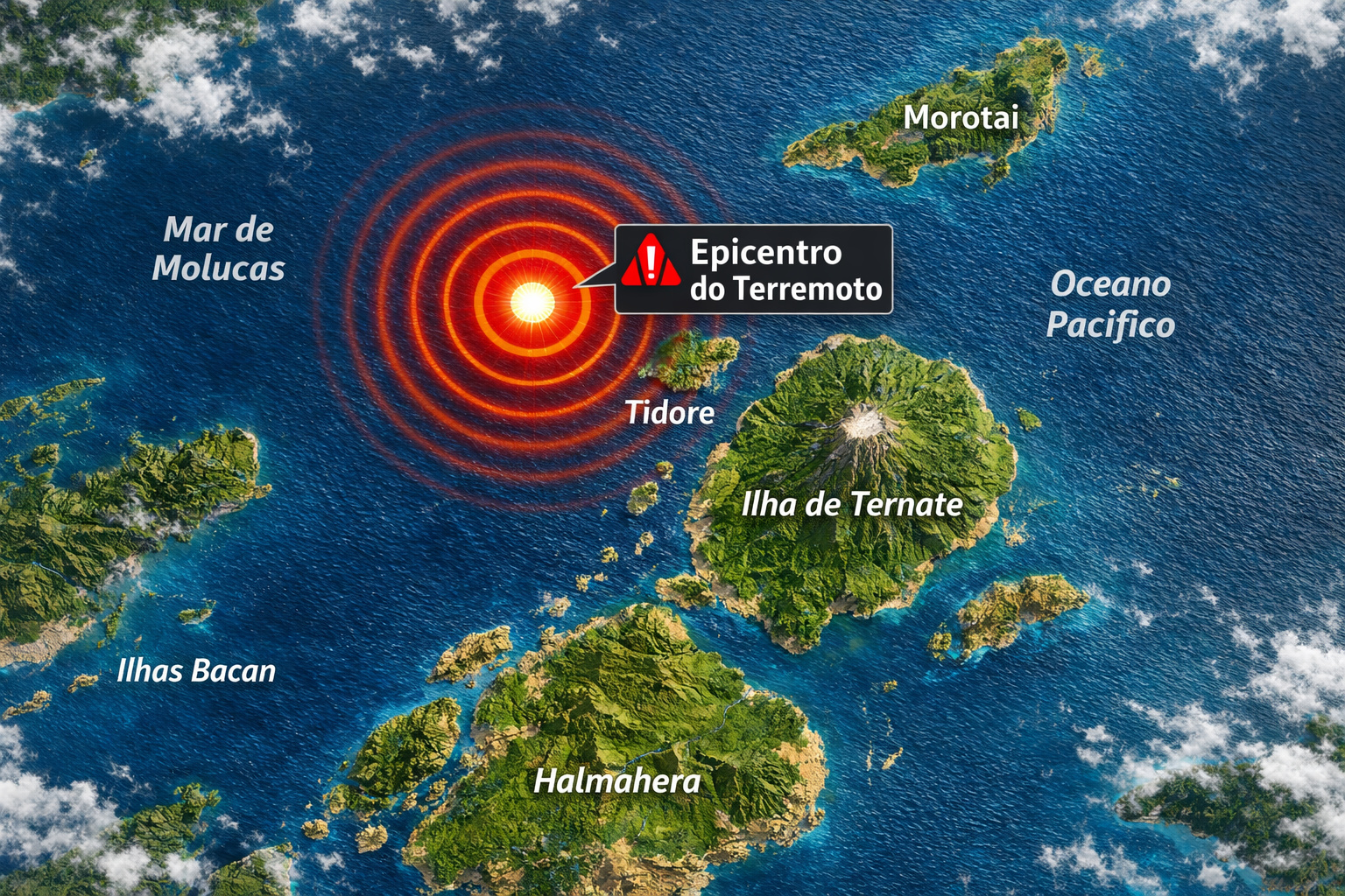
7.8 magnitude earthquake in Indonesia frightens the population, triggers tsunami alert, and hits an island with over 200,000 inhabitants this Thursday.
-
Google will finally let you change that embarrassing Gmail address you created in your teenage years without losing any accounts, logins, or old emails: the feature is already available in the United States.

-
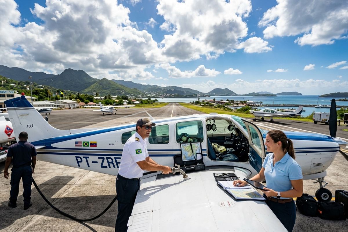
Heading to Brazil in a Bonanza F33 single-engine aircraft: a couple departs from Florida on a visual flight, makes technical stops in the Caribbean to refuel and organize paperwork, and begins the staged crossing until they reach the country.

In total, the highway is 58.5 kilometers long, with dozens of viaducts, bridges, and tunnels that overcome the steep gradient of the Serra do Mar.
Although it was designed to accommodate the intense flow between the plateau and the coast, its layout has also become a visual attraction.

Viewed from above, the mountain stretch looks like a concrete strip suspended over a sea of green, cutting through the Atlantic Forest without blending in with the surrounding vegetation.
This scenery has contributed to images of the highway circulating frequently in reports, engineering channels, and travel profiles on social media, helping to consolidate the perception that it is one of the country’s most impactful roads.
High Viaducts and Gentle Curves in the Mountain Stretch
The mountain stretch of the Imigrantes captures attention for the sequence of high viaducts supported by few pillars, some about 70 to 80 meters high relative to the valley.
This solution allows the roadway to maintain constant slope and long-radius curves, reducing the need for steep ramps or tight curves even in mountainous terrain.
This geometry is particularly important in an area where the combination of altitude, relief, and humidity favors the formation of dense fog at various times of the year.
To address this scenario, the highway’s operation employs restrictive speed limits in the mountain stretch and, in situations of very low visibility, resorts to a safety convoy where vehicles from the concessionaire and the Military Highway Police lead cars at low speeds to reduce the risk of pile-ups.
At the same time, the highway has a monitoring system with cameras, variable message panels, and weather stations distributed along the route, providing real-time information on rain, wind, and visibility.

These tools are used to guide drivers and, when necessary, modify the lane scheme between Imigrantes and Anchieta, prioritizing the direction with higher traffic.
Tunnels, Environmental Conservation, and Sustainable Engineering
In addition to the viaducts, the Imigrantes is notable for the tunnels that cross through the mountain.
In total, there are 14 tunnels distributed along the highway.
On the so-called south lane, built more recently for descent to the coast, three large tunnels and smaller structures add up to over 8 kilometers excavated in rock, in a mountain stretch of about 21 kilometers.
During this expansion, technicians and engineers adopted solutions to reduce environmental impact.
The distance between pillars was increased, decreasing the number of supports within the forest.
The deforested area was significantly smaller than in the original lane.
The water used in excavating the tunnels underwent treatment at stations before returning to natural bodies of water.
This care led the highway to be mentioned as a model of environmental management by technicians from the Inter-American Development Bank, as well as earning the concessionaire the ISO 14001 certification, focused on environmental management.

The combination of elevated viaducts, extensive tunnels, and impact mitigation has established the Imigrantes as a case study in projects that seek to reconcile infrastructure and conservation of sensitive biomes, such as the Atlantic Forest.
Expansion Plans and Future Advancements in the Mountain
The projection of the Imigrantes as a cutting-edge engineering project is also reinforced by ongoing plans for a third lane in the mountain stretch.
The project foresees about 21.5 kilometers of new roadway, comprising approximately 17 kilometers of tunnels and another 4 kilometers of viaducts.
The proposal includes a tunnel estimated to be 6 kilometers long, with the potential to become the largest road tunnel in Brazil.
The new lane was designed to increase the capacity for traffic between the capital and the coast, while also maintaining a focus on safety and reducing environmental impact, replicating the logic that transformed the Nova Imigrantes into a technological showcase.
The forecast includes advanced systems for ventilation, incident detection, and climate monitoring, enhancing control over traffic conditions on days of heavy rain or fog.
Sensation of Travel and the Privileged View of the Atlantic Forest
Those traveling the mountain stretch for the first time often describe the impression of crossing a suspended corridor over the forest.
The car moves along long curves, sometimes entering tunnels, sometimes emerging in open stretches with wide views of the Atlantic Forest and, at some points, the Baixada Santista in the background.
 768w, https://clickpetroleoegas.com.br/wp-content/uploads/2025/12/Imagem-CPG-redimencionada-para-google-discovery-2025-12-10T201244.722-1536×864.jpg 1536w, https://clickpetroleoegas.com.br/wp-content/uploads/2025/12/Imagem-CPG-redimencionada-para-google-discovery-2025-12-10T201244.722.jpg 1920w” sizes=”(max-width: 1290px) 100vw, 1290px” />
Even for regular drivers, the route rarely feels the same.
The variation in light throughout the day, the occasional presence of low fog, or the contrast between the open sky in the plateau and the more humid air during descent cause the same trip to feel different with each passage.
Many choose to descend more slowly, observing the gradual increase in temperature and the change in vegetation as they approach sea level.
This combination of strategic function, complex engineering solutions, and visual integration with the Atlantic Forest explains why the highway has ceased to be merely a connection between two points.
For those crossing the mountain, the route transforms the journey into an important part of the experience, rather than just being an intermediate segment of the trip.


Deveriam colocar o nome do engenheiro negro André Reboucas, responsável pelo projeto
Boa noite seria ótimo se fizesse uma rodovia cortando a Br 369 que liga Manaus a Porto velho por cima respeitando a floresta pois naque trecho a natureza e Exuberante e rica com a pista elevada traria muitos benefícios a natureza e ao homem sem contar a beleza da selva amazônica 🇧🇷🇧🇷
Seria a BR 319. A BR 369 é no Paraná
Em 2025 eu morava no Japão, então assisti uma reportagem na emissora de TV a NHK que na época tinha um programa jornalístico semelhante ao Globo Repórter.
Eles fizeram uma matéria do rodovia dos imigrantes, os repórteres eram içados e pendurados no cabo de aço por um helicóptero.
Eles comentaram que a rodovia dos imigrantes era uma obra de engenharia mais moderna e arrojada do mundo.
Pois o projeto e o trajeto respeitavam a questão ambiental
Os repórteres ficaram deslumbrados com as pilastras em determinado lugar tem a altura de 100 metros aproximadamente
O projeto respeitou muito a natureza
Isso mostra de como a engenharia brasileira é respeitada mundo afora !!!!