 Portuguese
  English
  Spanish
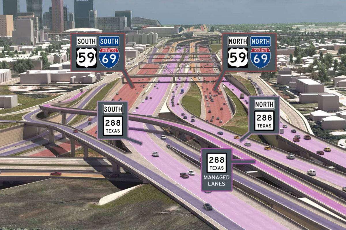
On The Texas Highway I-45, Between Houston And Galveston, 100 Deaths Were Registered In 2023. TxDOT Wants To Reconstruct And Divert Sections, Align I-45, I-69, And I-10, And Widen The Road To Up To 20 Lanes, Alleging Evacuation And Drainage Against Rain And Hurricanes At A Cost Of US$ 13 Billion
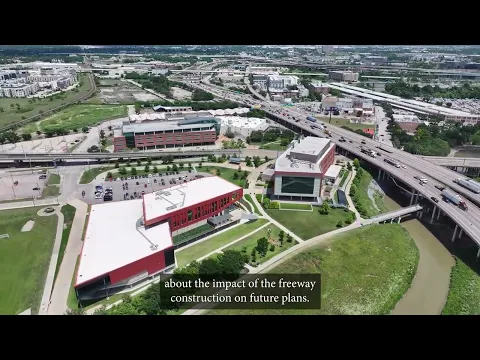
The Texas highway I-45 has become the center of a dispute in Houston: on one side, the justification of safety after more than 100 deaths registered in 2023 and the argument that the road needs to function as an evacuation route during hurricanes; on the other, residents who fear a redesign with permanent impacts on neighborhoods adjacent to the corridor.
The plan, estimated at US$ 13 billion, envisions reconstruction, diversions, and reconfiguration of interchanges, with sections that could reach up to 20 lanes wide, in addition to heavy drainage work in a low-lying city with clay soil, where water often overcomes the asphalt when the rains intensify.
Why I-45 Has Become A Priority Now

I-45 is described as one of the deadliest highways in the United States, and the data driving the project is straightforward: more than 100 deaths in 2023 along the corridor, placing it among the roads with the highest mortality per kilometer in the country.
-
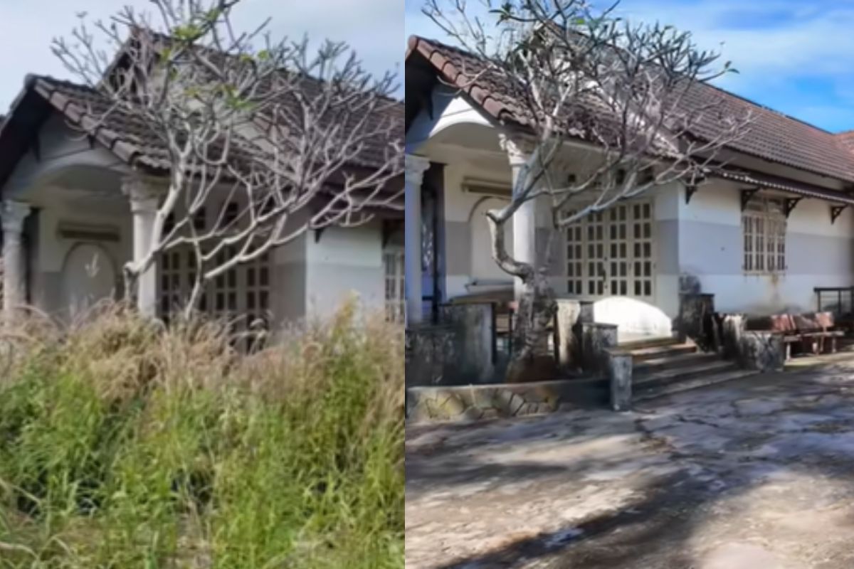
Abandoned house for 15 years disappears in the woods, shocks owner with unrecognizable scenery and is reborn in an intense transformation after almost 90 hours of work in just 10 days.
-
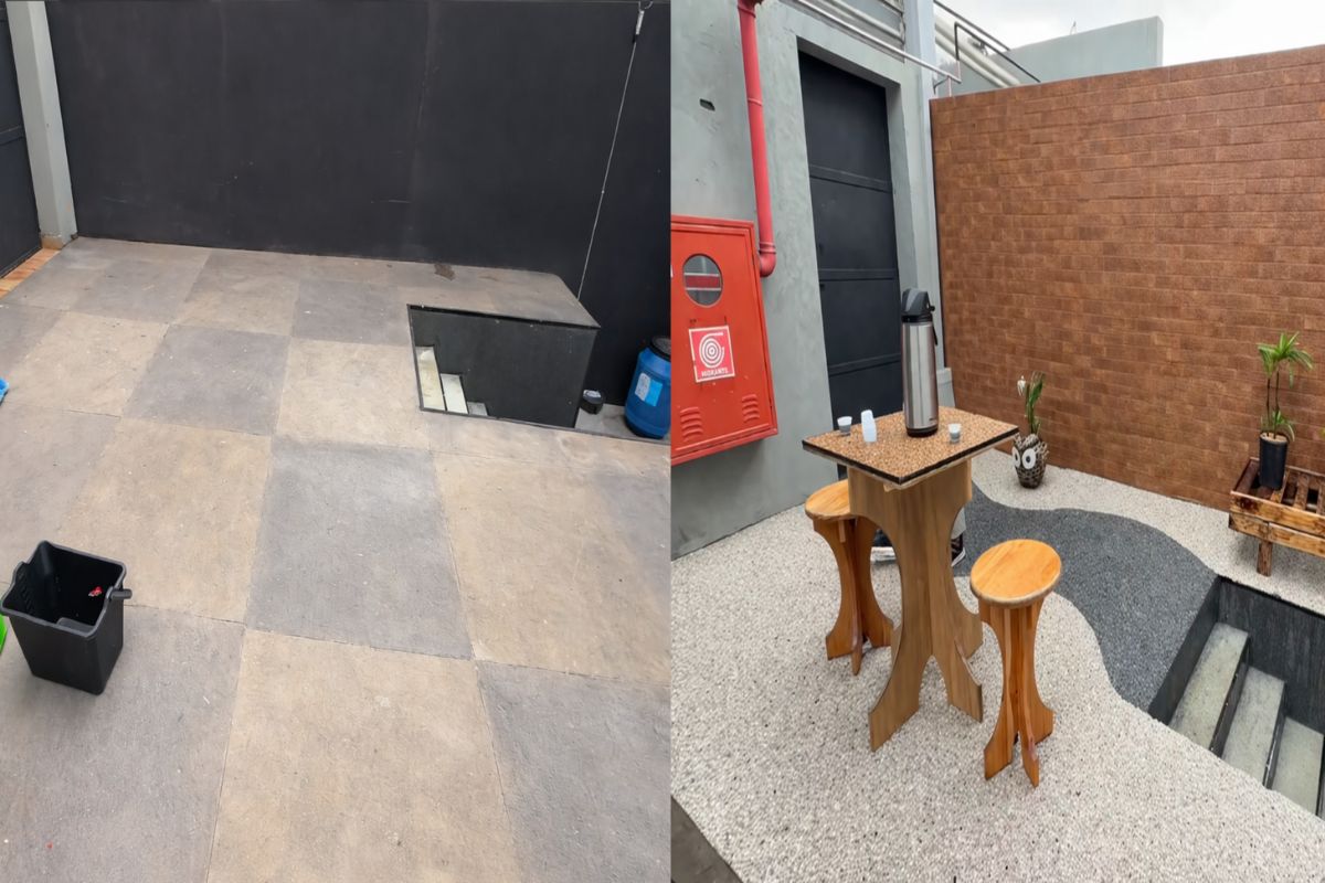
In just three hours, a natural stone floor transforms the entrance of the house with an organic effect, immediate drainage, and a sophisticated non-slip finish that doesn’t puddle water, dries quickly, and impresses with the final result.
-
‘Interlocking brick’ made of earth arrives in the construction industry with cost reductions of up to 40% on the project.

-
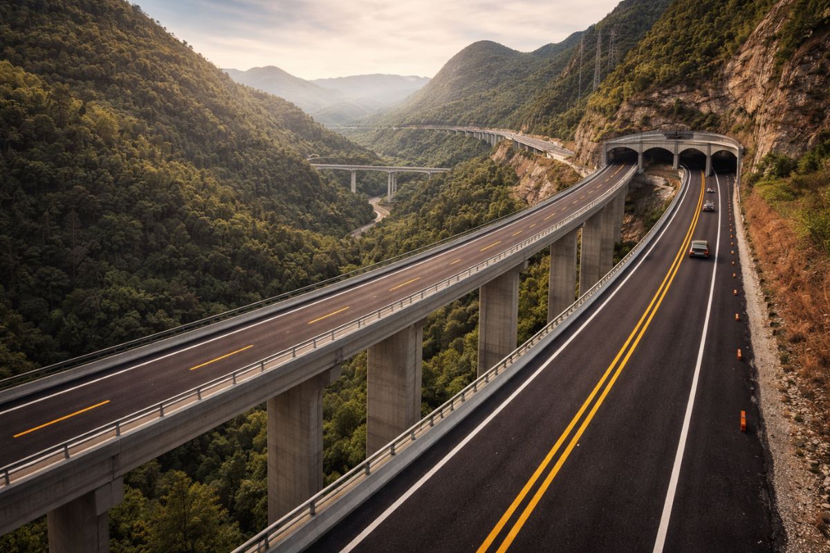
Espírito Santo will receive the largest engineering project in its history with the duplication of BR 262, which will have 50 viaducts, 28 bridges, and 2-kilometer tunnels cutting through the most challenging mountainous region of the entire state.

But the construction package does not rely solely on accident statistics. Houston appears in the diagnosis as a city approximately 40 meters above sea level, with flat topography and soft clay soil.
In addition, urban growth has replaced absorbing surfaces with impermeable materials such as concrete, resulting in a drainage system that cannot handle the volume of water during critical periods.
The climate factor acts as a risk multiplier: the proximity to the Gulf of Mexico supports a humid subtropical climate, with rainy seasons and episodes of heavy rain that cause frequent closures and disruptions on the highway.
Moreover, according to the plan’s own premises, Texas faces hurricanes every few years, which increases the demands on a road that, in addition to handling daily traffic, needs to respond in emergency scenarios.
TxDOT states that sections of the highway do not meet current design standards and, under today’s conditions, do not function as an effective evacuation route during a hurricane.
In this context, the project begins to be presented as a modernization of road safety and resilience.
How Houston Grew Over The Texas Highway

The origin of the corridor helps explain the current conflict. In 1952, the first segment was inaugurated as the Gulf Freeway, connecting Houston to Galveston.
By the 1970s, the complete route of I-45 was opened as a north-south corridor, coinciding with the oil boom that transformed the Texas economy.
With people arriving for new jobs and seeking housing, Houston grew rapidly.
And there is a decisive detail: the city is described as the largest in the U.S. without formal zoning restrictions, which accelerated the multiplication of residential areas along the newly connected I-45 and in more distant zones.
Decades later, the bill comes in the form of congestion and demand pressure, with suburban workers, residents, and visitors mixing daily in an intense flow.
TxDOT projects a 40% increase in traffic on the North Corridor of I-45 by 2040, reinforcing the capacity argument.
At the same time, the material records a symbolic shift: when the Gulf Freeway was built, it replaced an existing electric train line between Galveston and Houston, a point that fuels current criticisms about the priority given to cars over public transportation.
What Changes In The Layout And Why The Talk About Up To 20 Lanes
The US$ 13 billion package is described as a large-scale reconstruction and reorganization, divided into three segments, each with multiple phases.
The overall logic combines capacity, safety, and drainage.
In Segment 3, work has already begun, and the focus is on reconstructing the expressway system downtown, aligning highways, and improving stormwater drainage.
A portrait of the construction site appears on St. Emanuel Street, east of downtown, with excavations alongside the pavement to install water and sewage pipes, followed by the opening of a larger hole to install concrete boxes, cited as drainage systems, which will channel water during heavy rains to a detention reservoir under construction.
It is a visible part but described as only the tip of the iceberg.
The central redesign envisions a major diversion: I-45 would be shifted from the city center, from west to east, to align with I-69 and I-10, promising to optimize flow, reduce congestion, and provide a safer evacuation route.
In this design, original sections of I-45 west of downtown would be removed and an expressway built in its place.
This adjustment creates a domino effect. The I-10, which connects east and west, would be reconstructed in sections to better align with the new layout. Two high-impact nodes also come into play: an interchange with I-10 and another for the intersection of I-45, I-10, and I-69.
It is within this set that the width estimate arises: the reconstructed highways could have up to 20 lanes to accommodate the projected volume of cars for the coming years.
In Segment 2, the work would connect the improvements of Segment 3 to the I-610 ring, expanding the link to the north and center.
The proposal includes adding lanes and considering lowering the main roadway below ground level.
In drainage, measures such as excavating more retention basins and replacing existing storm drains with bridges appear, with the aim of improving runoff and reducing flooding on the roadway.
The Segment 1 connects Segment 2 to the Beltway 8, a toll road of 142 kilometers that circles Houston.
The package includes widening the highway with more lanes and connections, building a new overpass on Blue Bell Road, adding even more retention basins, and widening bridges over Halls Bayou.
Why The Residents’ Reaction Is So Strong
The expansion does not happen in an urban vacuum. The Texas highway I-45 is surrounded by residential neighborhoods on both sides, and the material describes the fear that the social cost could be enormous.
Organized criticism appears with name and phrase: Stephany Valdez, from the group Stop TXDOT I-45, claims that the state should invest in transportation and not highways, quoting an internal joke that it would be a “Department of Highways” and not a “Department of Transportation.”
The mobilization gained a slogan: “We want trains, not more lanes”, echoed in protests.
And there is a contextual data that fuels frustration: a planning budget of US$ 64 million for a high-speed train line between Dallas and Houston was canceled by the federal government, labeled as a waste of taxpayers’ money.
At the core of the controversy are direct impacts. Experts point out that hundreds of businesses, thousands of houses, schools, worship places, and parks may disappear, altering neighborhoods forever.
Valdez also argues that there is a historical pattern: highways as a method of racial segregation, with evidence of governmental intent to direct major roads through low-income neighborhoods and minorities.
In her view, when demographic and construction maps intersect, the current program would repeat the same logic, compounded by information barriers for parts of the population, including residents who speak Spanish and might not be clear about what is happening and the risk of losing their homes.
TxDOT, in turn, vehemently denies allegations of racism or directing construction with that goal.
The Official Defense Of TxDOT And What They Promise In Counterparts
The institutional response relies on Houston’s growth and the significance of the corridor. The metropolitan area is described as having seven million inhabitants and a projected population growth of over 80% by 2050.
Experts also assert that the I-45 corridor houses nine of the 25 most congested highways in Texas.
Under the umbrella called the North Houston Highway Improvement Project (NHHIP), TxDOT claims that the region will receive more than US$ 43 billion in benefits, including economic development, reduced travel time, and environmental benefits, as well as safety and mobility gains.
The agency states that the project has been in development for over a decade, with community participation and regional support.
To mitigate impacts, TxDOT claims to have documented a commitment of US$ 30 million in direct financial assistance to affected neighborhoods to support affordable housing initiatives, citing the construction of single-family or multi-family homes and support for assistance and outreach programs.
The implementation would be managed by a grant program, the NHHIP Affordable Housing Revitalization Program, with negotiations with the Texas State Affordable Housing Corporation to manage the funds.
Additionally, the department emphasizes that there is mandatory assistance for acquisition and relocation for residents and businesses affected by right-of-way, and maintains transparency through public engagement.
The volume of consultation cited is high: more than 300 meetings with the public, including local residents, stakeholders, and businesspeople, with the argument that suggestions were incorporated into the plan.
Timeline, Phases, And What Comes Next
Work on Segment 3 continues while public consultation proceeds in parallel. Experts indicate that once financing is approved, the start of Segment 2 is scheduled for 2028, followed by Segment 1 in 2032.
In practice, it is a long-term project that spans governments and economic cycles and keeps the conflict alive for years.
The case summarizes a classic infrastructure dispute: capacity and resilience on one side, social cost and urban design on the other.
In Houston, the Texas highway I-45 has become the stage where these priorities collide, with billions at stake and entire neighborhoods looking at the map to try to understand what will be left when the dust settles.
Do you think widening the Texas highway to up to 20 lanes resolves the problem in Houston, or just postpones the crisis and increases the impact on neighborhoods?


-

Uma pessoa reagiu a isso.