 Portuguese
  English
  Spanish
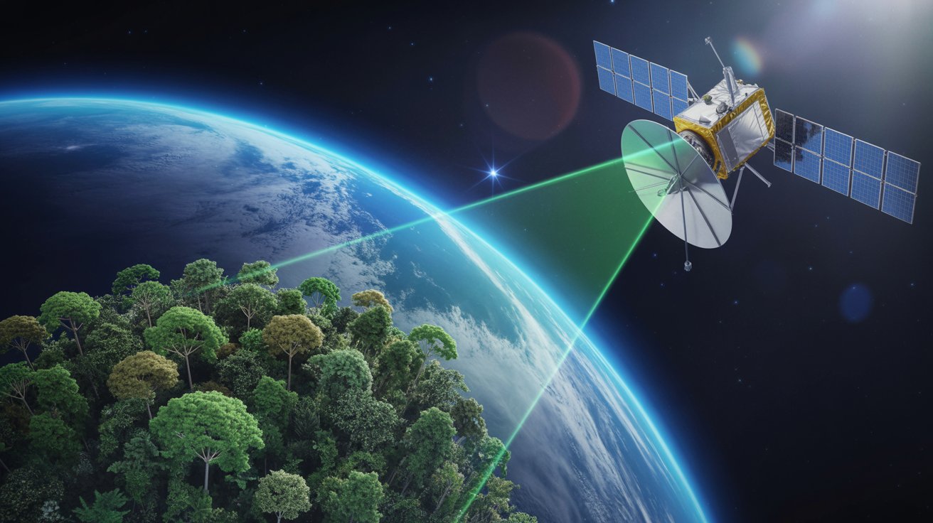


Launched Less Than Two Months Ago, The ESA Biomass Satellite Impresses With First Images Captured By The New P-Band Radar In Space, Capable Of Penetrating Dry Soil, Ice, And Forest Layers To Measure Carbon Stored In The Planet’s Trees
The Biomass satellite, recently launched by the European Space Agency (ESA), has released its first radar images revealing underground structures in the Sahara, glaciers in Antarctica, and the Amazon rainforest. The mission’s primary objective is to accurately measure the volume of carbon stored in the trunks and branches of forests worldwide.
With unprecedented technology, the satellite is the first to operate in space with a synthetic aperture radar in the P-band range, capable of penetrating dense tree canopies, dry sand layers, and ice. The mission’s initial phase, called commissioning, is adjusting the systems to ensure accurate data collection over the next five years.
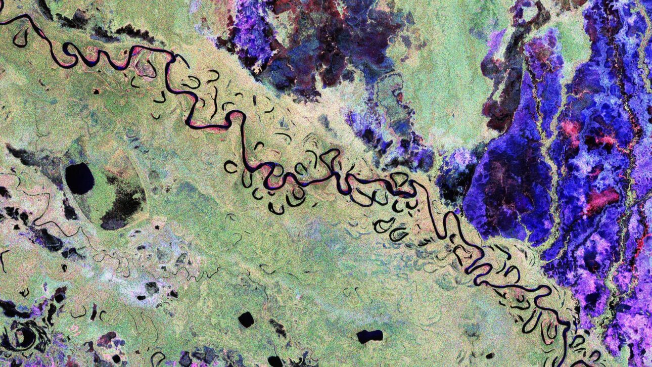
Even in this preliminary phase, the first images released during the Living Planet Symposium have already caught attention for their clarity and depth. One of the scenes shows the Rüthen region in Bolivia, where deforestation for agricultural expansion can be clearly mapped, assisting in the calculation of carbon release.
-
China has launched the world’s first floating artificial island, a scientific structure designed to face open seas, test equipment weighing hundreds of tons, and reach depths of 10,000 meters.
-
China accelerates global science and may surpass the United States in 2 years with increased public investment, continuous growth, and direct impact on the global technological competition.

-
Scientific studies indicate that drought may be strengthening a much greater silent threat: more resistant superbugs.
-
Man builds functional 5-meter submarine in his garage using gas cylinders, PVC pipes, and a refrigerator motor, and navigates with the vessel on a lake in Colombia.

Radar Reveals Landscapes Beneath The Ice And Desert
Among the highlights released, are detailed images of the Tibesti Mountains in Chad, where the radar penetrated up to five meters of dry sand to reveal buried riverbeds and volcanic structures. This information can assist in water management planning for arid regions.
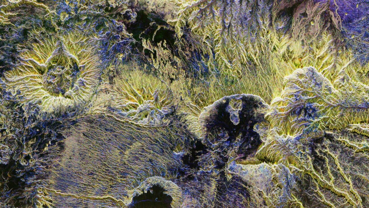
Another image shows the snow-covered Transantarctic Alps, highlighting the slow movement of the Nimrod Glacier towards the Ross Ice Shelf. This radar penetration capability is essential for understanding glacier dynamics and impacts on sea level.
The continuous collection of these images will allow for the creation of three-dimensional global maps of forest biomass, with annual updates. This represents a significant advancement for monitoring each country’s climate goals.
Amazon, Indonesia, And Biodiversity In Focus
In the Brazilian Amazon rainforest, the satellite identified areas that are seasonally flooded through variations in radar tones, distinguishing vegetation from flooded areas. In the Indonesian archipelago, the equipment revealed details of the volcanic terrain beneath the dense vegetation, including the active Gamkonora mountain.
Unlike optical sensors, such as those used in the Sentinel-2 mission, Biomass captures data from the canopy to the ground, providing a three-dimensional view of the ecosystem. This will allow for unprecedented accuracy in estimating tree height, wood volume, and variations in carbon storage.
With this approach, the ESA aims to provide the international scientific community with crucial data to refine carbon cycle models, monitor conservation policies, and assess the impact of land-use changes.
Expected Timeline For Data Release
Over the coming months, engineers will continue to calibrate the radar signals, adjusting orbital positions and measuring the signal-to-noise ratio. The mission is expected to reach full operation later this year, with open access to data for researchers worldwide.
According to Michael Fehringer, project manager for Biomass at ESA, the initial results are promising. “The images are just a glimpse of what is to come. We believe the satellite will fulfill its role in providing an accurate inventory of global carbon stocks in forests,” he stated.
The information was released by EarthSnap and the European Space Agency during the Living Planet Symposium, in recent publications highlighting the scientific and climate relevance of the Biomass mission.


Eles querem nos espionar .
É assim que descobrem as riquezas dos países. Ouro, petróleo, nióbio, grafeno, cobre…
Daí é só mandar umas ONGs para impedir a colonização e o desenvolvimento da região de interesse, em geral sob pretextos ecológicos, mantendo-se assim uma reserva de riquezas **** que será TOMADA quando for necessário.
Qualquer semelhança com a Amazônia NÃO é mera coincidência!
Quanto às nossas Forças Armadas, o Enéias estava certo: sem a bomba o Brasil é presa fácil para pelo menos uma dúzia de países.