 Portuguese
  English
  Spanish
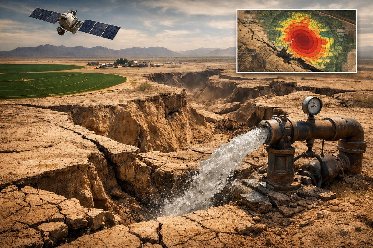
With Arizona Sinking More Than 15 Cm Per Year, Satellite Images Detect Accelerated Subsidence in the Willcox Basin, Linked to Pumping for Agriculture. Since the 1950s, Some Areas Have Sunk Up to 3.6 M; Between 2017 and 2021, Sections Lost Nearly 1 M and Opened Widespread Cracks, Leading to Irreversible Loss.
In southern Arizona, the expression Arizona Sinking has ceased to be a metaphor and has become a measure: satellites have captured areas sinking more than 15 centimeters per year, a rate that reveals a subterranean transformation difficult to see with the naked eye, but easy to feel when wells fail and the ground cracks.
The picture is clear in the Willcox Basin, where decades of intensive groundwater extraction to sustain agriculture have lowered the water table and pulled the surface down; even when the rain returns, the ground may continue to sink, because part of what is lost underground does not replenish.
What Satellites Have Been Able to Measure and Why This Changes the Game

What makes the case of Arizona Sinking so clear is the type of measurement: a satellite radar technique called InSAR (Interferometric Synthetic Aperture Radar). Instead of relying on isolated points on the ground, InSAR compares the distance between the satellite and the surface in sequences of passes, allowing it to detect small variations in elevation over time and map where subsidence is occurring most rapidly.
-
NASA issues a warning for the feared Godzilla El Niño that could change the planet’s climate in 2026 with extreme warming of the Pacific capable of causing devastating droughts in some regions and historic floods in others simultaneously.

-
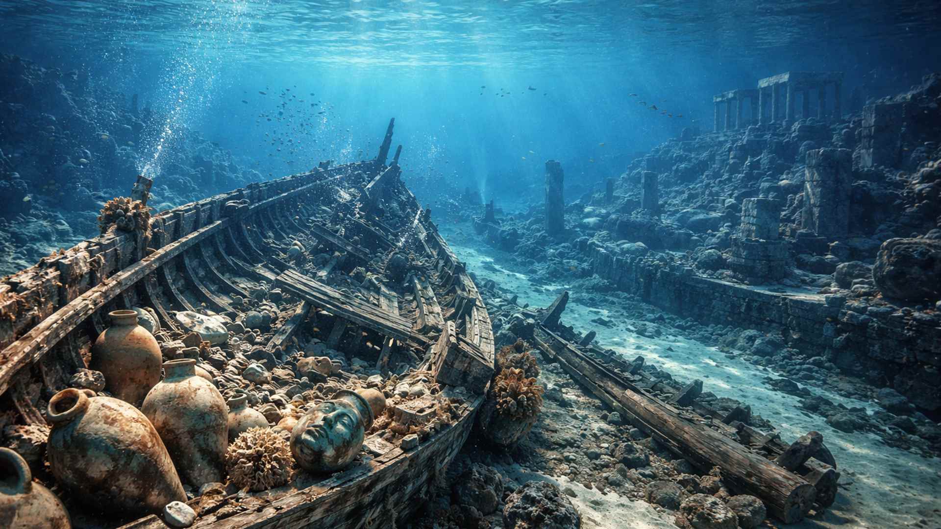
Archaeologists discover a 100-meter ship graveyard in a submerged Greek city, and what has appeared on the seabed of Libya could change what was known about this ancient port.
-
You buy the refrigerator and still have to see ads: Samsung starts displaying advertising on appliances and generates negative reactions among consumers.

-
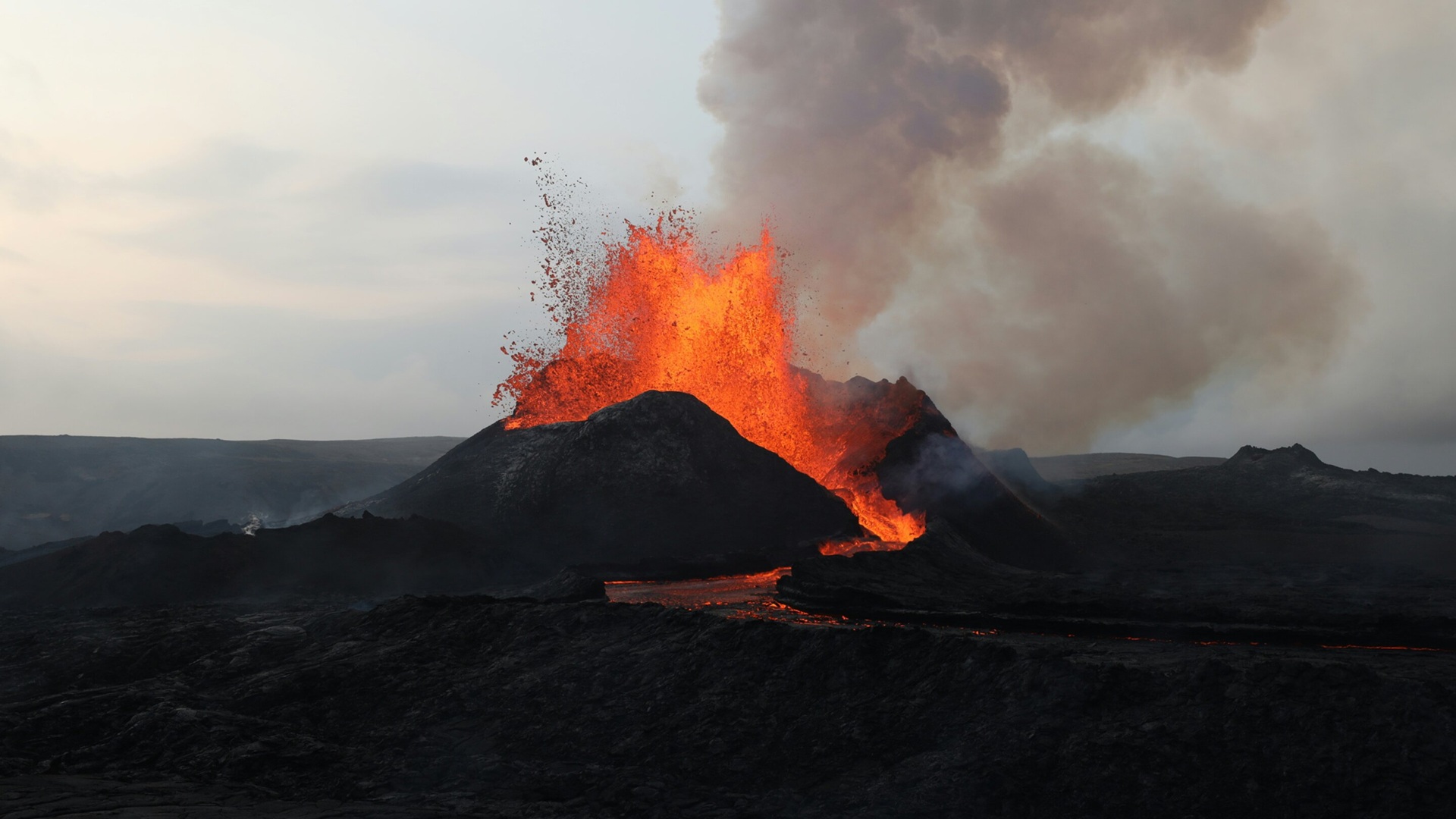
What can really trigger large volcanic eruptions? Research suggests that gas returning to the magma may be more dangerous than gas escaping from it.
When applying this technique in the Willcox Basin between 2017 and 2021, the analysis showed that some areas sank nearly 1 meter during that time, with mentions of sections that reached 90 centimeters in just four years.
When this translates into an annual rate, areas above 15 centimeters per year emerge, described as the fastest subsidence in the state, helping to identify the points of greatest pressure and anticipate where impacts are likely to concentrate.
Why Removing Water from the Subsurface Causes the Ground to Sink Permanently
The logic behind Arizona Sinking lies in the structure of the aquifer: groundwater occupies spaces between dust and dirt particles beneath the surface. These voids act as an “invisible reservoir,” keeping the sediment structure more “open” due to water pressure.
When water is removed in large volumes over extended periods, the porous spaces begin to collapse because the sediment cannot support its own weight.
This collapse is crucial because it’s not just “less water”: it’s less space to store water in the future. Once compacted, the sediment loses storage capacity, and the basin struggles to recover what it once held.
That’s why, at the heart of Arizona Sinking, there lies an uncomfortable idea: part of the aquifer ceases to be a reservoir and becomes a compacted volume, a space that “once was” and will not return to what it was.
Where This Is Happening and How Much Has Already Sunk Since the Mid-20th Century
The main scenario of Arizona Sinking described here is the Willcox Basin. Previous research has indicated that since the 1950s, parts of this basin have sunk up to 3.6 meters.
This number gives a historical dimension: it is not a short event, but rather a deformation accumulated over decades, associated with groundwater extraction.
The most recent data, however, changes the perception of urgency: between 2017 and 2021, areas are reported to be sinking almost 1 meter, with some above 15 centimeters per year.
When land “sinks” at this rate, it’s not just a scientific record; it’s a signal that subterranean compaction is active, and that the pressure on available water (and on the soil itself) remains high.
Cracks, Wells Drying Up and the Cascading Effect on Life Outside the Graphs
The most direct consequence of Arizona Sinking is physical: wells may dry up when the water table drops and when subterranean dynamics change.
For a region that relies on groundwater for agriculture, this means operational risk, rising costs to maintain extraction, and in extreme cases, loss of viability of productive areas.
At the same time, the ground responds with cracks and fissures. They emerge because subsidence does not occur perfectly uniformly: some sections sink faster than others, creating tensions on the surface.
The ground “opens” because the subsoil is reorganizing, and this type of fissure is not merely aesthetic; it can affect local infrastructure, rural roads, networks, and any structure supported by ground that is changing level.
Why Even Heavy Rains Couldn’t “Turn Off” the Sinking
One point that stands out in the case of Arizona Sinking is that even heavy rains in 2022 and early 2023 were not enough to stop the continuation of subsidence.
There was a temporary rise in underground water levels, but the ground continued to sink, and in some areas, the process even accelerated.
This suggests a practical limit to “letting it recharge”: when compaction has already advanced, natural recharge may not compensate for the withdrawal—not due to a temporary lack of water, but because the aquifer loses part of its physical storage space.
It’s like trying to fill a container that has been crushed from within: even if water arrives, its capacity is no longer the same.
What Management Can Do and Why the AMA Is Central to the Story
In the face of Arizona Sinking, the debate about regulation arises. In 2024, authorities declared the Willcox Basin an Active Management Area (AMA), a tool that could limit extraction and attempt to preserve what remains of the capacity to store groundwater.
The details of the plan are still being finalized, but the logic is to reduce the ongoing pressure that fuels subsidence.
There is also an important contrast within the state itself: in regions like Phoenix and Tucson, groundwater management is associated with recovery of levels and significant reduction in subsidence rates, with reports that subsidence is no longer observed in Tucson due to management.
At the same time, the long-term view remains cautious: even with an AMA, the expectation is not to “zero out” the problem, but to slow it down because part of the process, once it has become compaction, tends to be persistent.
What Is at Stake When the “Invisible Reservoir” Becomes Collapsed Space
The core of Arizona Sinking is a collective decision about time and limits: the more that is removed now, the greater the chance of converting an aquifer that could buffer future droughts into a system with less storage capacity.
And when this internal “crushing” happens, the cost is not just in water, but in the stability of the territory.
In the end, the question is not just “how much has sunk,” but rather how much of the subterranean capacity can still be preserved before subsidence becomes the new normal.
The Willcox Basin exposes a type of loss that occurs below the line of sight and that, when manifested as cracks and dry wells, is already in an advanced phase.
And you: in your city or region, have you seen signs of ground cracking, wells fluctuating, or restrictions on water use?
Do you think mandatory extraction limits should come before the crisis or only after the impact appears?


-

Uma pessoa reagiu a isso.