 Portuguese
  English
  Spanish
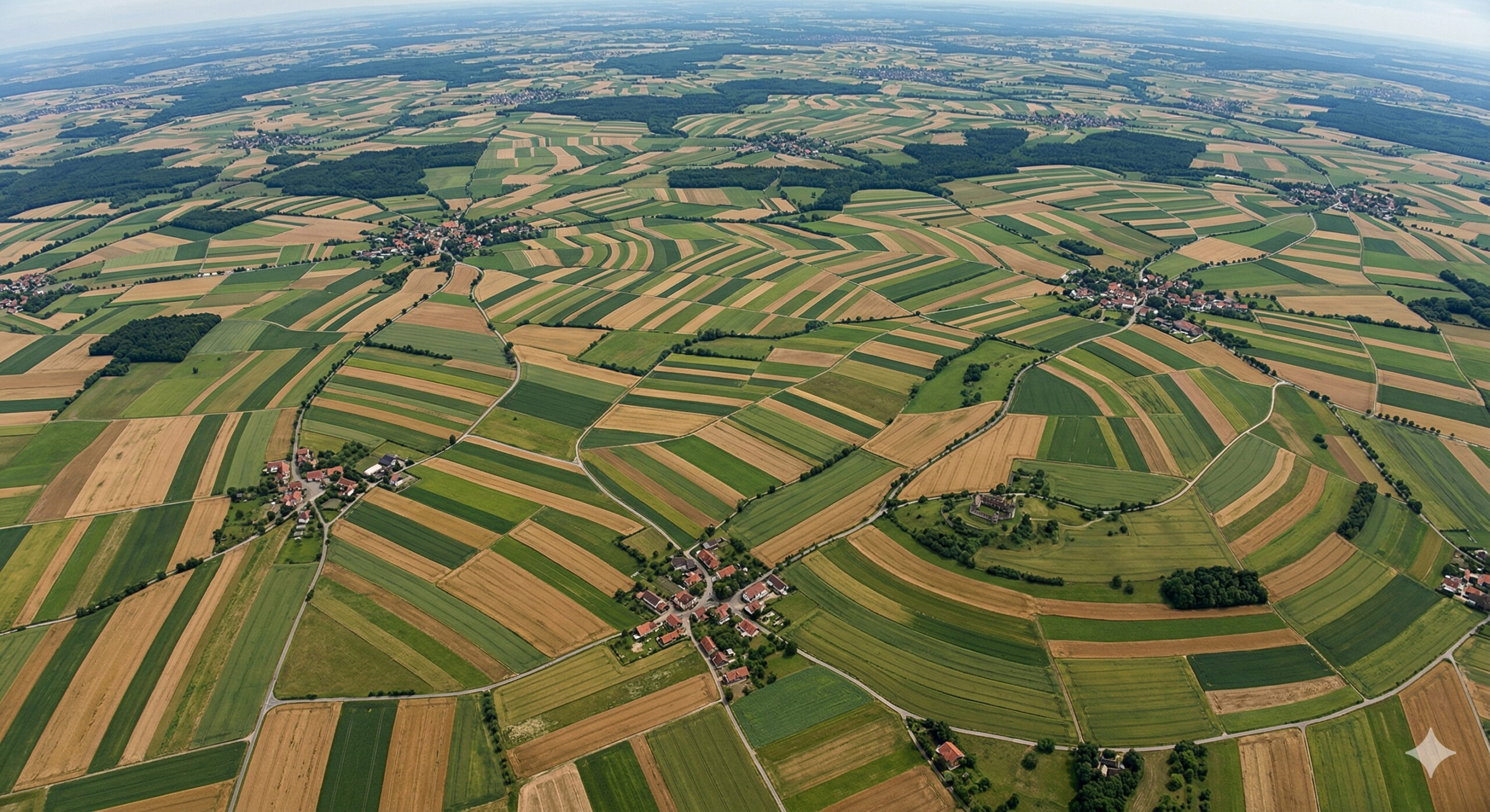
Satellite images show irregular fields in Germany and reveal medieval heritage that still defines land use after more than 700 years.
In analyses based on NASA orbital images obtained by the ASTER sensor aboard the Terra satellite, experts identified a pattern that completely deviates from what is expected in modern agricultural areas. In the northwest of Germany, large expanses of rural territory appear as a mosaic of small, irregular fields without geometric repetition, forming a design that, seen from space, looks chaotic. This type of landscape directly contrasts with agricultural regions like those in the United States, where fields typically follow rectangular blocks and regular alignments, giving rise to the irregular agricultural fields in Germany.
According to an official publication from the NASA Earth Observatory, while in Minnesota the regular design of fields reflects land surveys from the 19th century and adaptation to the use of machinery, in the northwest of Germany the small size and random pattern of the plots are remnants of the Middle Ages. This visual difference, therefore, is not the result of chance or a lack of contemporary planning, but rather the outcome of a land organization shaped by much older historical processes.
The interpretation of these images reveals that the current landscape is not contemporary in its essence, but a direct reflection of how the land has been organized over centuries. What is now captured by satellites does not only show active agriculture but also a territorial record preserved over time, where the visible structure of the soil still carries marks of medieval European occupation.
-
The most economical refrigerator in Brazil consumes only 26.5 kWh/month and costs around R$ 20.67, outperforming rivals by up to 200% in consumption; see the ranking with real data, inverter technologies, and annual savings exceeding R$ 2,500.

-
More than 50 cell phones are already compatible with Starlink without an antenna, which promises to eliminate signal dead zones on the planet, but Brazilians still need to wait for the operators to finalize agreements for the service to work here.

-
An extratropical cyclone with winds exceeding 100 kilometers per hour and a risk of hail is forming between Rio Grande do Sul and Santa Catarina this week, and a cold front will advance over the entire Southeast shortly thereafter.

-
Brazil has a laboratory with more lethal viruses and operates with restricted access and strict protocols.

Medieval feudal system shaped land division and explains the irregular shapes of the mosaic of irregular agricultural fields in Germany
To understand why German agricultural fields have this pattern, it is necessary to go back to the medieval period, when the territorial organization of Europe was based on the feudal system. In this model, land was controlled by local lords who divided it among peasants according to criteria that varied by region.
Unlike modern models, there was no standardized logic of division. Lands were fragmented according to immediate needs, social relations, and local agreements. Each plot was defined independently, without concern for symmetry or geometric continuity, resulting in a set of agricultural areas with distinct and often irregular shapes.
This system, known as the open-field system, allowed the same farmer to access different plots scattered across the territory, often with varying soil characteristics. Over generations, these divisions were inherited, subdivided, and adapted, but rarely reorganized on a large scale. The accumulated effect of these individual decisions created a territorial pattern that, even centuries later, remains visible.
Most importantly, these divisions did not disappear with the advance of modernity. On the contrary, they were incorporated into the land structure that supports current agriculture, demonstrating an unusual historical continuity in terms of land use.
Persistence of more than 700 years shows how local decisions shaped the modern landscape and created a mosaic of agricultural fields
One of the most impressive aspects of this phenomenon is its durability. Even after the introduction of advanced agricultural technologies, intensive mechanization, and profound economic changes, the basic structure of the fields has remained virtually intact in many regions.
This permanence is linked to structural factors that hinder radical changes in the organization of territory. Consolidated property rights over generations, high costs of land reconfiguration, and adaptation of existing infrastructure to old boundaries are elements that contribute to the preservation of the original pattern.

Moreover, many of these areas have historical and cultural value, which reinforces the tendency to maintain the traditional configuration. This means that when observing the current agricultural fields, one is not only seeing a productive landscape but also a continuous historical record.
This characteristic makes Germany an emblematic case of how decisions made more than 700 years ago still directly influence contemporary spatial organization, something rare in a world marked by constant territorial transformations.
Comparison with the United States reveals difference between modern planning and historical heritage
The comparative analysis between Germany and the United States further highlights this contrast. In the United States, land occupation was organized primarily from the 19th century, based on surveying systems that divided the land into regular and standardized blocks.
This model created a landscape characterized by straight lines, defined angles, and geometric repetition, facilitating mechanization and land management. In Germany, on the other hand, the landscape reflects a completely different process. There was no systematic redesign of the territory, but rather the continuity of a structure built gradually over centuries.
This difference is not only aesthetic but also historical and functional. While the American model represents a planned and centralized approach, the German pattern represents an organic system, the result of decentralized decisions accumulated over time.
The impact of this difference can be directly observed in satellite images, where the contrast between the two models becomes evident even without in-depth technical knowledge.
Agricultural geography studies confirm direct link between medieval past and current land use
Research in agricultural geography has shown that there is a direct correspondence between medieval divisions and current land use in various regions of Germany. By cross-referencing historical maps with modern data obtained from satellites, experts have identified that many current boundaries follow exactly the same lines established centuries ago.
This continuity indicates that the land structure not only survived over time but also was integrated into modern economic development, adapting to new conditions without losing its original characteristics. Villages and towns continue to be located at historically defined strategic points, while the fields maintain shapes that reflect ancient decisions.
This type of persistence is one of the factors that make the German agricultural landscape a relevant object of study in various fields, including geography, history, and economics.
Theoretical model of Johann Heinrich von Thünen helps understand agricultural space organization
In the 19th century, the German economist Johann Heinrich von Thünen developed a model that sought to explain how land is used based on distance and transportation costs. Although his model is idealized and represented by concentric circles, it was inspired by real observations of the European territory.

The German agricultural landscape, with its irregular distribution and diversity of uses, contributed to the formulation of these theories. Von Thünen’s work helped establish a scientific basis for understanding how economic and spatial factors influence land use, and continues to be a reference in contemporary studies.
Even though the model does not directly represent the irregularity observed in satellite images, it reinforces the idea that the organization of territory is deeply linked to historical and economic processes.
Orbital images transform irregular agricultural fields in Germany into a visual record of European history
The advancement of Earth observation technologies has allowed patterns like this to be analyzed on a global scale. Images captured by satellites not only show the current distribution of fields but also allow for the identification of patterns that reflect long-term historical processes.
In the case of Germany, these images reveal that the rural landscape functions as a visual document that records centuries of human occupation, preserving traces that would be difficult to perceive from local observations.
This historical reading capability from space enhances the value of these images, which cease to be merely technical tools and become instruments of historical interpretation.
Modern agriculture operates on a medieval territorial structure still preserved
Despite all the modernization of the agricultural sector, including advanced mechanization and the use of digital technologies, the territorial base on which this production occurs continues to be, in many cases, the same defined during the Middle Ages.
This means that modern machines operate in fields whose boundaries were established centuries ago, and that contemporary decisions still need to consider a structure inherited from the past. This coexistence between modern technology and medieval land organization is one of the most striking aspects of the German agricultural landscape.
This characteristic demonstrates that technological evolution does not necessarily eliminate old structures but often adapts to them, creating a scenario where different historical periods coexist in the same space.
What seems disorganization seen from space is, in fact, a coherent historical pattern
When observing satellite images without context, it is easy to interpret the irregular pattern as disorganization. However, understanding its origin makes it clear that it is a highly coherent structure from a historical perspective.
Each field represents a specific decision, and the sum of these decisions forms a system that, although it does not follow geometric patterns, has its own logic. The apparent chaos is, in fact, the result of centuries of decentralized organization, where multiple agents gradually shaped the territory.
This interpretation completely changes how the landscape is viewed, transforming it from a simple set of agricultural areas into a complex historical record.
Have you noticed that the landscape seen from space can reveal decisions made more than 700 years ago?
The analysis of the German agricultural landscape shows how land use can carry deep historical information, often invisible in everyday life. When observed from space, this landscape reveals a narrative that directly connects the past and the present.
In light of this, a relevant question arises: how many other regions of the world still preserve, in their territorial organization, decisions made centuries ago that continue to influence how we live today? Share your thoughts in the comments.


Seja o primeiro a reagir!