 Portuguese
  English
  Spanish
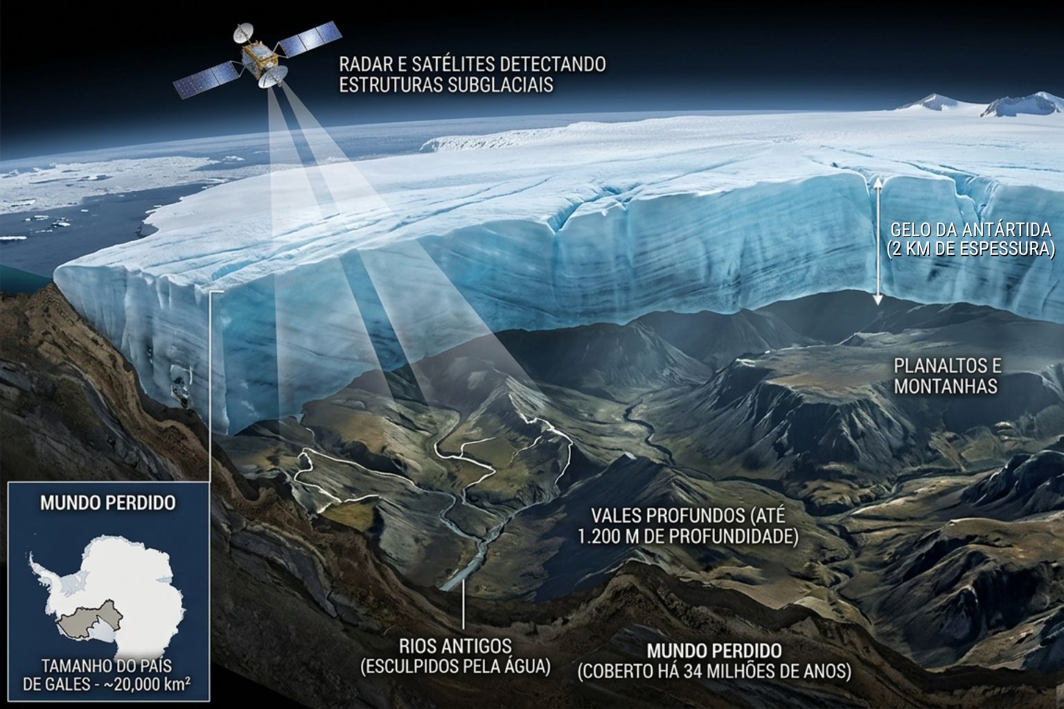
Under the Antarctic ice, scientists identify a fossilized landscape with rivers and deep mountains that reveal what the continent was like before freezing and transforming into the current extreme environment.
East Antarctica hides beneath nearly two kilometers of ice an intact landscape that has not seen sunlight for over 34 million years. The discovery was made by a team led by glaciologist Stewart Jamieson from Durham University in England, using the Canadian RADARSAT satellite system and airborne ice-penetrating radar surveys.
According to the study published in Nature Communications, the mapped area covers approximately 31,000 square kilometers — equivalent to Wales or the state of Maryland — and contains three large blocks of high land measuring 120 to 170 kilometers in length, separated by valleys up to 40 kilometers wide and nearly 1,200 meters deep. “It’s like opening a time capsule,” said Jamieson.
The continent that was once green
34 million years ago, Antarctica was not the frozen desert we know. It was part of Gondwana — the supercontinent that included South America, Africa, India, and Australia. The climate was temperate. Rivers flowed through coastal plains, dense forests covered the land, and biodiversity was comparable to that of modern Patagonia.
-
A 2 kg exoskeleton with an 800-watt motor and artificial intelligence that predicts movements in 2 milliseconds reduces the load on the legs by up to 30 kg, increases strength by 40%, and allowed an 84-year-old woman to climb mountains without falling behind.

-
The Senna Tower in Balneário Camboriú is using stakes considered unique in the world that go down 40 meters and are driven 5 meters into the hardest rock on the planet, with technology approved by the same engineer who designed the Burj Khalifa.

-
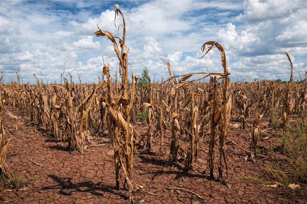
The drought may be pushing a much larger crisis than just a lack of water; in addition to affecting crops, reservoirs, and cities, it can also help strengthen bacteria that no longer respond well to antibiotics.
-
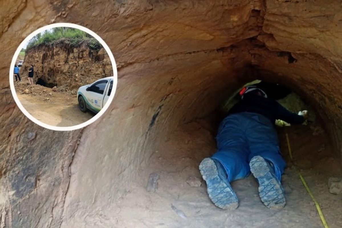
A resident of Santa Catarina found a tunnel over 10,000 years old dug by animals the size of a car on her own property, and the video of the discovery has already surpassed 3 million views on social media.

Pollen from palm trees and microfossils of aquatic organisms were found in sediments extracted near the study area, confirming that the environment was humid, warm, and biologically active. The landscape revealed by satellites now beneath the ice was sculpted by these rivers — not by glaciers. The channels, valleys, and ridges identified by researchers have patterns of fluvial erosion, not glacial.
How to find rivers beneath two kilometers of ice
The researchers did not drill into the ice. They used a combination of two remote sensing technologies that together allowed them to map the buried terrain without touching it. The first was the RADARSAT satellite, which detects minimal variations in the tilt of the ice surface. These imperceptible undulations reflect the shape of the terrain below — like a sheet stretched over furniture reveals its contours.
The second was radio-echo sounding (RES), conducted by aircraft flying over the area emitting radar pulses downward. The signal passes through the ice, hits the rock, and returns. The return time reveals the depth and shape of the bedrock. By combining the two data sets, the researchers constructed a three-dimensional map of a world that no one has seen in 34 million years.
Three blocks of high land separated by abysses
The map revealed an organized geological structure: three large blocks of elevated terrain, each measuring between 120 and 170 kilometers in length, separated by deep valleys up to 40 kilometers wide.
The valleys reach nearly 1,200 meters deep — comparable to the Grand Canyon in vertical scale. When researchers applied isostatic compensation models to correct for the weight of the ice on the terrain, they found that the surfaces of the three blocks align like a continuous coastal plain, gently sloping toward the ancient ocean. This indicates that, before glaciation, the region was a low, flat coast where rivers flowed for hundreds of kilometers into the sea.
Why the landscape survived intact
Normally, a two-kilometer-thick ice layer destroys everything beneath it. The weight crushes, the movement scrapes, and glacial erosion reshapes the terrain over millions of years. But that did not happen here.
The explanation lies in the specific conditions of the region: the ice in East Antarctica is extremely cold and moves very slowly. So slowly that, instead of scraping the terrain, it protected it. The ice cover acted as a natural cryogenic chamber — sealing the river landscape in the exact state it was in when glaciation began. The river channels remain sharp. The ridges between the valleys remain defined. It is a geological record preserved with a fidelity that researchers did not expect to find.
The moment everything froze
The transition from green continent to frozen continent was not gradual. Geological records indicate that when CO₂ levels in the atmosphere fell below a critical threshold about 34 million years ago — at the end of the Eocene epoch — ocean currents around Antarctica reorganized, and ice expanded rapidly.

Evidence from marine sediments suggests that glaciation began first in the eastern part of the continent, while the western part remained forested and temperate for several million more years. The landscape now revealed beneath the ice of East Antarctica is, therefore, a record of the last moment before freezing — the geological instant when rivers were still flowing, forests were still growing, and the coast still existed.
What Patagonia tells us about Antarctica
In 2024, another team of researchers analyzed sediments extracted from the coast of West Antarctica, near the Pine Island and Thwaites glaciers. They found pollen and microfossils revealing the existence of temperate forests similar to those of modern Patagonia, dating back approximately 34 million years.
The connection between Antarctica and Patagonia is not just climatic — it is physical. When both were part of Gondwana, they shared latitude, climate, and ecosystems. The continental separation pushed Antarctica to the South Pole, isolating it with circum-polar ocean currents and initiating the glaciation process. Patagonia, further north, maintained its temperate climate. Antarctica froze. But beneath the ice, the original Patagonian landscape remained intact.
50 meters of sea level in a single continent
East Antarctica contains enough ice to raise global sea levels by more than 50 meters if it were to melt completely. It is the largest ice mass on the planet — larger than Greenland, larger than West Antarctica, larger than any other frozen water reserve on Earth.
Knowing where the ancient valleys and coastal plains are beneath the ice is crucial for modeling how melting may progress in a global warming scenario. The deep valleys can channel meltwater and accelerate the collapse of entire sectors of the ice sheet. The ridges can act as natural barriers that slow the flow. Every detail of the subglacial map improves the accuracy of sea level rise projections that affect coastal cities from Miami to Rotterdam.
The next step is drilling
Jamieson and his team have already publicly stated what they want to do next: go to the site and drill into the ice to extract samples of the rock and sediments below. If they succeed, they may recover soils, organic remains, and possibly ancient DNA — refining the reconstruction of the ecosystem that existed when Antarctica was green.
Projects like Beyond EPICA have already drilled more than 2,800 meters of ice in other regions of Antarctica to recover ice cores up to 1.2 million years old. Subglacial lakes like Vostok and Mercer have already been sampled with strict sterilization protocols. Applying these technologies to the “lost world” mapped by Jamieson would be the step that transforms satellite images into tangible physical evidence.
Gondwana: the supercontinent that shattered
To understand how Antarctica reached its current state, we must go back further in time. 180 million years ago, there was no Antarctica, South America, Africa, India, or Australia as separate continents. There was Gondwana — a single landmass that covered much of the Southern Hemisphere.
The fragmentation of Gondwana began in the Jurassic period and extended over tens of millions of years. South America separated from Africa. India broke away and collided with Asia, forming the Himalayas. Australia drifted northward. And Antarctica became isolated at the South Pole, surrounded by circum-polar ocean currents that blocked the arrival of warm air from the tropics. The resulting thermal isolation is what allowed the accumulation of ice that now covers the continent. The lost world mapped by Jamieson is the last chapter before this isolation became irreversible.
An area of 31 thousand square kilometers preserved in detail
The scale of the discovery is hard to visualize. The mapped area — 31,000 square kilometers — is larger than Belgium. The valleys reach depths comparable to those of major canyons. The high land blocks extend over 100 kilometers each. And all of this is preserved with such clarity that researchers can distinguish individual channels of rivers that flowed 34 million years ago.
Anywhere else on the planet, a landscape of this age would have been destroyed by erosion, tectonics, or volcanic activity. In East Antarctica, the cold and nearly motionless ice acted as a preservative. The discovery raises an uncomfortable question: how many other ancient landscapes exist beneath the ice that have yet to be mapped? The answer, according to researchers, is likely many — but without high-resolution radar data, they remain invisible.
The time capsule that no one opened
The lost world beneath East Antarctica is not just a geological curiosity. It is a complete record of the climatic conditions that existed at the exact moment when the Earth crossed a threshold — the point at which CO₂ levels fell low enough to trigger the formation of a continental ice sheet.

This threshold is relevant today because the planet is moving in the opposite direction: CO₂ levels are rising, not falling. Understanding what happened when Antarctica froze helps scientists project what might happen when it thaws. The 34-million-year-old landscape is not just a portrait of the past. It is a mirror of the future — and the image it reflects depends on what happens to the atmosphere in the coming decades.
What is hidden in plain sight
The most quoted phrase from the study came from co-author Neil Ross, a geophysics expert: “It is remarkable that this landscape, hidden in plain sight for years, can tell us so much about the ancient and long-term history of the East Antarctic ice sheet.” The RADARSAT data had been available for years. The surface images showed undulations that no one had interpreted correctly.
The discovery did not require an epic expedition to the pole. It required someone to look at existing data and ask the right question: what are these undulations on the ice surface telling us about what exists below? The answer was an entire world — rivers, valleys, plateaus, forests — waiting for 34 million years for someone to ask.


Seja o primeiro a reagir!