 English
  Francês
  Alemão
  Italiano
  Japonês
  Norueguês
  Portuguese
  Spanish
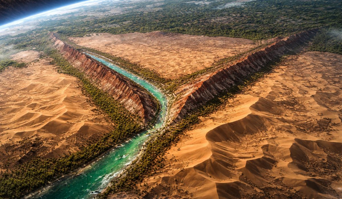
A satellite image revealed a rare pattern in the Taklamakan Desert, where relief, water, jade, and vestiges of an ancient military fort intersect at the same point in the landscape in western China.
A satellite image captured over the Taklamakan Desert in western China highlighted a “Y” formation at the confluence of the Hotan River and the Marztagh mountain ridge.
At the same point are the ruins of Mazar Tagh, a military fort dating back to the 8th century, in an area associated with the circulation of trade routes in Central Asia.
The Taklamakan is located in the Tarim Basin, in the Chinese region of Xinjiang, and covers about 337,000 square kilometers.
-
The Pacific Ocean reveals what the cliffs of Big Sur have hidden for millennia: Pfeiffer Beach, in California, features swirling purple sand formed by garnet crystals and displays a stone arch that is illuminated by the sun in winter for just a few days each year.

-
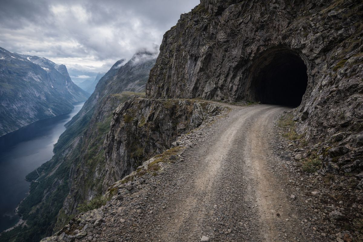
Aursjøvegen in Norway is a 100-kilometer gravel road that crosses chasms and dark tunnels carved into the rock at an altitude of 947 meters in the fjords and is only open for four months a year.
-
With about 4,000 m², the building constructed in a traditional neighborhood in France looks like a rainbow, has a colorful facade, mixes vibrant glass, and creates one of the most unusual visuals in Bordeaux.

-
Forget sapphire and topaz because there is a blue aluminum borate crystal that is worth 2 thousand dollars per carat and is only found in gem quality in the mountains of Namibia in a completely artisanal mining operation.

In studies and recent reports, the area appears linked to both the extreme aridity conditions and projects to combat desertification in the surrounding desert.

How the “Y” shape appears in the landscape
The shape observed from space results from the meeting of two natural features.
The Hotan River, also called Khotan, flows through the desert from south to north for about 290 kilometers.
Marztagh is described by NASA as an elongated formation, resembling a rocky wall, that rises about 180 meters above the dunes and extends up to 145 kilometers northwest.
In the image, the river appears in greenish tones due to the vegetation growing between the channels.
Next to it, the rocky ridge stands out due to the alternation between reddish bands, linked to iron-rich rocks, and lighter layers of sandstone.
In Chinese, the formation is also called Hongbaishan, which means “red and white mountain”.
There is also a direct impact on the surrounding relief.
Marztagh acts as a natural barrier to wind-blown sand, favoring the formation of crescent-shaped dunes known as barchans, especially on the northern edge of the ridge.
The Hotan River and the historical presence of jade
Besides the pattern, the Hotan is known for its historical relationship with nephrite.
Fed by the melting snow from the Kunlun Mountains to the south of the desert, the river is associated with the presence of white jade and green jade, materials valued for centuries in the region.

This set of characteristics helps explain the historical relevance of the area.
The presence of water, relative shelter from advancing sand, and access to mineral resources transformed this stretch of desert into a support point for movements and trade exchanges.
The strategic point on the Silk Road
The area where the river and ridge meet was integrated into the network of paths that later became known as the Silk Road.
Rather than a single road, it was a system of routes connecting different regions of Asia over several centuries.
In this context, the location provided practical conditions for circulation and surveillance.
It was there that Mazar Tagh was established, a military fort built on top of an elevation at the vertex of the “Y”.
The site is associated with the Tibetan Empire, which existed between 618 and 842 AD and exerted influence over vast areas of the Tibetan plateau and neighboring territories.
What was found at Mazar Tagh
Today, the site preserves remnants of the ancient fortification and has become a reference for the study of human occupation in this part of Central Asia.
The most well-known excavation was conducted in 1907 by the Hungarian-British archaeologist Aurel Stein.
During the work, more than 1,500 fragments of documents on wood and paper were located.
According to the International Dunhuang Programme, the texts appear in languages such as Khotanese, Uighur, and Sogdian, indicating the linguistic diversity of the area and the administrative and military role of the post.

The excavations also recovered everyday objects, including arrows, scabbards, shoes, dice, a comb, and a pen.
Part of this material is included in collections related to Stein’s legacy in the United Kingdom, including holdings from the British Museum.
Among the items most cited in the descriptions of the site is a painting of a “begging monk” on a wooden plaque.
According to reports associated with the find, the piece may have been produced by a soldier.
The material is often mentioned by researchers as indicating the coexistence, in the same space, of military activity and religious practices.
A hill with religious and historical layers
Before the establishment of the fort, the hill was already associated with a site of Buddhist pilgrimage, according to the International Dunhuang Programme.
Currently, the same point houses an Islamic sanctuary, which helps to illustrate the long symbolic and strategic occupation of the area.
The formation seen from space gained attention also for appearing during a phase of greater focus on the Taklamakan.
In recent decades, China has expanded vegetation belts and actions to combat desertification in the surrounding desert.
The Three-North Shelterbelt program, often referred to as the “Great Green Wall”, began in 1978, and Chinese state media reported in November 2024 the completion of a green belt of about 3,000 kilometers around the Taklamakan.

Recent research indicates that reforested areas in the vicinity have begun to function as carbon sinks during certain times of the year.
However, the studies address sectors influenced by reforestation and increased vegetation, not a uniform change throughout the core of the desert, which remains marked by extreme aridity conditions.
The image, therefore, brings together in a single frame geographical, historical, and archaeological data already documented.
In the center of the Taklamakan, the confluence of the river, rocky ridge, and the ruins of an 8th-century fort shows how a visible feature of the space can concentrate information about the environment, commercial circulation, and human occupation over time.


Seja o primeiro a reagir!