 Português
  Inglês
  Espanhol
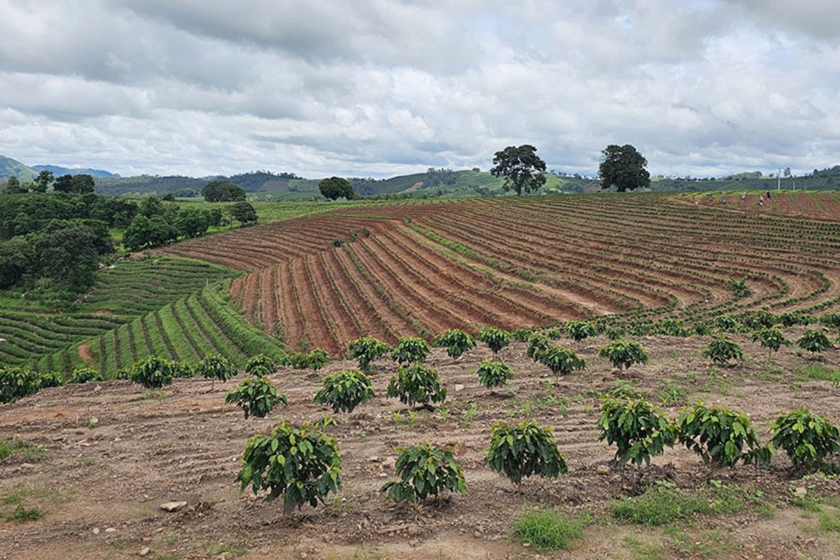
With High Precision and Support from Artificial Intelligence, Remote Sensing Redefines Coffee Monitoring, Strengthening Public Policies, Sustainability, and Rural Credit for Small Producers
The remote sensing is transforming the way Brazil identifies and manages coffee plantations, especially on small properties that were previously invisible to conventional mapping, according to a report published.
A team of Brazilian researchers developed an unprecedented method that combines Landsat and Sentinel-2 satellite images with artificial intelligence algorithms in agriculture, achieving over 95% accuracy in identifying cultivated areas.
The study showed that this combination allows for distinguishing up to four productive stages: formation, production, pruning, and renewal, with accuracy between 77% and 95%, even in fragmented and mountainous regions.
-
A bright yellow mushroom imported from Asia escaped from a cultivation farm in the United States in 2010 and is now aggressively spreading across 25 states, destroying entire communities of native fungi in American forests.
-
Buried under China, a colossal machine weighing 20,000 tons began operating as the largest neutrino detector on the planet and, in just 59 days, surpassed results that science took half a century to achieve.
-
Iran enters the center of a climate alert after the war emitted 5.6 million tons of CO2 in two weeks, surpassing the annual pollution of entire countries.
-
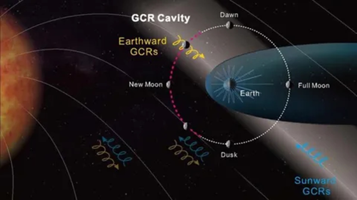
Lunar exploration may change after a Chinese probe finds a “cavity” of radiation that reduces the impact on astronauts by up to 20% at certain times on the Moon.
This innovation not only enhances the mapping of coffee plantations with AI, but also paves the way for public policies and climate monitoring strategies for coffee, which are essential in light of global changes affecting agricultural productivity.
Mapping of Coffee Plantations with AI Enhances Management and Rural Public Policies
The remote sensing technique employs public data from the Harmonized Landsat Sentinel-2 (HLS) program, analyzed by algorithms such as Random Forest and XGBoost.
The processing occurs in a hierarchical system of four levels: first, it distinguishes native vegetation from agricultural areas; then, it separates annual and perennial crops; next, it differentiates coffee plantations from eucalyptus plantations; and finally, it identifies the productive stage of each crop.
This methodology achieved over 96% accuracy in the first three levels and an average of 83% in the fourth, with a highlight on productive areas, which achieved 94% accuracy.
According to the researcher from Embrapa Digital Agriculture, Édson Bolfe, the challenge has always been to map small-scale productive areas with high resolution.
With the use of AI, it is possible to analyze dense time series and generate detailed diagnostics that guide agricultural policies and credit programs.
In Caconde (SP), where the method was tested, mapping of coffee plantations with AI provided unprecedented data on the area occupied by local coffee growing.
The president of the Rural Union, Ademar Pereira, emphasized that, for the first time, producers have a concrete reference to plan training and adopt management practices such as skeleton pruning and replanting, practices that renew the productive vigor of coffee.
Remote Sensing with Landsat and Sentinel-2 Satellite Images Increases Accuracy in Coffee Identification
At the heart of the methodology is the combination of Landsat and Sentinel-2 satellite images, which provide observations every three days with a very high level of detail.
The researchers used multispectral bands, spectral indices such as NDVI, GNDVI, NDWI, and SAVI, and texture metrics derived from GLCM to identify subtle variations in vegetation.
During the rainy season, when the main phenological transitions occur, the NDVI index proved especially effective in distinguishing coffee areas from other crops or pastures.
Doctoral student Taya Parreiras from Unicamp and a scholarship holder in the Semear Digital project explained that HLS images, especially the green band, were responsible for about 40% of the classification in one of the levels.
The use of surface temperature (LST) data also contributed to refining the differentiation between productive and skeletonized coffee plantations.
Although XGBoost and Random Forest showed similar results, the latter was up to 15 times faster in processing, making it more efficient for large-scale analyses.
These results reinforce the potential of remote sensing as a strategic tool for mapping perennial crops with a high level of detail and reliability.
Artificial Intelligence in Agriculture and Climate Monitoring of Coffee Strengthen Digital Agriculture in Brazil
The impacts of artificial intelligence in agriculture and climate monitoring of coffee go far beyond crop mapping.
In a global scenario of climate change, where suitable planting areas tend to diminish, accuracy in agricultural management becomes crucial for the sustainability and competitiveness of the sector.
The analyst from Embrapa Environmental Research, Gustavo Bayma, highlights that this methodology places Brazil at the forefront of digital monitoring by allowing a comprehensive understanding of the coffee cycle and anticipating management decisions.
In addition to facilitating access to rural credit and agricultural insurance, the system contributes to traceability required by international markets and strengthens agricultural governance.
All generated maps are available for free in the Embrapa Research Data Repository (Redape), which enhances transparency and access to information.
The researchers plan to expand remote sensing tests to multi-year series and develop new deep learning models that more accurately delineate plots, differentiating roads and native vegetation.
This advancement is an integral part of the digital agriculture project in Brazil, especially through the program Semear Digital, coordinated by Embrapa Digital Agriculture and funded by Fapesp.
The project created ten Agrotechnological Districts (DATs) in different regions, including Caconde, to bring producers closer to digital technologies and promote rural connectivity.
The proposal is to transform satellite data into practical tools for cooperatives, unions, and public agencies, directly supporting decision-making and boosting the sustainable development of coffee growing.
With remote sensing, the country enhances its capacity to understand and plan land use, strengthening family farming and ensuring its competitiveness in the face of climatic challenges.
The combination of AI, satellites, and public policies makes Brazil a global model of agricultural innovation, where science and sustainability meet to secure the future of national coffee.


Seja o primeiro a reagir!