 Português
  Inglês
  Espanhol
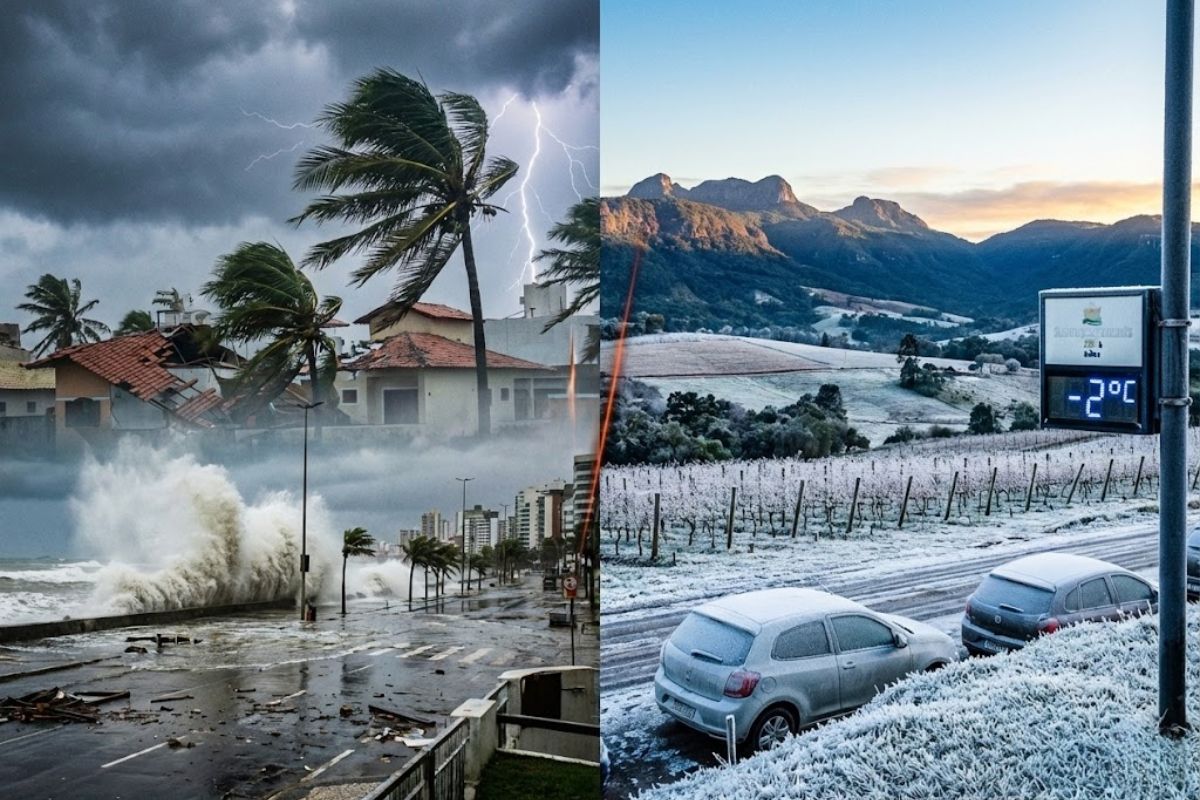
While Storms With Volumes of Up to 100 Millimeters and Gusts of 100 Km/h Advance Through 13 States and the Federal District, the South Faces Winter Cold, Frost in the Mountains, and Attention to Flooding This Wednesday 17, With Risk in Capitals and Mountain Areas of the Southeast and South Regions of Brazil.
The storms caused by a cold front are expected to hit 13 states and the Federal District this Wednesday (17), with heavy rain, volumes between 50 and 100 millimeters, and wind gusts that can reach 100 km/h, according to the National Institute of Meteorology (Inmet). The system also channels moisture coming from the Amazon, favoring the formation of an instability corridor that spreads rain-laden clouds across much of the country.
On Tuesday (16), strong storms already hit the state of São Paulo, putting the capital on alert due to intense rain during the afternoon. Now, the cold front is advancing and reinforcing the unstable weather this Wednesday (17), with potential for heavy rain, lightning, and strong winds in the Southeast, while the South begins to feel an out-of-season cold, resembling winter with even the possibility of frost in higher altitude areas.
Storms Spread From North to Central West
According to Inmet, the storms this Wednesday (17) are part of a large moisture corridor that originates in the Amazon and extends toward the Central West.
-
Omoda & Jaecoo and AiMOGA Robotics advance in industrial artificial intelligence with a strategic debut in Thailand and a focus on advanced automation.

-
In a scenario of rising fuel prices, Omoda & Jaecoo enhance value for consumers with a range of up to 1,200 km, energy efficiency, and a new concept of worry-free mobility.

-
Cement battery inspired by chemistry used since Ancient Rome resurfaces as a rechargeable thermal solution and enters the competition for the future of industrial heat.

-
Scientists have found in the dark depths of the North Sea giant marks from 18,000 years ago left by colossal icebergs, and the discovery could help predict the future of Antarctica.


This corridor increases instability and creates conditions for heavy rain showers, thunderstorms, and wind gusts in various parts of the country.
Meteorological models indicate instability over Mato Grosso do Sul and Mato Grosso, two of the most affected states in the Central West.
The combination of heat, high humidity, and the presence of the cold front creates the perfect environment for storm clouds, which can cause significant rain accumulations in a short time.
States Under Alert for Storms and Winds of 100 Km/h
In total, 13 states and the Federal District are at risk of storms this Wednesday.
The list includes: northern Paraná, São Paulo, Rio de Janeiro, southern Espírito Santo, Minas Gerais, Mato Grosso do Sul, Mato Grosso, Goiás, Tocantins, southern Pará, Rondônia, Amazonas, and Acre, as well as the Federal District.
In these areas, Inmet warns of rain volumes between 50 and 100 millimeters, accompanied by intense winds that can reach 100 km/h.
The combination of heavy rain and wind gusts increases the risk of fallen trees, roof damage, power outages, and sudden flooding in urban areas.
Therefore, meteorologists recommend that the population stay alert to official warnings and avoid exposure during periods of more intense rain.
Southeast Concentrates the Strongest Storms
In the Southeast, the cold front already showed strength on Tuesday (16), when the city of São Paulo faced storms and went on alert due to the intensity of the rain.
For this Wednesday (17), the most critical situation shifts to Rio de Janeiro, southern Espírito Santo, and southeastern Minas Gerais, which are expected to experience the most intense storms.
According to Inmet, daily rain accumulations may exceed 100 millimeters between Tuesday and Wednesday (17) in these areas, creating a high-risk scenario for flooding and landslides.
Climatempo reinforces that, in Rio de Janeiro, the weather is expected to remain unstable throughout the state, with significant rain and potential for flooding and landslides, especially in the Mountain Region.
The risk of storms also extends to parts of Minas Gerais, primarily the southern part of the state and the Zona da Mata Mineira, where the rain may be intense, accompanied by strong wind gusts and many lightning strikes.
In these regions, any heavy rain in a short period is sufficient to cause flash floods and problems on already fragile hillsides.
Winter Cold and Frost in the Southern Mountains
While storms advance over the Central West, Southeast, and parts of the North, the South of Brazil faces an opposite but equally concerning situation.
The same cold front that caused storms earlier in the week is now moving away and making way for a high-pressure system, responsible for stabilizing the weather but dropping temperatures.
The highlight this Wednesday (17) in the South Region is the unexpected cold for this time of year, as the country approaches summer.
Climatempo points out that temperatures are expected to have typical characteristics of winter, with the possibility of weak and isolated frost in the higher areas of the Serra Gaúcha and Serra Catarinense between dawn and early morning.
This contrast between storms in much of the country and winter cold in the South reinforces the extreme nature of the meteorological situation.
Reinforced Alert for Flooding and Landslides
With storms expected for 13 states and the Federal District and rain accumulations that may exceed 100 millimeters in parts of the Southeast, meteorological agencies are reinforcing the alert for flooding, flash floods, and landslides, especially in areas with rugged terrain and high urban density.
In cities like Rio de Janeiro and mountainous regions, the combination of heavy rain and saturated soils increases the risk of disasters, requiring heightened attention from the population and municipal civil defenses.
The recommendation is to follow official bulletins, avoid risk areas during intense rain, not to attempt to navigate floods with vehicles, and to seek safe places in case of signs of landslides, such as cracks in walls and slopes.
And you, how is the situation in your city, with these storms and the out-of-season cold in the South, have you noticed changes in the weather in recent days?


Seja o primeiro a reagir!