 Portuguese
  English
  Spanish
The end of March gains a new perspective as models indicate stronger cold in Brazil, snow in parts of Spain, and temperatures up to 10 degrees below average in areas of North America
The advance of a polar air mass begins to reshape the climate map in different parts of the world. The highlight is the rapid drop in temperatures, affecting regions of Brazil, advancing over Spain, and gaining strength in North America.
The impact is practically felt in daily life. There is a forecast of intense cold, possibility of snow, and frost formation, in addition to abrupt weather changes during a period that normally marks the transition of seasons.
Polar air mass advances over Spain and brings down temperatures in the week of March 26
Starting on March 26, a wave in the atmospheric flow allows cold air to enter the Iberian Peninsula. The movement displaces high-pressure systems and paves the way for a deep trough with polar characteristics.
-
Italian researchers have detected what appears to be a second Sphinx buried under the sands of Egypt, and satellite scans reveal a gigantic underground megastructure hidden beneath the Giza Plateau for over 3,000 years.

-
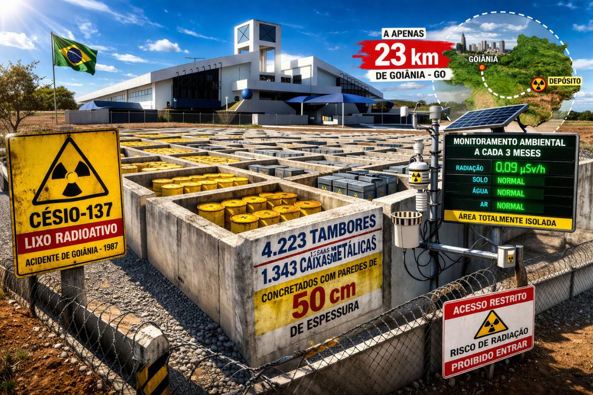
There are 4,223 drums and 1,343 metal boxes concreted with 50-centimeter walls that store the radioactive waste from Cesium-137 in the worst radiological accident in Brazil, just 23 kilometers from Goiânia, with environmental monitoring every three months.
-
Giant Roman treasure found at the bottom of Lake Neuchâtel in Switzerland reveals an advanced trade system, circulation of goods, and armed escort in the Roman Empire about two thousand years ago.

-
He buried 1,200 old tires in the walls to build his own self-sufficient house in the mountains with glass bottles, rainwater, and an integrated greenhouse.


The result is reflected in the thermometer. The forecast indicates negative temperatures at altitude and snow in mountain ranges, such as the Pyrenees, Cantabrian Mountains, and areas of the Iberian system, with a greater impact in the north of the country.
Models diverge on the intensity of cold in Spain, but confirm a scenario of temperature drop
There is divergence regarding the extent of the phenomenon. One scenario points to more intense and widespread cold, while another restricts the effects to the north, east, and regions close to the Mediterranean.
Even with differences, there is a common point. All scenarios indicate significant temperature drop and episodes of instability, reinforcing the risk of snow and adverse weather at the beginning of Holy Week.
Brazil enters the cold period with risk of frost and cooling in the South and Midwest regions
In Brazil, the advance of autumn brings the first incursions of cold air. The South and part of the Southeast regions are expected to record temperature drops and frost formation, especially in higher areas.
The impact also reaches the interior of the country. Episodes of cooling may reach the Midwest and advance as far as southern Amazon, altering the typical heat pattern in these regions.
North America registers cold pockets with temperatures up to 10 degrees below average
In the United States and Canada, the climate pattern shows contrasts. While part of the territory maintains high temperatures, specific regions face significant drops in the thermometer.
There are recent reports of temperatures more than 10 degrees below normal in cities in Canada, as well as signs of persistent cold in areas near the Great Lakes and the northeast of the United States.
Alaska stands out as one of the main foci of persistent cold on the continent
The state of Alaska appears as one of the areas with the greatest consensus among forecasts. The expectation points to continuously below-average temperatures, especially in the southern and southeastern regions.
This pattern reinforces the presence of cold air in the extreme north of the continent and helps maintain the thermal contrast in other areas of North America.
Holy Week concentrates the impact of cold and increases uncertainty about the weather
The period of Holy Week between March 29 and April 5 concentrates the most relevant effects in Europe. The combination of cold and instability coincides with a time of significant movement of people.
Despite this, there are indications of a change in the pattern. The trend is for a gradual return to more stable conditions in early April, although still with a high level of uncertainty.
The advance of polar air in different regions shows a fragmented climate scenario, with localized but intense cold. This behavior reinforces the difficulty of uniform forecasts and highlights the importance of following constant updates.
The overall reading points to a transition period marked by specific extremes. Cold does not dominate the planet, but emerges strongly where models converge the most and alters the daily lives of millions of people.
Sources: AEMET, portal.inmet.gov.br, cpc.ncep.noaa.gov, weather.gc.ca


Seja o primeiro a reagir!