 English
  Francês
  Alemão
  Italiano
  Japonês
  Norueguês
  Portuguese
  Spanish
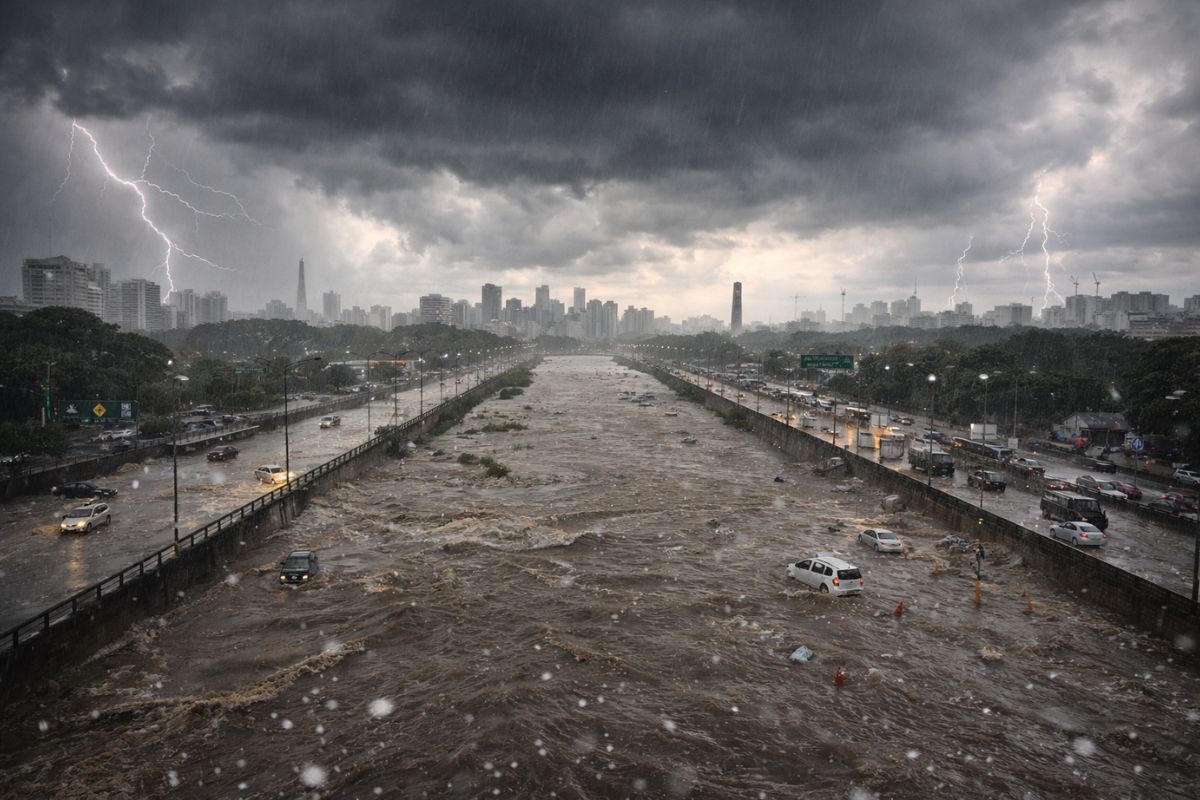
The Civil Defense placed all regions of São Paulo on alert for flooding at 2:58 PM this Thursday (26) after heavy rain caused by the combination of heat with sea breeze, with a severe alert that includes the risk of hail, overflow in the Tietê and Pinheiros margins, and gusts of wind in the capital
The Civil Defense of São Paulo issued a severe alert for heavy rain in all regions of the capital this Thursday (26). The alert for flooding was activated at 2:58 PM and simultaneously covers the North Zone, East Zone, West Zone, Southeast Zone, South Zone, Downtown, Tietê Marginal, and Pinheiros Marginal. The alert includes the risk of lightning, hail, overflow, and gusts of wind in a situation that put the entire city on alert at the same time.
According to the Climate Emergency Management Center (CGE) of the City Hall of São Paulo, the instabilities were caused by the combination of heat with the entry of the sea breeze. The images from the weather radar showed heavy rain in Downtown and the Southeast and South Zones, particularly in the subprefectures of Vila Mariana, Jabaquara, Santo Amaro, Cidade Ademar, and Capela do Socorro. The trend for the coming days, however, is for dry and sunny weather, with no rain forecast for Friday (27) and Saturday (28).
What the severe alert from the Civil Defense means in practice for São Paulo
When the Civil Defense issues a severe alert for all regions of the city at the same time, it indicates that the meteorological threat is not restricted to a specific neighborhood or zone.
-
Goodbye plastic in water: teenager creates a filter that removes 95.52% of microplastics, reuses 87.15% of magnetic ferrofluid, and rivals traditional systems in a compact high-efficiency home prototype.

-
Goodbye to traditional outlets: the new system requires no construction and allows up to 10 modules per track with USB-C, overload protection, and installation in minutes, transforming homes and eliminating dangerous extensions.

-
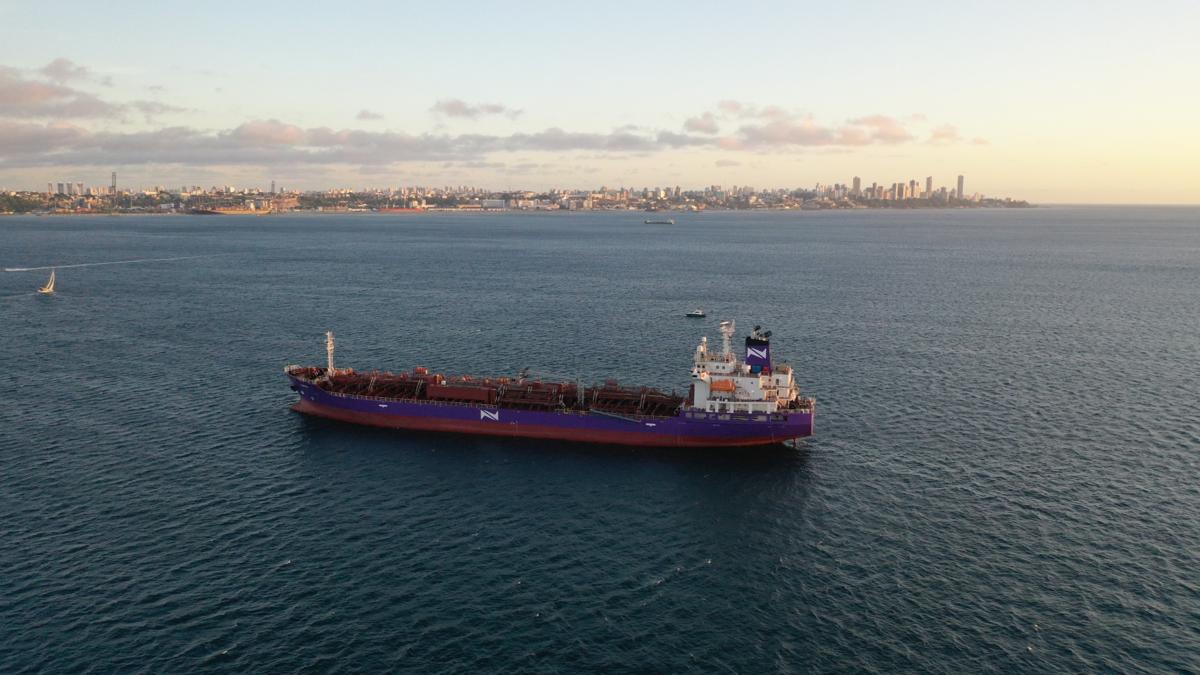
Norsul achieves CAP 1 classification with the chemical ship Taruca after dry docking and reinforces operational excellence in maritime transport.
-
China discovers a mega reserve with 10.4 million tons of rare earths and could redefine global dominance in technology, clean energy, and the military industry with 27.1 million tons of fluorite and 37.2 million tons of barite.


Heavy rain affects the capital in a widespread manner and the risk of flooding is real in any part of the city. In this condition, the guidance is to avoid unnecessary travel, not to cross flooded streets, and to stay away from streams and rivers.
The alert activated by the Civil Defense also means that emergency teams are positioned at strategic points and that monitoring systems are operating in enhanced mode.
The Tietê and Pinheiros margins are monitored with special attention because historically they are the most vulnerable roads to overflow during heavy rains in the capital. Drivers traveling on these roads should exercise extra caution and follow real-time updates.
Why did the heavy rain hit all regions of São Paulo at the same time
The CGE of the City Hall of São Paulo explained that the heavy rain this Thursday was caused by a recurring phenomenon in the São Paulo summer: the combination of heat accumulated throughout the day with the entry of the sea breeze from the coast.
When these two air masses meet over the city, the thermal shock generates intensely developing clouds, capable of producing heavy rain, hail, and gusts of wind in a short period of time.
This mechanism explains why the Civil Defense needed to issue the alert for all regions simultaneously.
Unlike localized convective rains, which hit one zone at a time, the entry of the sea breeze creates a front of instability that spreads throughout the capital of São Paulo.
The weather radar of the CGE identified heavy rain especially in Downtown and the Southeast and South Zones, but the potential for flooding extended to any region of the city.
Which regions and roads of São Paulo entered a state of alert
The Civil Defense activated the alert for flooding at 2:58 PM for eight simultaneous areas: North Zone, East Zone, West Zone, Southeast Zone, South Zone, Downtown, Tietê Marginal, and Pinheiros Marginal.
It is rare for all regions of the capital to be on alert at the same time, which reinforces the severity of the meteorological event recorded this Thursday.
The subprefectures most affected by the heavy rain include Vila Mariana, Jabaquara, Santo Amaro, Cidade Ademar, and Capela do Socorro, all in the southern and southeastern portion of the capital. These are regions with a history of recurring flooding, where soil impermeabilization and proximity to streams amplify the effects of the rain.
The Tietê and Pinheiros margins received a specific alert due to the risk of overflow from the rivers, which in heavy rain events can reach maximum flow levels and invade the lanes.
What to do when the Civil Defense issues a severe alert in São Paulo
When the Civil Defense issues a severe alert, the main recommendation is to avoid leaving home, especially during the peak of the rain.
Those who are on the street should seek shelter in elevated places, never cross flooded streets on foot or by car, and keep a distance from poles, trees, and electrical wiring. Currents of seemingly shallow water can have enough force to sweep away vehicles and people.
Drivers traveling on the Tietê and Pinheiros margins should follow real-time updates from the Civil Defense and CGE. If the water begins to rise on the lanes, the guidance is to abandon the vehicle immediately and move to a higher point.
The Civil Defense of São Paulo provides alerts via SMS at the number 40199, and residents can follow the situation through the CGE app and the official social media channels of the City Hall.
Forecast for the coming days indicates dry weather in São Paulo
Despite the severity of the heavy rain this Thursday, the weather forecast for the coming days in São Paulo is for dry and sunny weather.
There is no rain forecast for Friday (27) and Saturday (28), which should allow time for flooding points to normalize and for Civil Defense teams to assess any damage caused by the event this Thursday.
The alternation between days of intense heat and short-duration heavy rains is a typical characteristic of the end of summer in São Paulo.
Even with a forecast of dry weather, the Civil Defense recommends that residents of risk areas remain permanently alert, as new instabilities can form without warning when heat accumulates over the city again.
The severe alert from the Civil Defense for all regions of São Paulo this Thursday is yet another episode that highlights the capital’s vulnerability to heavy rains.
Flooding, overflow on the margins, and hail are not new, but the frequency with which these events paralyze the largest city in the country raises urgent questions about urban infrastructure and drainage.
Were you caught in the heavy rain this Thursday in São Paulo? How was the situation in your neighborhood? Does the Civil Defense manage to alert the population in time? Leave your account in the comments and share this article with those who need to prepare for the next alerts.


Seja o primeiro a reagir!