 Portuguese
  English
  Spanish
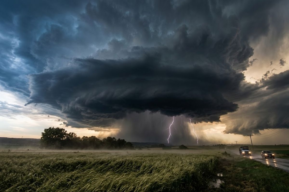
With an orange danger alert this Monday (23), Inmet points to rains that can reach 100 mm per day and gusts between 60 and 100 km/h, affecting 17 states. The scenario involves flooding, falling trees, electrical discharges, and power interruptions, with instability advancing through regions of the country.
The week begins with 17 states under an orange alert of “danger,” with forecasts of intense rain and strong winds capable of causing rapid disruptions, especially in urban areas. The central point is the combination of high water volume in a short time and gusts that increase the risk of falling trees and damage to the electrical grid.
In addition to the direct impact, the alert also requires attention to the weather behavior throughout the day, because instability can vary by region and by area of the territory. On days like this, the difference between a “rainy” day and a day of risk lies in the intensity, duration, and strength of the wind, factors that determine the chance of flooding, falling branches, and power outages.
What does the orange alert mean and why does it change the level of attention

Inmet works with three levels of alert: yellow (potential danger), orange (danger), and red (great danger). Being under an orange alert indicates that the predicted weather situation is risky and requires constant monitoring, as conditions may favor occurrences such as flooding, falling trees, and electrical discharges.
-
In a flooded well, archaeologists found a 1,700-year-old Roman egg that still contains clear and yolk intact inside the very thin shell.

-
Something is happening around the Earth: Inside the huge explosion of fireballs in 2026

-
A hot air bubble coming from Argentina expands over Brazil, causing thermometers to exceed 38 degrees with a thermal sensation of 40 degrees in late March, affecting 6 states at once.

-
The radish leaf that almost everyone throws away has more polyphenols, flavonoids, and fiber than the consumed root, and a 2025 study showed that the leaf contains compounds that protect the intestine, combat inflammation, and may inhibit the growth of cancer cells.

In practice, the orange alert is not a “confirmed that it will happen everywhere,” but a signal that there is a relevant chance of impacts in areas within the states indicated. That’s why following local updates makes a difference: the same instability can affect neighborhoods unevenly, depending on terrain, urban drainage, and exposure to wind.
The risk map: which states appear in the path of the rains and wind
In the South, the forecast indicates impact in Rio Grande do Sul, Santa Catarina, and Paraná, in almost the entire extent, except for the coastal strip. In these states, the presence of instability associated with the advance of a cold front tends to concentrate episodes of heavy rain and gusts, increasing the risk of falling trees and power interruptions.
In the North, the alert reaches all of Acre, the northern part of Rondônia, the southern half of Pará, and most of Amazonas. In the Northeast, the path of the rains includes Maranhão, Piauí, and parts of Bahia (north and west). These cuts within the states are important because they indicate that the risk condition may be more intense in certain areas, even when the capital or the coast is not at the center of the alert.
Central-West and Southeast: more localized instability, but with potential for disruption
In the Central-West, Tocantins appears entirely under alert, along with the north of Mato Grosso and a small strip in the north of Goiás. When the predicted rain is heavy, the effect can be immediate: streets with saturated drainage flood more quickly, and strong winds increase the risk of falling branches and exposed structures, especially in open areas.
In the Southeast, the indicated impact is more localized: south of São Paulo and north of Minas Gerais and Espírito Santo. Mato Grosso do Sul also enters the scenario with rain forecast in the southern portion. Even when the alert only covers part of the states, daily life can be affected by temporary blockages, power outages, and the need to exercise extra caution in traffic.
Why 100 mm in one day and strong winds trigger flooding and power outages
Rains of up to 100 mm per day represent a high volume concentrated in a short time, which favors rapid flooding in urban areas, especially where drainage systems already tend to fail. When this volume falls intensely, the water tends to flow strongly, accumulate in low points, and invade roads, with a direct impact on transportation and the functioning of services.
Added to this, gusts between 60 and 100 km/h increase the risk of falling trees and branches, as well as damage to wiring and structures. It is the combination that makes the scenario more critical: heavy rain increases soil vulnerability and the chance of saturation, while strong winds raise the probability of falls and power interruptions in the affected states.
Safety recommendations: what to avoid when the forecast indicates gusts and electrical discharges
With strong winds, the recommendation is to avoid parking vehicles near transmission towers and billboards, which can be more dangerous in case of instability. It is also advised not to seek shelter under trees, as gusts can break branches and increase the risk of accidents, especially during more intense downpours.
Another important measure involves electrical discharges: during gusts and storms, it is ideal not to use electronic devices plugged into the outlet to reduce the risk of damage from surges and discharges. Small preventive decisions often have a great effect on alert days, and this applies in all states and regions where instability intensifies.
With 17 states under an orange alert, a forecast of rain that can reach 100 mm per day, and winds of up to 100 km/h, the week begins requiring extra attention to what changes quickly: the intensity of the rain, the strength of the gusts, and local warnings.
The difference between shock and prevention often lies in following updates and avoiding obvious risk situations, such as trees, exposed structures, and unnecessary use of electronics plugged in during storms.
With information from the portal NDMAIS.
And in your city, within these states or near areas of instability, what has already changed in the routine today: traffic, power, fear of flooding or falling trees? Share where you are and what precautions you think work best when the orange alert comes into play.


Seja o primeiro a reagir!