 Portuguese
  English
  Spanish
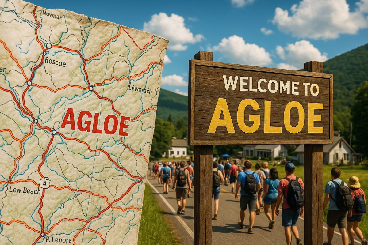
Created by a Cartographer Solely to Protect His Copyrights, the Fake City of Agloe Became a Real Place When Travelers Started to Visit It, Confusing Fiction with Geography
The story of Agloe, a small locality in the Catskills mountains of New York, is one of the most curious episodes in modern cartography. What began as a simple copyright trap on a map, created by a cartographer to prevent plagiarism, ended up transforming into a real city, albeit by accident, when people began to visit the site believing it actually existed.
This city is the classic example of the concept of “paper town”, intentionally created on maps as a way to identify unauthorized copies.
The case of Agloe, however, exceeded the paper and showcased the power that repeated information can have to bring into existence a place that never existed.
-
Italian researchers have detected what appears to be a second Sphinx buried under the sands of Egypt, and satellite scans reveal a gigantic underground megastructure hidden beneath the Giza Plateau for over 3,000 years.

-
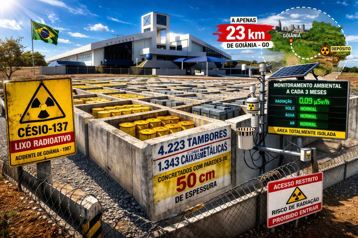
There are 4,223 drums and 1,343 metal boxes concreted with 50-centimeter walls that store the radioactive waste from Cesium-137 in the worst radiological accident in Brazil, just 23 kilometers from Goiânia, with environmental monitoring every three months.
-
Giant Roman treasure found at the bottom of Lake Neuchâtel in Switzerland reveals an advanced trade system, circulation of goods, and armed escort in the Roman Empire about two thousand years ago.

-
He buried 1,200 old tires in the walls to build his own self-sufficient house in the mountains with glass bottles, rainwater, and an integrated greenhouse.


What Is a Paper Town
The term “paper town” describes false geographical points inserted in maps as a mechanism for copyright protection.
This technique has been used since the 19th century by cartographers who wanted to identify plagiarism: if another map reproduced the same non-existent information, it would be evident that the work had been copied.
These “phantom marks” could be invented streets, villages, or rivers, usually placed in little-known areas.
In the case of Agloe, the trick ended up getting out of control, showing how blind trust in maps can give rise to unexpected realities.
How Agloe, the Fake City That Became Alive, Was Born
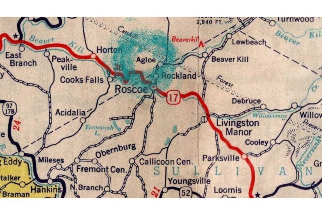
In 1925, the General Drafting Company, responsible for the official maps of Standard Oil, decided to insert a made-up city called Agloe at a crossroads of rural roads in northern New York State.
The name was an anagram of the initials of the map creators, Otto G. Lindberg and Ernest G. Alpers.
Years later, in the 1950s, a competing company, Rand McNally, published a new map of the region that also included Agloe.
The General Drafting accused its rivals of plagiarism, believing it was impossible to include the same fake city by coincidence.
But Rand McNally’s defense was surprising: Agloe had become real.
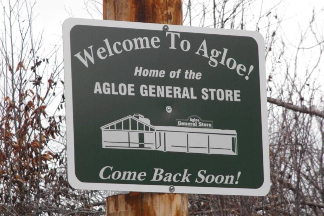
Over the years, drivers who saw the name on the map began to visit the area, and local merchants seized the opportunity to open a gas station and a general store named “Agloe General Store”.
Thus, the fictional city spontaneously transformed into a legitimate geographic point.
The Confusion Between Map and Reality
The case of Agloe revealed how human perception can transform fiction into reality.
In the 1950s, a name printed on a map had enough authority to attract travelers and even inspire businesses.
For a while, Agloe officially appeared on maps from different publishers and was even considered a recognized locality in Delaware County.
The episode also raised legal debates about the boundary between intellectual creation and the physical world.
Since the original map invented the name, but human presence made it real, neither side could claim full ownership of the place.
In the end, Agloe remained as a curious fusion of cartographic invention and social consequence.
Other Fake Cities and the Cultural Legacy of Agloe
Agloe was not the only example of a fictional city that gained notoriety.
Decades later, Argleton, a supposed city in West Lancashire, England, appeared on Google Maps and caused worldwide confusion before being removed.
The case demonstrated that even with digital technology, the errors and tricks of cartography persist.
Furthermore, Agloe’s story surpassed the limits of geography and reached pop culture.
Writer John Green used the case as inspiration for the novel “Paper Towns”, which became a bestseller and was adapted into a movie in 2015.
In the work, Agloe symbolizes the fragility of human perceptions and the fine line between the real and the imagined.
A Symbol Between Fiction and the Physical World
Today, Agloe is considered a “paper ghost town.”
The gas station and the general store have disappeared, leaving only the intersection where the city would have existed.
Even so, the name continues to appear in publications, books, and articles about cartography, as a reminder that maps not only represent the world; sometimes they create it.
For scholars, Agloe has become a symbol of the relationship between information and reality.
The episode shows that a simple act of recording can transform imagination into fact, especially when we collectively believe in what we see even if it originated from an error or a protection strategy of intellectual protection.


-

-

-

-

-

10 pessoas reagiram a isso.