 Portuguese
  English
  Spanish
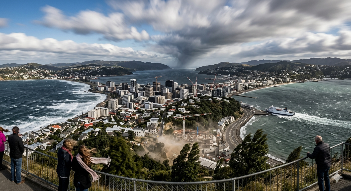
Wellington, in New Zealand, is the windiest city in the world, with extreme gusts and geography that channels winds between two oceans.
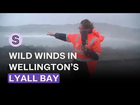
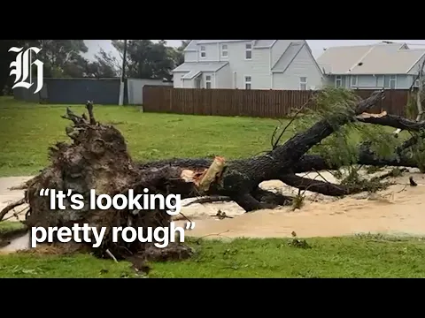
In October 2025, a storm with gusts exceeding 120 km/h swept through Wellington, canceling over 50 flights, uprooting trees, tearing roofs off houses, and leaving thousands of homes without power. A spokesperson for Air New Zealand told local media that it had been “one of the worst wind events of 2025”. He then added, with the nonchalance of someone describing a routine weather event: “The wind in Wellington is no surprise.” Indeed, it is not. According to data based on official meteorological records, Wellington, the capital of New Zealand, is considered the windiest city in the world, with an average annual speed of about 27 km/h. On average, the city records 173 days a year with gusts above 59 km/h, a speed that would already be classified as a gale in many regions of the planet. In its most extreme year, hurricane-force winds above 117 km/h were recorded on 233 days.
The highest gust ever recorded in the region reached 267 km/h in the Cook Strait on April 10, 1968, the same day a ship with hundreds of people on board was destroyed by the wind.
Why Wellington is the windiest city in the world
To understand why Wellington experiences such intense winds, it is necessary to look at the atmospheric dynamics of the Southern Hemisphere. Between latitudes 40° and 50° south lies a band historically known as the “Roaring Forties,” a zone of persistent westerly winds that circle the planet almost uninterrupted.
-
Italian researchers have detected what appears to be a second Sphinx buried under the sands of Egypt, and satellite scans reveal a gigantic underground megastructure hidden beneath the Giza Plateau for over 3,000 years.

-
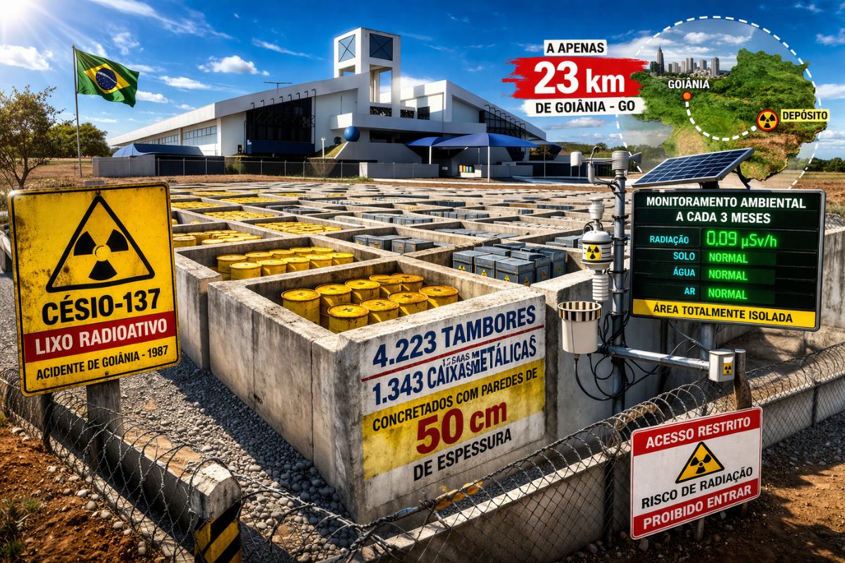
There are 4,223 drums and 1,343 metal boxes concreted with 50-centimeter walls that store the radioactive waste from Cesium-137 in the worst radiological accident in Brazil, just 23 kilometers from Goiânia, with environmental monitoring every three months.
-
Giant Roman treasure found at the bottom of Lake Neuchâtel in Switzerland reveals an advanced trade system, circulation of goods, and armed escort in the Roman Empire about two thousand years ago.

-
He buried 1,200 old tires in the walls to build his own self-sufficient house in the mountains with glass bottles, rainwater, and an integrated greenhouse.


These winds form from the pressure gradient between the tropics and Antarctica. Unlike the Northern Hemisphere, where large land masses interrupt and dissipate atmospheric circulation, the Southern Hemisphere has vast continuous oceanic expanses. This allows the winds to gain speed over thousands of kilometers without significant barriers.
Wellington is positioned exactly in this band, at a latitude of 41° south. However, the decisive factor is not just latitude, but local geography. The Cook Strait, which separates New Zealand’s North and South Islands, acts as a natural wind compression channel.
The mountain ranges of the two islands block the atmospheric flow. The strait becomes the only viable passage. The result is an acceleration effect similar to that of a squeezed hose: the air is forced through a narrow space, drastically increasing its speed. Wellington is positioned exactly at the exit of this corridor.
The effect of the Cook Strait and the amplification of extreme winds
The New Zealand Meteorological Service describes the phenomenon as a forced channeling process. Winds coming from the west encounter natural barriers such as the Tararua Range to the north and the Marlborough Range to the south, being compressed into the Cook Strait.
This concentrated flow behaves like a river of air being pushed through a geographical gorge. Upon exiting the strait, it reaches Wellington with maximum intensity. This explains why the city records gusts much more frequently than other nearby regions.
Comparative data shows the magnitude of the phenomenon. While Wellington records about 173 days a year with winds above 59 km/h, cities like Rotorua and Nelson, which have similar climates, record just over 30 days with such intensity. The difference lies not in the regional climate, but in the local geography.
The day the wind sank a ship in Wellington harbor
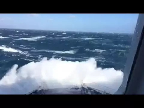
The most emblematic episode of the wind’s force in the city occurred on April 10, 1968. That morning, two storms met directly over the Cook Strait: the tropical cyclone Giselle coming from the north and a polar front advancing from the south.
The convergence of these systems generated an extremely intense storm, with gusts reaching approximately 275 km/h at some points. The impact on the city was immediate. Roofs were torn off, emergency vehicles overturned, and entire areas became inaccessible.
At that same moment, the ferry TEV Wāhine was attempting to enter the harbor with over 700 people on board. Conditions quickly became uncontrollable. Giant waves and extreme winds diverted the ship from its course, causing it to run aground on a reef.
After hours adrift, evacuation was ordered. Only part of the lifeboats could be launched due to the tilt of the vessel. Hundreds of people were swept to shore. In the end, 51 people died in the disaster, which became New Zealand’s largest modern maritime tragedy.
What it is like to live in the windiest city on the planet
Wellington is home to about 419,000 inhabitants and plays a central role in New Zealand’s politics, culture, and economy. Living in the city means coexisting with the wind as a permanent part of daily life.
The impact is direct in several areas. The city’s airport, with a relatively short and exposed runway, frequently suffers flight cancellations. The ferries crossing the Cook Strait are also regularly interrupted due to adverse conditions.
On the streets, gusts can knock down cyclists, drag objects, and turn structures into potential risks. In extreme events, authorities issue life-risk alerts, recommending that the population remain indoors.
On the other hand, the constant wind brings a positive side effect: the dispersion of pollutants. Wellington has significantly better air quality levels than cities with less atmospheric circulation.
Architecture and urban adaptation to extreme wind
The city has developed over decades an architecture adapted to climatic conditions. Traditional houses have been built with lower and more resilient structures, often positioned in areas protected by hills.
The region’s rugged topography creates distinct microclimates. In some neighborhoods, the wind is partially blocked, while in others, especially those facing the strait, the intensity is maximum.
This spatial variation requires specific construction and urban planning solutions, making Wellington a unique case of architectural adaptation to extreme wind.
Wind as a strategic energy resource in New Zealand
The same force that causes interruptions and risks has also become an energy asset. Wellington is home to important wind farms, such as West Wind and Mill Creek, which together total over 200 megawatts of installed capacity.
The combination of the Roaring Forties with the channeling effects of the Cook Strait creates one of the largest wind potentials in the world. Some turbines operate with a capacity factor exceeding 50%, one of the highest rates for onshore wind energy.
New Zealand has been expanding the use of this resource, consolidating wind as a fundamental part of its energy matrix.
The city built exactly where the wind intensifies
Wellington was not chosen despite the wind, but due to a combination of geographic and strategic factors. In 1865, commissioners responsible for defining the capital assessed the city’s central position, the quality of the harbor, and its connectivity between the two islands.
The wind was considered an inevitable cost. The location, however, offered decisive logistical advantages for the country’s administration. The city ended up being built exactly at the exit of one of the most intense wind corridors on the planet.
Among sailors of the Age of Sail, there was a well-known saying: “Below 40 degrees south, there is no law. Below 50, there is no God.” This phrase described the intensity of the winds in the Southern Hemisphere.
Wellington is at 41° south, exactly at the transition of this band. A point on the map where the atmosphere compresses, accelerates, and gains strength. The wind there is not an exception. It is the rule.


Seja o primeiro a reagir!