 English
  Francês
  Alemão
  Italiano
  Japonês
  Norueguês
  Portuguese
  Spanish
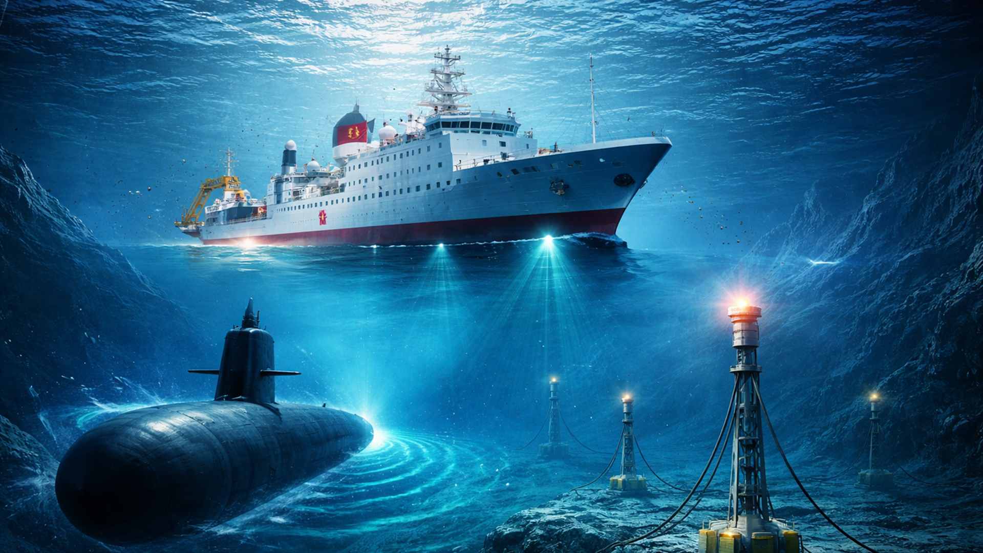
The expansion of China’s seabed mapping in areas near Taiwan, Guam, the Philippines, and strategic routes in the Indo-Pacific has intensified alerts among military experts, who see the collected data as a possible reinforcement for future submarine operations
The Chinese campaign to map the seabed in strategic areas of the Pacific, Indian, and Arctic Oceans has raised concerns among naval experts and officials linked to the United States Navy. The assessment is that the data gathered by research vessels may have direct utility in future submarine warfare operations against the U.S. and its allies.
In recent years, dozens of Chinese vessels have conducted surveys in sensitive maritime regions, including areas near Taiwan, Guam, and the Philippines. Although these missions are officially presented as research on climate, fishing, and underwater resources, analysts point out that the same information could also serve military purposes.
Submarine warfare relies on detailed knowledge of the underwater environment, including topography, pressure, temperature, salinity, and currents. These factors influence sonar behavior and can favor both safe navigation and the concealment of submarines in contested waters.
-
Seen from space, a colossal ‘Y’ cuts through the largest desert in China, blending a jade-filled river, red and white mountains, and revealing the absurd scale of the transformation of the Taklamakan surrounded by a green wall with billions of trees.

-
The Pacific Ocean reveals what the cliffs of Big Sur have hidden for millennia: Pfeiffer Beach, in California, features swirling purple sand formed by garnet crystals and displays a stone arch that is illuminated by the sun in winter for just a few days each year.

-
Aursjøvegen in Norway is a 100-kilometer gravel road that crosses chasms and dark tunnels carved into the rock at an altitude of 947 meters in the fjords and is only open for four months a year.

-
With about 4,000 m², the building constructed in a traditional neighborhood in France looks like a rainbow, has a colorful facade, mixes vibrant glass, and creates one of the most unusual visuals in Bordeaux.


Jennifer Parker, an associate professor of defense and security at the University of Western Australia and a former Australian anti-submarine warfare officer, told Reuters that the scale of the effort goes far beyond resource issues. According to her, the extent of the operation indicates an intention to develop an expeditionary naval capability for deep waters, also aimed at submarine operations.
Chinese ships expand surveys in strategic seabed areas
A detailed investigation by Reuters indicated that the Chinese campaign involves at least dozens of research ships operating in different oceans. The analysis of tracking data over more than five years identified that many of these vessels navigate in narrow patterns, similar to grids, associated with seabed mapping.
Among the cited cases is the Dong Fang Hong 3, operated by the Ocean University of China. The ship spent the years 2024 and 2025 conducting surveys in waters near Taiwan and Guam, as well as operating in regions of the Indian Ocean.
In October 2024, the vessel reportedly inspected ocean sensors installed near Japan and returned to the same location months later. In March 2025, it conducted a broad survey between Sri Lanka and Indonesia, covering maritime access routes to the Strait of Malacca, one of the main choke points for global navigation.
The university responsible for the ship describes its activities as climate research and sediment surveying. Nevertheless, naval analysts argue that the data collected in deep waters has evident military value, and Reuters reported that at least eight monitored vessels have mapped the seabed, while another ten carry equipment capable of performing the same task.
Peter Scott, former head of the Australian submarine force, told the agency that any military submariner will seek to understand as much as possible about the environment in which they operate. This knowledge, he said, can be crucial for understanding how sonar waves propagate underwater and thus influence the ability to detect adversaries or avoid detection.
Temperature, salinity, underwater topography, and ocean currents alter the behavior of sound waves. Therefore, detailed maps and environmental data are considered central components for planning and executing submarine operations.
Underwater sensors enhance surveillance in critical maritime regions
In addition to mapping, China has also been building a network of underwater sensors aimed at monitoring maritime conditions in strategic areas.
The concept, called “transparent ocean,” was proposed in 2014 by Chinese oceanographer Wu Lixin and envisions the installation of sensors, buoys, and systems capable of recording changes in the waters and underwater movements.
According to records from the Chinese government and academic institutions cited by Reuters, this system began with a focus on the South China Sea.
Later, the structure was expanded to the Pacific and Indian Oceans, with hundreds of sensors deployed east of Japan, near the Philippines, and around Guam.
Documents from Chinese scientific institutions also describe sets of sensors positioned in the Indian Ocean, in areas near India and Sri Lanka. Among the mentioned points is the Ninety East Ridge, an underwater mountain range located near the entrances to the Strait of Malacca.
Chinese researchers present these installations as tools for climate observation and oceanographic research. Nevertheless, some analysts believe they could also function as an early warning system to detect underwater movements in strategic maritime routes.
Rear Admiral Mike Brookes, commander of the U.S. Naval Intelligence Office, warned in testimony to a congressional committee that the data from this research allows for underwater navigation, concealment, and positioning of sensors or weapons on the seabed.
The statement reinforced American concerns about the possible dual-use of information collected in expeditions presented as civilian.
Civil-military fusion and strategic competition beneath the sea
The integration of scientific research and defense technology development is seen as part of the civil-military fusion strategy adopted by Beijing under President Xi Jinping. This model encourages collaboration between academic institutions and armed forces, bringing scientific activities closer to broader strategic objectives.
The advancement in the underwater domain occurs as China expands its naval capabilities and modernizes its submarine fleet.
The country already operates one of the largest submarine forces in the world and has been increasing the number of nuclear-powered submarines capable of conducting long-range patrols.
Analysts state that large-scale topographic surveying may help Beijing address a recurring strategic limitation.
The so-called First Island Chain, formed by territories controlled by U.S. allies and extending from Japan, through Taiwan, to Southeast Asia, is seen as an important barrier to Chinese maritime operations.
Peter Leavy, a former naval attaché from Australia to the United States, said that China shows strong concern about the possibility of being cornered in this area. For him, the mapping of the surrounding waters suggests an effort to better understand maritime dominance and thus gain conditions to break a potential blockade.
Activity has also been recorded near significant U.S. military centers, such as Guam and Hawaii, as well as routes leading to the Arctic. This region has been gaining strategic importance, and China has declared ambitions to become a “great polar power” by the 2030s.
For decades, the United States has maintained a significant advantage in oceanographic knowledge and underwater surveillance capabilities. However, experts warn that the rapid expansion of Chinese research and monitoring programs could reduce this gap and enhance Beijing’s ability to operate in decisive underwater environments.
Ryan Martinson, a specialist in Chinese maritime strategy at the U.S. Naval War College, told Reuters that the enormous scale of Chinese marine scientific research is surprising. If these programs are successful, they could provide China with a detailed picture of underwater environments in key areas, potentially impacting future disputes over control of the oceans.


Seja o primeiro a reagir!