 Portuguese
  English
  Spanish
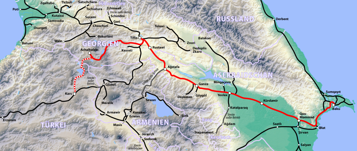
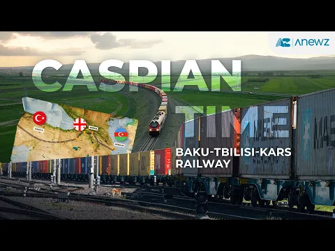
The Baku–Tbilisi–Kars Railway Connects Asia and Europe with 846 km of Tracks, Tunnels in the Caucasus, and Integration of Different Gauges Between Three Countries.
According to official statements from the governments of Azerbaijan, Georgia, and Turkey, as well as technical reports from national railway operators, the Baku–Tbilisi–Kars Railway (BTK) commenced operations in 2017 as one of the most strategic logistics projects of the 21st century outside the traditional Europe–Russia axis. The project was born with a clear goal: to create a continuous land railway corridor between Central Asia and Europe, bypassing historical geopolitical bottlenecks and tackling some of the most complex terrains in the Caucasus.
Unlike domestic lines, the BTK was designed from the outset as international infrastructure, requiring technical, legal, and operational harmonization among three countries with distinct railway systems, extreme climates, and severe mountainous terrain.
A 846 km Railway Crossing Three Countries
The Baku–Tbilisi–Kars Railway spans approximately 846 kilometers in total length, connecting the port of Baku on the Caspian Sea to the city of Kars in eastern Turkey. The route crosses the entire territory of Georgia and connects directly to the Turkish railway network, creating a physical link between the Caucasus and Europe.
-
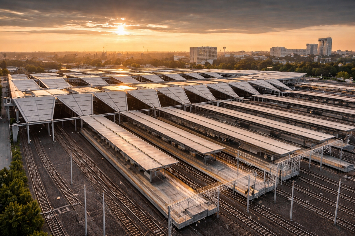
In A European City, The Country’s Largest Railway Junction Was Modernized Without Closing Its Doors, Kept Trains Running During Years Of Construction, Now Serves Up To 60,000 Passengers Per Day, And Installed Solar Panels That Generate About 30% Of Its Energy
-
Famous Brazilian Railway May Become a Parking Lot

-
The Country of “Punctual As a Train” Admits It Has Lost Control: High-Speed Trains Delay, Stop, Disappear from the Map and Turn 6-Hour Trips into 10, While Deutsche Bahn Promises Restructuring in 2026 But Faces 19th Century Infrastructure, Staff Shortages and Sections Closed for Months

-
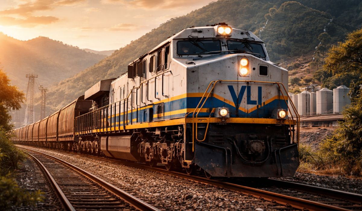
With an Investment of R$ 700 Million in One of the Country’s Main Rail Networks, VLI Reinforces Infrastructure, Receives 8 New Locomotives, and Expands the Corridor Connecting 7 States, Boosting Jobs and the Transportation of Grains, Ore, and Oil Products to the Port of Santos

Of the total, approximately 183 km correspond to entirely new sections, built specifically for the project, while the remainder involved heavy modernization of existing lines, with subgrade reinforcement, rail replacement, curve widening, and adaptation for heavier loads.
Railway Engineering in Mountainous and Seismic Terrain
The biggest technical challenge of the BTK lies in crossing the mountainous regions of the Caucasus, where the rugged terrain, geological instability, and seismic activity impose severe restrictions on the railway route. To overcome this environment, engineers resorted to railway tunnels excavated in rock, deep cuts on slopes, and viaducts designed to withstand extreme temperature variations and ground movements.
One of the most critical points is the railway tunnel between Tbilisi and Kars, approximately 4.4 km, built to allow direct crossing of the border in a high-altitude region, subject to heavy snowfall during winter. This section required drainage, ventilation, and structural reinforcement solutions compatible with international railway safety standards.
The Invisible Challenge of Incompatible Gauges
In addition to physical engineering, the BTK faced a rare operational problem: the integration of different railway gauges. Azerbaijan and Georgia use the wide gauge of 1,520 mm, inherited from the Soviet era, while Turkey operates with the standard European gauge of 1,435 mm.
To resolve this incompatibility, a specific infrastructure was built in Akhalkalaki, Georgia, including transshipment yards, bogie exchange systems, and logistics facilities capable of maintaining uninterrupted international cargo flow.
This point functions as a true “technical node” of the corridor, allowing the railway to operate on a continental scale despite the historical differences between the systems.
Cargo Capacity and Strategic Function
The railway was primarily designed for freight transport, although it also operates passenger services. In its initial phase, the capacity is around 6.5 million tons per year, with the potential to expand to up to 17 million tons annually as new investments are made in rolling stock and logistics terminals.
The BTK transports containers, industrial products, and commodities from Central Asia, especially Kazakhstan, in addition to cargo arriving by ship to the Caspian Sea. By connecting to the Turkish network, these loads continue to European markets by rail, reducing dependence on maritime transport and shortening trade routes.
A Railway That Redefines Logistics Maps
Before the BTK, a large part of the railway flow between Asia and Europe passed through northern corridors, crossing politically sensitive or excessively congested territories.
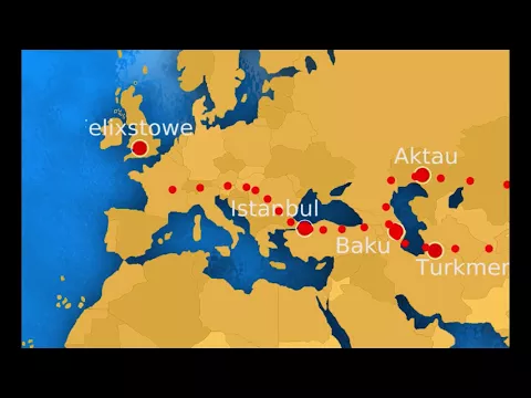
The new railway has created a functional land alternative, integrated into the so-called Middle Corridor of the New Silk Road, connecting China, Central Asia, the Caucasus, and Europe into a single logistics chain.
From a geopolitical standpoint, this explains Azerbaijan’s strong financial involvement in the project and Turkey’s strategic interest in establishing itself as a logistics hub between continents.
Engineering That Does Not Create Monuments but Alters Global Flows
The Baku–Tbilisi–Kars Railway is not distinguished by skyscrapers, iconic bridges, or works visible from a distance. Its impact lies in the ability to alter real economic flows, shorten routes, reduce risks, and integrate historically incompatible railway systems.
It is a clear example of silent heavy engineering, which traverses mountains, borders, and distinct technical systems to transform tracks into an instrument of continental reconfiguration.


-

-

-

-

12 pessoas reagiram a isso.