 Portuguese
  English
  Spanish
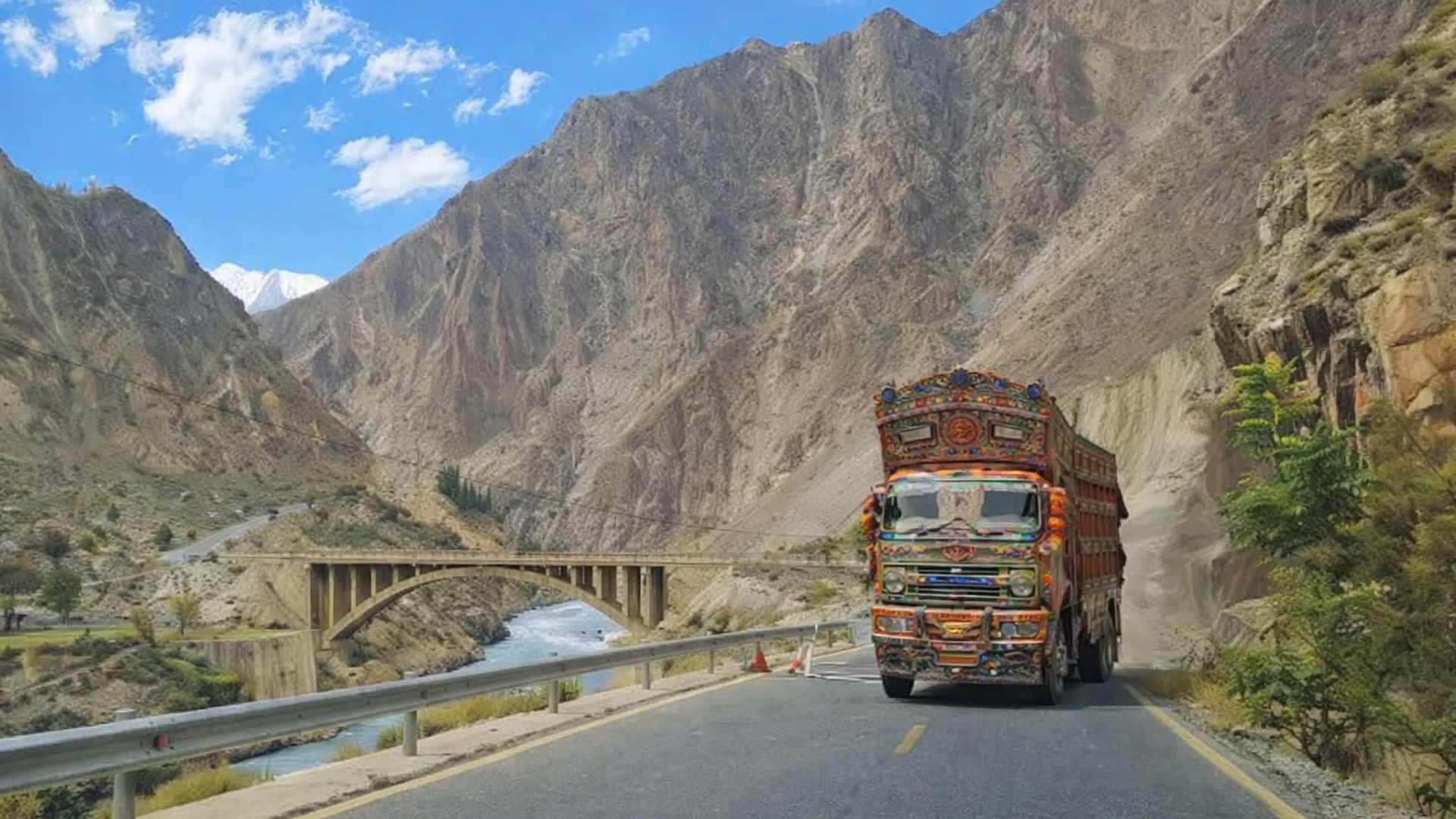


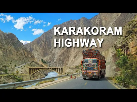
Considered one of the highest paved roads on the planet, the Karakoram Highway crosses extreme mountain ranges, connects China and Pakistan through glacial valleys and melting rivers, and sustains logistical, diplomatic, and touristic roles in one of the most unstable and elevated regions of the world.
The Karakoram Highway, known by the acronym KKH, traverses one of the highest and most unstable mountain regions on the planet by connecting Pakistan to China over approximately 1,300 kilometers.
Considered one of the highest paved roads in the world, the highway reaches approximately 4,714 meters at its highest point, near the Khunjerab Pass, where the highest paved border crossing is located at 4,693 meters.
Along the route, the road follows glacial valleys, melting rivers, and steep slopes, with sections carved directly into the rock.
-
Woman arrested after receiving $1.2 million due to banking error and not returning the amount.

-
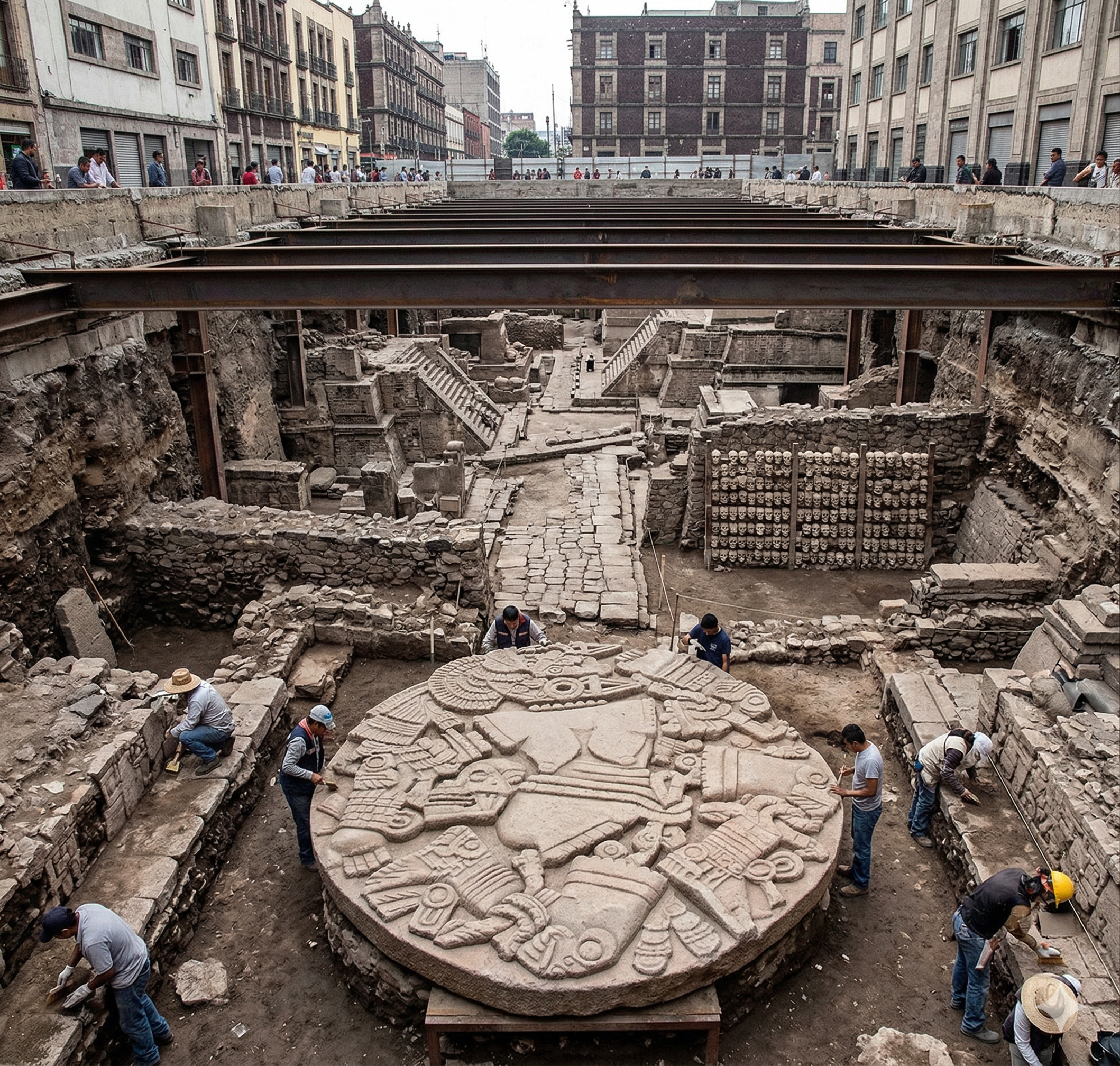
Beneath Mexico City lies an entire buried Aztec capital, and it all began when workers discovered a 3.25-meter stone disk featuring a dismembered goddess, revealing temples, skulls, and palaces beneath 22 million people.
-
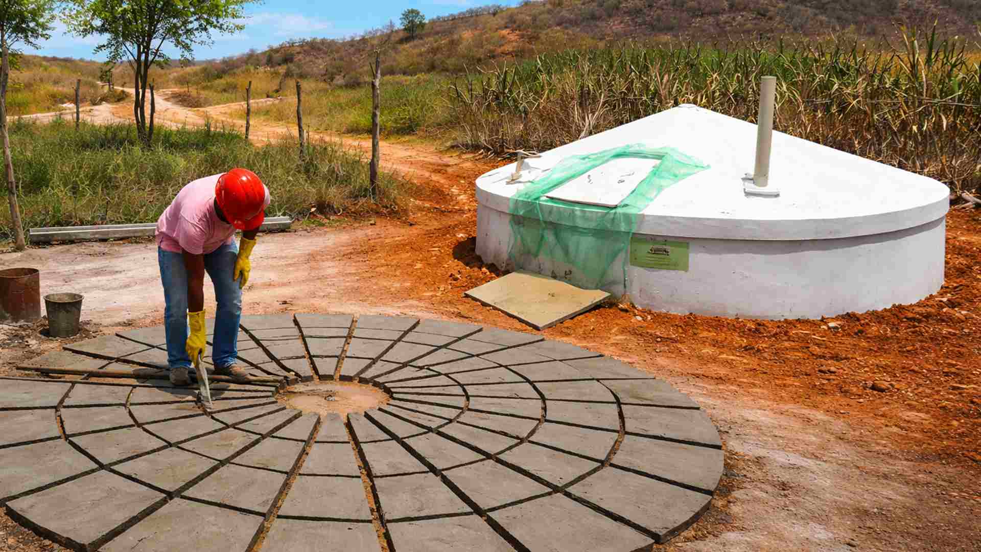
How to build a 35,000-liter cistern with 60 by 50 cm panels and rainwater for drinking and cooking without relying on water trucks or the city hall.
-
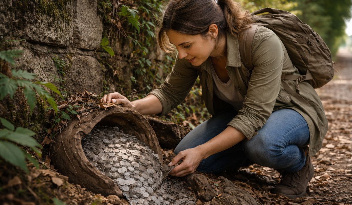
A woman went out for a regular walk and ended up finding a treasure buried for over 900 years, with more than 2,000 medieval silver coins compared by archaeologists to a lottery prize and considered one of the most significant finds in recent years in the country.

Extreme Altitude and Geography of the Karakoram Highway
The highway climbs to the 4,000-meter range in segments of northern Pakistan, already in Gilgit-Baltistan, before reaching the area of the Khunjerab Pass, on the line that separates the two countries.
This altitude places the KKH at a level comparable to famous mountains and effectively imposes conditions rarely found on paved international roads: thinner air, rapid temperature variations, and abrupt climate changes within a few kilometers.
On the other hand, the record attributed to the Karakoram Highway often appears in two measurements that circulate together.
The first is the altitude of the post and the crossing at Khunjerab, frequently mentioned for being a clear geographical reference.

The second is the maximum point of the road nearby, reported as around 4,714 meters, a value that reinforces the magnitude of the challenge of paving and maintaining a road in this environment.
Meanwhile, the surrounding scenery helps explain why the road has gained nicknames such as “the road that touches the sky.”
The path crosses the Karakoram system and areas near the Himalayas, where peaks above 7,000 meters can be seen from specific stretches, depending on the weather and visibility.
On clear days, snow-covered mountains, apparent glaciers, and rivers with greenish or turquoise hues, fed by thawing, appear.
Engineering in High Altitude and Permanent Risks
The Karakoram Highway did not originate as a tourist route: it was designed as a strategic link between two countries with integration and logistical interests.
Construction began in 1962, advanced for nearly two decades, and finished in 1979, before the road was opened to the public in 1986.
The construction period is cited as one of the most hazardous in modern road engineering, precisely because the terrain combines extreme altitude, avalanches, landslides, and barrier falls.
In several places, the feeling is of a track suspended between emptiness and the wall.
This is not just a figure of speech: segments were excavated into the slope, with deep cuts into the rock to create passage space, at a time when machinery was more limited than available today.
Still, the difficulty does not end with the inauguration.
Maintenance remains a central part of the routine, as the road is vulnerable to geological instability, flash floods, and the impacts of thawing.
The recent history of the route illustrates this risk.
In January 2010, a major landslide in the Hunza Valley blocked the Hunza River, formed Attabad Lake, and flooded a significant stretch of the highway, interrupting the land link along part of the route.
Since then, the region has had to deal with bypass solutions, realignments, and structures to restore the continuity of flow.
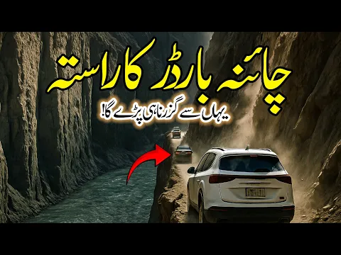
Strategic Importance for China and Pakistan
The KKH connects Hasan Abdal in Pakistan to Kashgar in the Chinese region of Xinjiang, linking stretches that also connect with the local road network on both sides of the border.
In Pakistan, the road is identified as National Highway 35 (N-35) and serves as the backbone for mountain communities that rely on it for the transport of people, food, and goods.
Furthermore, the Karakoram Highway has gained additional relevance by being integrated into infrastructure projects associated with the China-Pakistan Economic Corridor (CPEC), often cited as part of the Belt and Road Initiative.
In practice, this means that the highway is not just a path between mountains: it serves as a basis for modernizations, expansions, and logistical reorganization in a sensitive area from a geopolitical perspective.

In China, the road is referred to as the “Friendship Road,” a term that reinforces the diplomatic component of the endeavor.
Still, everyday use has a concrete face: cargo trucks, buses, and private cars share narrow lanes in stretches where, for long distances, there are no quick alternative routes.
In some valleys, the highway serves as the main access point and, at certain times of the year, the only functional route for supplies.
Adventure Tourism and Altitude Landscapes
Over time, the Karakoram Highway ceased to be seen solely as a logistical corridor and began to attract travelers interested in altitude landscapes and long travels through remote areas.
Cyclists and motorcyclists often choose stretches of the Hunza Valley and the surrounding Passu, where glaciers and rock walls come close to the road, creating observation points very close to the ice and mountains.
Among the most known stops is Attabad Lake, which has become an attraction following the landslide that created it.
Another common location in itineraries is Karimabad, in the Hunza Valley, cited for serving as a base for shorter trips and for providing views of the surrounding mountain ranges.
The experience, however, directly depends on the season and the weather.
Rapid weather changes affect visibility, temperature, and driving conditions.
Still, the road does not operate as a permanent postcard.
In several places, dense fog, strong winds, and sudden precipitation can change the route in minutes, helping explain why the KKH remains associated with both beauty and risk.
Climate, Altitude, and Care Along the Route
Traveling the KKH requires planning, as the highway may face blockages due to rockfalls, snow, and landslides, especially in winter and during periods of instability.
Even in summer, when tourist flow tends to increase, the weather in high mountains remains unpredictable, and long stretches may have few support services, such as workshops and stations.
Altitude also takes a toll.
Upon exceeding the mark of 4,000 meters, the thinner air can cause discomfort in sensitive individuals, especially when the ascent occurs rapidly.
For this reason, travelers often adopt a gradual ascent strategy, maintain hydration, and avoid intense exertion immediately upon reaching higher points.
Additionally, it is common to check vehicle conditions before entering more remote areas.
With a road that combines altitude records, strategic function, and ongoing maintenance against natural forces, the Karakoram Highway remains a symbol of integration and calculated risk in one of the world’s most complex borders.
To what extent can a route like this grow without hitting the limits imposed by the mountain itself?


Se fosse no Brasill uma estrada dessa nunca seria feita. O Brasil é um dos países c/ maiores perspectivas de se tornar um dos mais ricos e desenvolvidos do mundo,mas a corrupção nunca o transforma.
O rombo do Maste/BRB é um exemplo. Vai ser outro Anão do Orçamento, Mensalão, Petrolão, Lava Jato, Dinheiro nas Cuecas, Aeronaves, Emendas PIX/Secretas, ****, Barras de Ouro, Dinheiro nos Apartamentos e todos os tipos de corrupção possível, etc, etc…