 Portuguese
  English
  Spanish
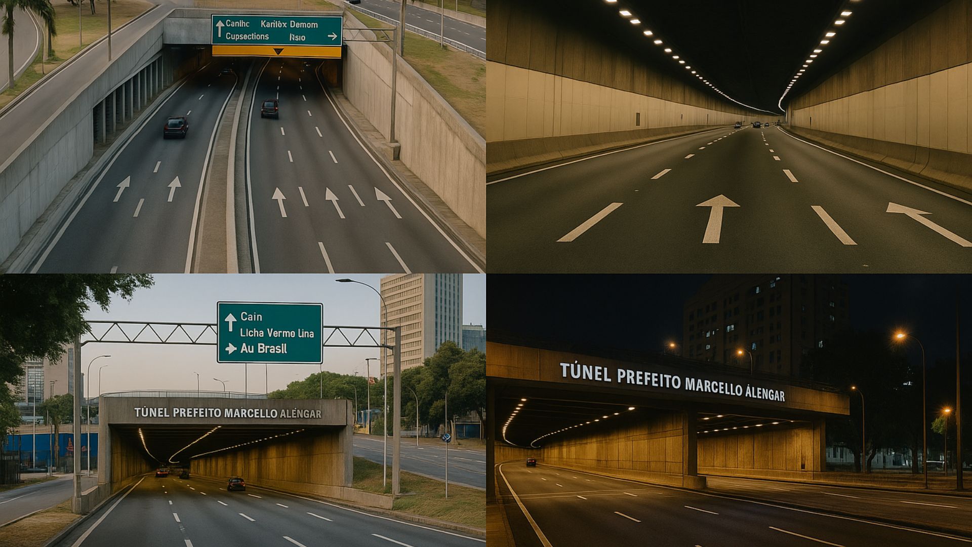


The Traffic Corridor Connecting Downtown Rio to the Metropolitan Area Includes the Largest Urban Tunnel in the Country and the Largest Bridge in Brazil, Forming One of the Busiest and Most Strategic Routes in the Fluminense Capital.
Rio de Janeiro brings together, in the same traffic axis, two of the most extensive terrestrial transport structures in the country.
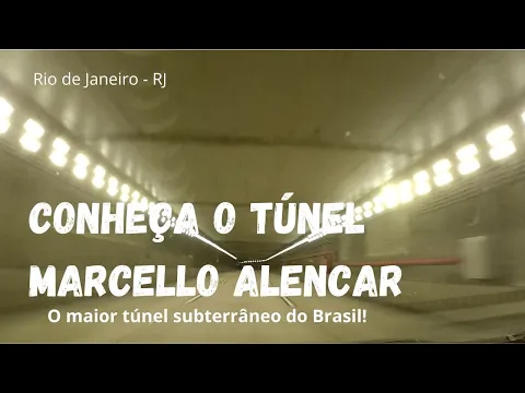
The Mayor Marcello Alencar Tunnel, at 3,382 meters, is classified by the government as the largest urban roadway tunnel in Brazil.
It connects the Rio-Niterói Bridge and Avenida Brasil to the Flamengo Park, forming a high-capacity underground corridor between the central region and the port area.
-
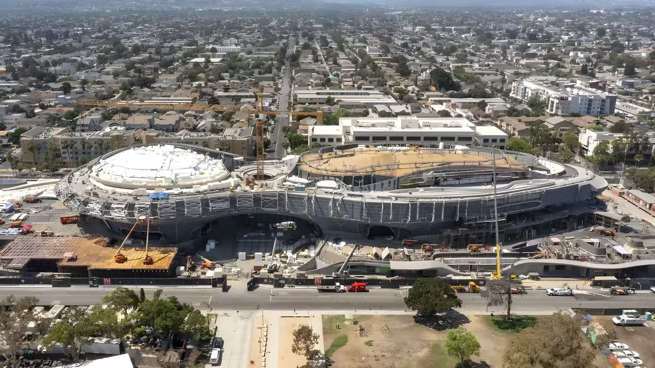
Created by George Lucas with over $1 billion, a futuristic museum in the shape of a spaceship with 1,500 curved panels is about to open in Los Angeles and will house one of the largest private collections of narrative art in the world.
-
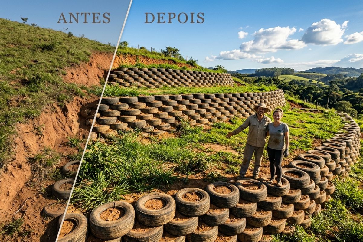
Couple shows how they built a retaining wall on their property using 400 old tires: sloped land turned into plateaus, tires are aligned, filled, and compacted with layers of soil, with grass helping in support and at almost zero cost.
-
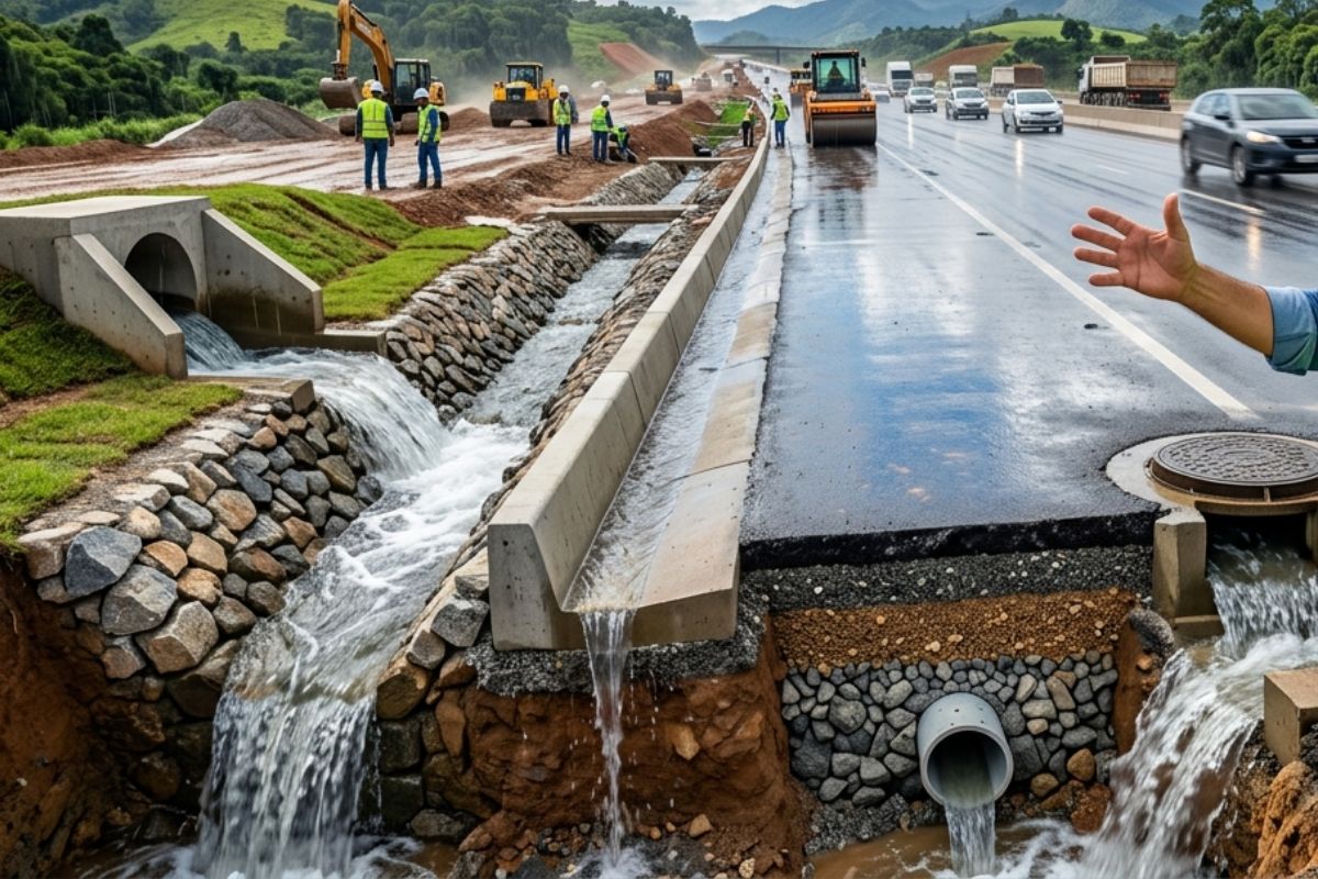
Engineer explains drainage during the rainy season: the difference between surface water and deep water, ditches, gutters, and water outlets on the road, as well as drains and drainage mattresses, to prevent erosion, aquaplaning, and flooding at the construction site today.
-
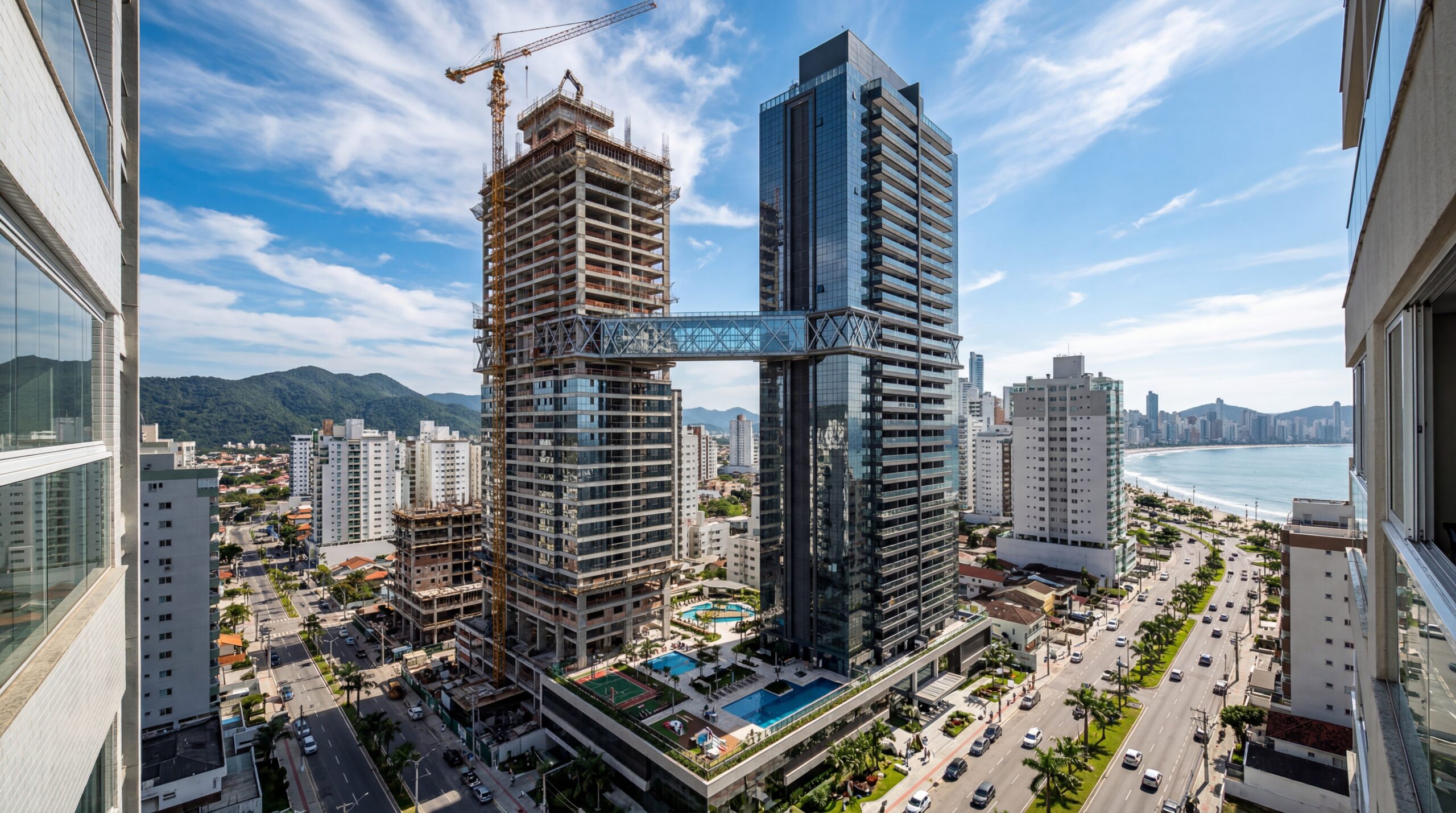
With 55 floors, 177 meters in height, a 15-meter walkway between the twin towers, ventilated facade, and 6,300 m² of leisure space, Ápice Towers already has one tower completed and another nearly at the top.
Strategic Connection Between Port, Downtown, and Flamengo Park
Built beneath the central area, the tunnel establishes a continuous passage between the port area and the waterfront of Flamengo Park, crossing the neighborhoods of Centro, Gamboa, and Saúde.
The path starts from an area near Caju and reaches Avenida Alfred Agache, in the region of Santos Dumont airport.
Technicians involved in the project state that this connection expanded the links between the accesses of BR-101, Downtown, and the southern waterfront.
The operation of the underground road allowed for the reorganization of the flow that was previously concentrated on the old Elevated Perimetral, which was deactivated and demolished as part of the Porto Maravilha project.

According to municipal authorities, the goal was to redistribute traffic and reduce congestion at critical points in the central network.
Tunnel Structure: Galleries and Traffic Capacity
The system consists of two parallel galleries. The Sea gallery, in the direction of Caju/Rio-Niterói Bridge, is 3,382 meters.
The Continent gallery, heading towards Flamengo Park/Southern Zone, measures 3,370 meters. In both, there are three lanes each, making six lanes in total.
Technical documents released at the time of inauguration indicated that the tunnel was designed to accommodate up to 110,000 vehicles per day.
According to operational data, having two galleries allows for maintaining flow during peak hours, although the current volume is not regularly disclosed.
Security and Monitoring Systems
The tunnel is equipped with fans, sensors, emergency bays, and a dedicated control room.
These equipment are part of the operation system of Porto Maravilha and the Rio Operations Center, which monitors traffic via cameras installed along its entire length.
Responsible technicians claim that the system allows for a quick response to incidents and adjustments to signage.
The maximum regulated speed is 80 km/h on straight sections. The complete crossing takes about two and a half minutes under normal conditions.

There are restrictions on the circulation of trucks, pedestrians, and cyclists, with specific exceptions for sports events authorized by the city hall.
Night maintenance windows are periodically performed and communicated by CET-Rio.
The Tunnel in the Context of Porto Maravilha
The Mayor Marcello Alencar Tunnel is part of the set of interventions for Porto Maravilha, which redesigned the area between Downtown and the port zone.
The removal of the Elevated Perimetral reconfigured surface traffic and opened space for new pedestrian circulation areas.
This change also allowed for the implementation of the VLT and the reurbanization of sections of the port waterfront. The first gallery began operation in 2016, after almost four years of construction.
A few days later, the second gallery was cleared for traffic, completing the underground axis that replaced the elevated connection.
The Rio-Niterói Bridge in the Metropolitan Axis
The President Costa e Silva Bridge, or Rio-Niterói Bridge, is about 13.29 kilometers long, making it the largest bridge in Brazil.
Inaugurated in 1974, it is part of BR-101 and establishes a direct connection between Rio and Niterói.
The crossing over Guanabara Bay receives, according to reports from the concessionaire, about 150,000 vehicles per day.
This traffic intensity reinforces the importance of integration with urban accesses on the Carioca side, including the Mayor Marcello Alencar Tunnel.
Integrated Corridor Between the Bridge, Avenida Brasil, and Flamengo Park
The junction of the bridge and the tunnel forms a continuous corridor that links dense areas of the Metropolitan Region.
Vehicles arriving via the Rio-Niterói Bridge have direct access to Avenida Brasil, the Linha Vermelha, and the underground axis towards Flamengo Park.
Urban mobility experts state that this configuration increases alternatives for movement and reduces dependence on traditional surface routes.
This set of interventions has redefined circulation in the port area and opened space for new urban uses, especially in the revitalized sections of Downtown.
With so many structural changes over the past decade, how do residents and users today perceive the impact of this integrated corridor on mobility routines?


Observe-se que o túnel Marcelo Alencar não é bem um túnel, mas grande parte dele é apenas uma vala com uma laje de concreto por cima.
Do fórum até o Morro de São Bento e sob a Av. Rodrigues Alves, até a nova via que liga a Av. Venezuela à rodoviária, ficam os dois trechos do suposto túnel.
Portanto, esses trechos não deveriam ser considerados para a qualificação como maior túnel urbano do mundo.
Sempre tem um pra **** regra
Sempre tem um pra k@@garr regra