 Portuguese
  English
  Spanish
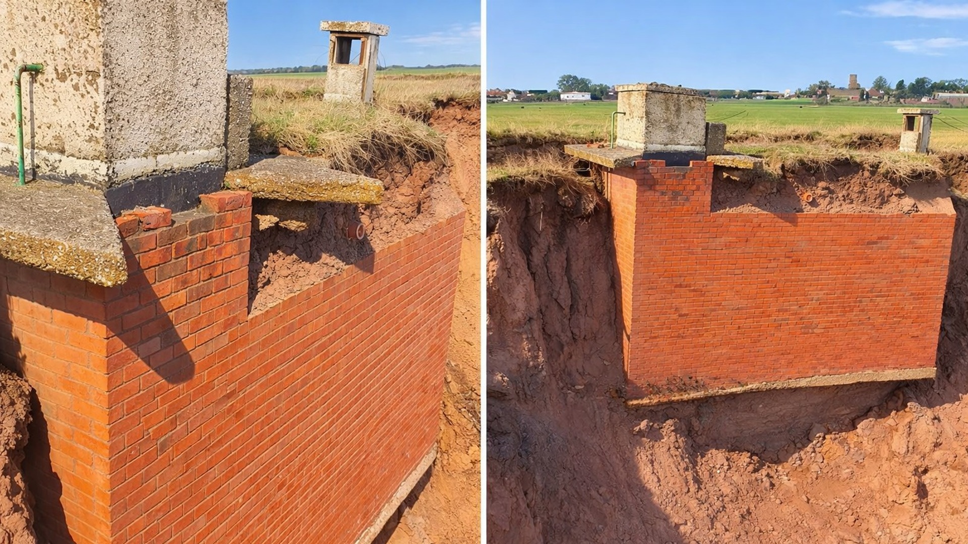


Built in 1959 as part of the Royal Observers Corps network for nuclear monitoring, the Tunstall bunker in East Yorkshire has lost about 100 meters of land to coastal erosion, is on the edge of an unstable cliff, and could fall into the sea in a matter of days, according to recent records
A Cold War nuclear monitoring bunker, built in 1959 and located near Tunstall on the Holderness coast in East Yorkshire, is about to collapse into the sea after decades of accelerated erosion that have drastically reduced the distance between the structure and the coastal cliff.
Cold War Structure Reaches Physical Limit After Decades of Coastline Recession
The bunker was erected as a Royal Observers Corps post during a period of heightened global nuclear tensions. When built, it was situated approximately 100 meters from the coastline, on land considered safe.
Today, the structure is literally on the edge of a steep cliff, with waves crashing against its base during high tide.
-
He started running at 66 years old, broke records at 82, and is now a subject of study for having a metabolic age comparable to that of a 20-year-old, in a case that is intriguing scientists and inspiring the world.

-
Oldest tree on the planet reappears after 130 years of searches: Wattieza, 385 million years old, was 10 meters tall and had no leaves or seeds; Gilboa fossils in New York solved the mystery in 2007.

-
A 48-square-meter house assembled in hours with 4,000 bricks made of recycled plastic that does not absorb moisture, has natural thermal insulation, and costs less than 90,000 reais in a complete kit.

-
Luciano Hang revealed that Havan’s air fleet has already accumulated more than 20,000 landings, 10,000 flight hours, and 6 million kilometers traveled, and he says that without the planes, the company would never have grown so quickly.

The extreme proximity to the sea indicates that the collapse could happen at any moment, possibly suddenly.
According to amateur historian Davey Robinson, who monitors the site daily, the bunker “doesn’t have much life left, maybe just a few days,” given the speed with which the soil around it is being taken by the sea.
Daily Monitoring Records Accelerated Erosion Progress Over the Bunker
Robinson and his partner, Tracy Charlton, have been visiting the site for over a week, filming the daily changes caused by coastal erosion. The recordings show larger and larger parts of the underground structure being exposed.
According to Robinson, the loss of land has been visibly occurring from one day to the next.
The advancement of the waves over the base of the cliff has been removing the support that kept the bunker stable.
The images posted online have begun to attract international attention, increasing public interest in the fate of the construction and the fragility of the East Yorkshire coast in the face of natural erosion processes.
Royal Observers Corps Post Never Used Operationally
The Tunstall ROC post was part of a national network of monitoring stations designed to detect nuclear explosions and radioactive fallout during the Cold War.
The structure was mostly underground, with only a small concrete block visible on the surface.
With the progression of erosion, red brick walls, internal divisions, and previously buried accesses have become visible.
The interior included dormitories and living facilities considered very basic for long stays.
In an interview with the BBC, Robinson explained that the bunker was designed to allow its occupants to remain on-site while monitoring potential nuclear explosions. According to him, despite the preparation, the post was never used operationally.
Holderness Coast Loses An Average of Two Meters Per Year, According to the Environmental Agency
The Environmental Agency classifies East Yorkshire as one of the UK’s coastal regions with the fastest erosion. On the Holderness coast, the average land loss rate is estimated at about two meters per year.
This ongoing process explains how a structure originally distant from the water has ended up exposed in just a few decades. The combination of waves, abrasion, and longshore drift gradually removes sediments from the cliffs and beaches in the area.
The effects are particularly intense in areas composed of sandy and clay-rich soils, as is the case in much of the Holderness coastline, making the recession of the coastline faster and more unpredictable.
Historical Land Loss Includes Entire Villages Since Roman Times
Records of historical geography indicate that approximately five kilometers of land have been lost on the Holderness coast since Roman times. At least 23 villages have disappeared over the centuries due to erosion.
In addition to territorial loss, the phenomenon often exposes or destroys historical and archaeological sites. In many cases, structures hidden for centuries are revealed only briefly before being swallowed by the sea again.
The Tunstall bunker fits into this context as a visible and recent example of the ongoing impact of erosion on historical heritage and the British coastal landscape, according to Robinson.
Collapse Expected to Occur Suddenly with the Continuation of Wave Action
Experts indicate that when the bunker collapses, it will likely happen quickly. The waves continue to undermine the base of the cliff that supports the structure, progressively reducing its stability.
Although there are coastal defenses in some areas of the UK, much of the Holderness coast remains unprotected. In these stretches, authorities often adopt planned retreat strategies.
For Robinson, watching the bunker physically moving toward the sea has become a concrete way to demonstrate the speed of coastal transformations. “Seeing something real moving shows exactly what is happening,” he stated.


Search Youtube for Timothys Travels for more videos on the Bunker