 Portuguese
  English
  Spanish
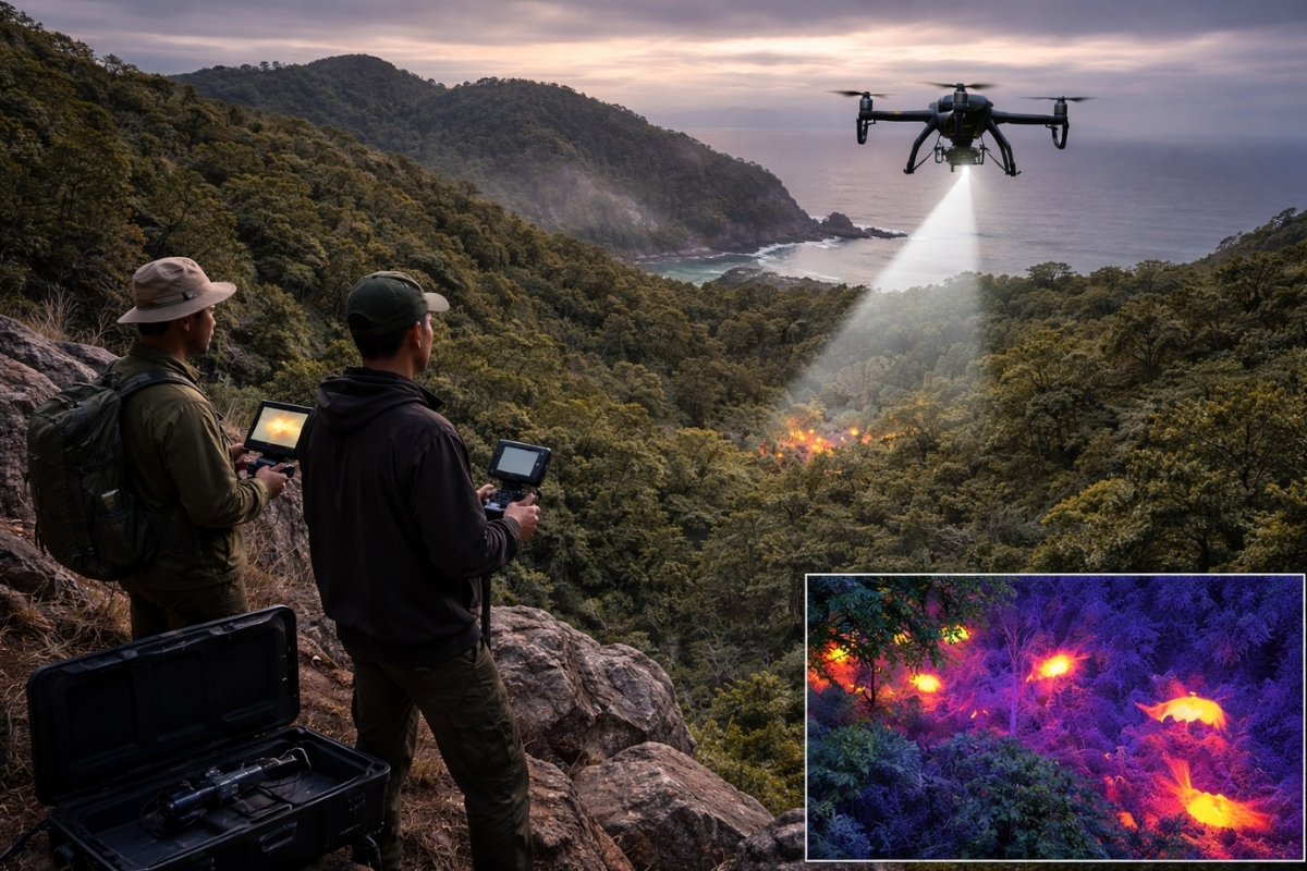
Thermal Vision Technology In The Air Shortens Ground Work And Changes The Pace Of Invasive Rodent Control In Remote Areas
Drones with thermal imaging are already being used in operations on islands to tackle a problem that undermines entire ecosystems: the presence of hard-to-locate invasive species.
The technology allows for identifying animal activity even when visibility is insufficient for a normal search, reducing time wasted on long and exhausting sweeps.
In practice, the change is evident in the teams’ routines. The drone covers complicated areas, and on-ground work becomes more targeted, with less exposure to risk.
-
With a cost per shot close to zero, the DragonFire laser could change naval warfare in 2027 and provide British ships with nearly unlimited defense against drones.

-
A British startup creates tires that generate electricity in electric vehicles when passing over potholes, speed bumps, and cracks.

-
Scientists have created robots made with living cells that have their own nervous system, swim on their own, explore the environment, and self-organize without any genetic engineering, and now they want to do the same with human cells.

-
Students create a solar-powered ambulance that operates without a plug, without fuel, and still keeps medical equipment running in remote areas.


Ua Pou Becomes A Real Test Bed For Drones To Spread Bait Where Humans Can Hardly Reach

On Ua Pou, in the Marquesas Islands, drones have begun to operate in a critical phase of control: spreading bait in hard-to-reach areas to combat invasive rats.
The terrain limits direct human movement and makes it difficult to maintain uniform coverage, especially in places where walking is slow and dangerous.
With the drone, the operation gains reach and repetition. The same type of mission can be redone and adjusted, reducing failures and improving the consistency of the action.
The Problem Is Not Just Capturing, It’s Finding The Invader When It Does Not Give Any Sign
On islands, invaders do not need to be seen all the time to cause an impact. It is enough for them to be present and reproducing to create continuous pressure on local fauna.
The practical challenge arises when the animal hides, changes behavior, and avoids contact. The search starts to depend on luck, trails, and long hours in the field.
The thermal image serves as an operational shortcut. It does not solve everything by itself, but it reduces the chance of an entire area being swept without results.
What Thermal Imaging Detects In Flight And Why It Helps When Light Fades

The thermal camera captures temperature variations in the landscape. This allows for detecting signs of animal presence even in conditions where a regular camera loses efficiency.
The advantage grows during low visibility times, when the human eye relies on a flashlight and the search becomes slower and more limited.
With the drone, the team can quickly read the scenario, identifying points where there is a real chance of activity and avoiding unnecessary movement.
Galápagos Also Joined The Route, Drones Help Spread Bait To Hard-To-Reach Areas And Expand Coverage
In Galápagos, drones have been used to spread bait focusing on controlling rats that threaten local fauna.
The logic is straightforward: reach areas where manual distribution would be more dangerous and less efficient, keeping the effort concentrated on critical points.
This type of use is gaining strength on islands with complicated terrain, where access defines the success or failure of the operation.
When The Drone Comes In, Ground Work Stops Being Full Sweep And Becomes Targeted Action
The operation changes profile when the drone begins to cover large and difficult areas. Instead of walking without certainty, the team moves with focus on priority locations.
This increases productivity and reduces wear. Less time searching means more time executing control measures with precision.
The impact is also human. Less exposure on slopes and unstable areas reduces operational risk and improves the safety of those working in the field.
Not Everything Appears In Thermal Imaging, And This Is Where Flight Planning And Ground Confirmation Come In
Thermal imaging has limitations in very closed environments, with dense vegetation, cavities, or deep hiding places.
The heat of the environment can also reduce contrast at times, requiring the selection of more favorable windows to increase the thermal difference.
Even so, the drone delivers a practical advantage: it accelerates screening and reduces the chance of decisions based solely on trial and error, maintaining final confirmation on the ground.
Drones with thermal imaging have changed the pace of invasive control on islands because they solve the most costly bottleneck of the operation: finding what is hidden.
By delivering bait to hard-to-reach areas and directing ground work, the technology accelerates the control of invasive rodents and reduces human risk in environments where every movement can become a problem.


-

-

-

-

-

31 pessoas reagiram a isso.