 Portuguese
  English
  Spanish
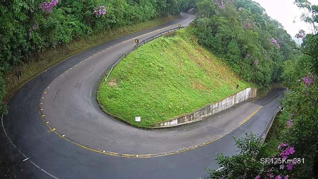
Oswaldo Cruz Highway, between Taubaté and Ubatuba, challenges drivers with tight turns, steep descents, and unpredictable weather amid the Serra do Mar, requiring technique, preparation, and increased attention throughout the journey.
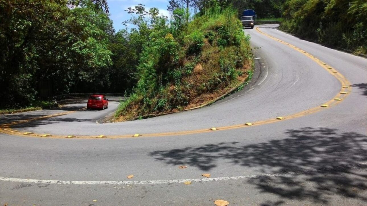
The Oswaldo Cruz Highway (SP-125), which connects Taubaté to Ubatuba, features one of the most demanding stretches in the country for those driving towards the northern coast of São Paulo.
On a total route of 91 km, the mountain imposes 17 km of tight turns, steep descents, and sections of reduced visibility, requiring skill, a well-maintained vehicle, and constant attention.
Ubatuba Mountain: Entry to the Coast and Test of Skill
The link between the Paraíba Valley and the coast, the road passes through an area of dense vegetation in the Serra do Mar.
-
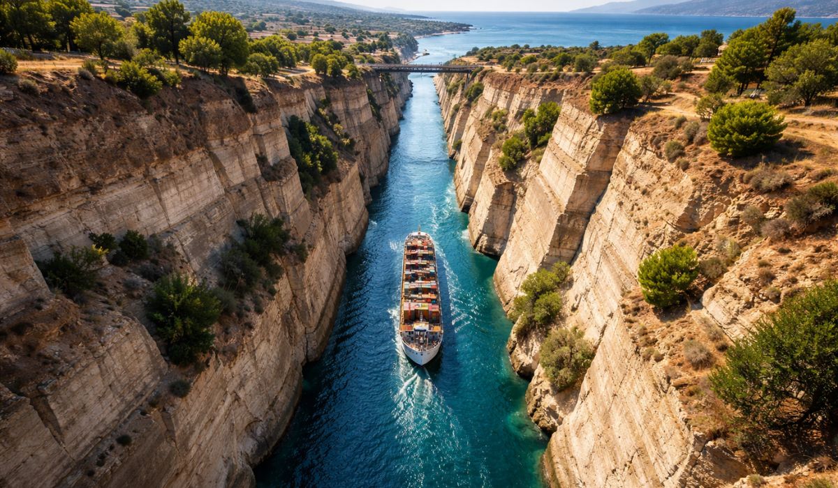
The longest public work in history began in Antiquity, spanned empires, was attempted by Nero, and was only completed 2,500 years later, turning the Corinth Canal into one of the most incredible stories of world engineering.
-
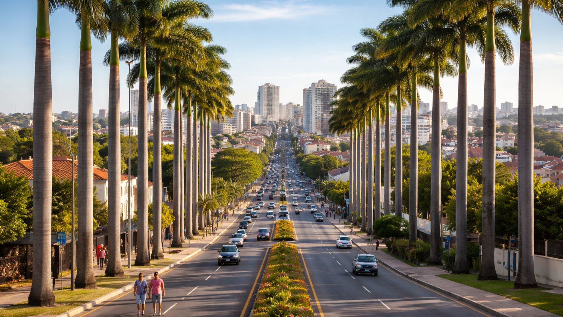
The USA invaded Brazil to create a city: founded after the war, the municipality of 250,000 inhabitants is the safest in São Paulo.
-
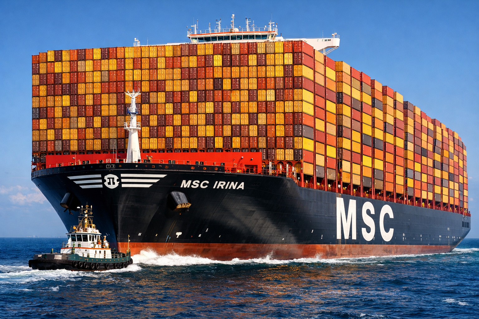
With a length of 399.9 meters and a capacity for over 24,346 containers, the MSC Irina becomes the largest ship in the world and revolutionizes global maritime transport.
-
With nearly 6,000 square meters and an investment of $100 million, the building that seems to move in Las Vegas has a reflective stainless steel façade, creates optical illusions, and has become a symbol of creativity worldwide.


The winding layout, combined with the altitude variations and the frequent climatic conditions in the region, creates a scenario where small mistakes can quickly turn into real risk.
This is not just about mastering the wheel: it is necessary to plan the trip, understand the limitations of the car, and respect every sign.
While the initial stretch departs from Taubaté towards São Luiz do Paraitinga, the final section descends towards Ubatuba with consecutive turns and long ramps.
On cloudy or rainy days, fog covers parts of the road, reducing visibility and extending the driver’s reaction time.
91 km in Length, 17 km of Intense Mountain
The entire itinerary sums up to 91 km, with approximately 39 km between Taubaté and São Luiz do Paraitinga and another 52 km to Ubatuba.
It is in this second segment that the so-called “mountain” forms, recognized for the combination of short radius turns, nearby guard rails, and steep inclines that demand fine control of speed.
The 17 km core is the most challenging part of the route, as it concentrates successive turns and stretches where the road seems to “disappear” after the tangent.
Due to the descents, driving in the wrong gear overloads the brakes and increases the risk of overheating, a situation that reduces system efficiency and extends the braking distance.
Avoiding this wear begins with the correct gear choice and continues with timely maintenance.
Why Engine Brake Is Indispensable
Experts emphasize the classic guidance: use the engine brake in manual transmission vehicles, maintaining intermediate RPMs and lower gears to hold the car on the ramps.
Proper use reduces reliance on the brake pedal, prevents thermal fatigue of components, and provides the driver with greater control over the vehicle.
In automatic cars, the manual mode or the available downshift positions on the selector help replicate the effect and stabilize speed in the curves.
Additionally, the correct tire pressure, checking the braking system, and ensuring the suspension is in good condition are critical for maintaining grip and trajectory precision.
The combination of these precautions offsets, in part, the road surface’s oscillations, moisture accumulation in shaded areas, and the presence of natural debris on the track.
Weather, Relief, and Invisible Risks
In the Serra do Mar, the microclimate creates subtle traps.
The shade of the tree canopies keeps the asphalt cold and damp at certain points even after the sun appears, favoring the formation of thin and barely visible water sheets.
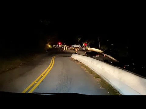
During rain periods, the likelihood of landslides increases, which can block lanes and surprise those approaching a curve without full visibility of what lies ahead.
Visibility also fluctuates with morning or nighttime fog.
In poorly lit sections, properly regulated and clean headlights make a difference, as does using speeds appropriate to the available field of vision.
Departing the Paraíba Valley under clear skies and encountering heavy drizzle just a few kilometers from the descent is common; therefore, adjusting your schedule helps avoid peaks of climatic instability.
Traffic Rules and Attention to Signage
There are restrictions on the traffic of trucks and buses at certain points of the highway.
The conditions of the terrain and the series of curves make some segments unsuitable for large vehicles, which requires carriers and professional drivers to consult regulations before starting their journey.
For passenger cars, vertical and horizontal signage anticipates curves, informs speed limits, and guides on areas where overtaking is prohibited.
Following them reduces conflicts and preserves space for emergency maneuvers.
Even though each driver knows their own reflexes, the road does not tolerate improvisation.
Sudden reductions in speed in a line, poorly calculated overtakes at the curve exit, and delays in resuming after the tangent are among the occurrences that most increase the chances of collisions.
Preventive Driving: Vehicle and Driver Preparation
The recurring recommendation for safely traversing the mountain involves a basic combo of care: checking brakes, tires, and suspension, aligning the vehicle, verifying fluid levels, and ensuring headlights and taillights are functioning.
Inside the cabin, a safety belt fastened for everyone, adjusted seats, and well-regulated mirrors enhance awareness of the surroundings and reduce fatigue during consecutive turns.
Another simple measure makes a difference: planning stops outside the mountain stretch to rest and regain full attention before the descent.
On trips with cargo or bulky luggage, weight distribution in the trunk and adhering to the vehicle’s limit help maintain grip and avoid unwanted sway in the turns.
When to Avoid the Trip
Whenever possible, adverse weather conditions should delay crossing the most critical stretch.
Heavy rain, thick fog, and recent incident reports on the track create an expanded risk scenario.
In these cases, waiting for improvement in the weather and consulting official bulletins before continuing the trip reduces exposure to unforeseen events, especially during cold fronts or after long periods of precipitation.
What to Do Inside the Mountain
Upon entering the series of curves, the tip is to anticipate commands.
Reduce before the curve, maintain a smooth trajectory, avoid prolonged braking, and resume speed only when the vehicle is stabilized, making driving more predictable for those behind.
In case of queues, maintaining a safe distance allows absorbing variations and prevents abrupt reactions.
A defensive posture is an ally in an environment where signage does not always reveal everything beyond the next turn.
Safety Begins with Attitude
The SP-125 combines natural beauty and technical complexity. Amid dense vegetation, the layout does not allow for distraction.
The best plan for crossing its 17 km of most demanding terrain continues to be a combination of increased attention, well-applied engine brake, vehicle in ideal conditions, and full respect for the signs.
With these elements, the path between the Paraíba Valley and the sea ceases to be an obstacle and becomes a controlled journey.
What other roads in Brazil do you consider as demanding as the descent of the Ubatuba Mountain, and why?


-

-

-

-

-

-

88 pessoas reagiram a isso.