 Portuguese
  English
  Spanish
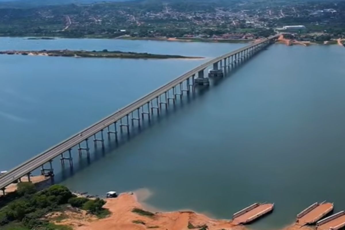


Abunã Bridge on BR-364 Ends the Ferry on the Madeira River, Strengthens the Pacific Route, and Transforms Logistics in Northern Brazil.
For decades, BR-364 reached its end on the bank of a brown river, silent, with the engine off and the smell of stagnant diesel in the air. To leave Rondônia towards Acre, it was necessary to face unpredictable ferry lines, hours of waiting, and a bottleneck that hindered logistics in Northern Brazil. With each flood of the Madeira River, the country learned the price of relying on a fragile river crossing in the heart of the Amazon.
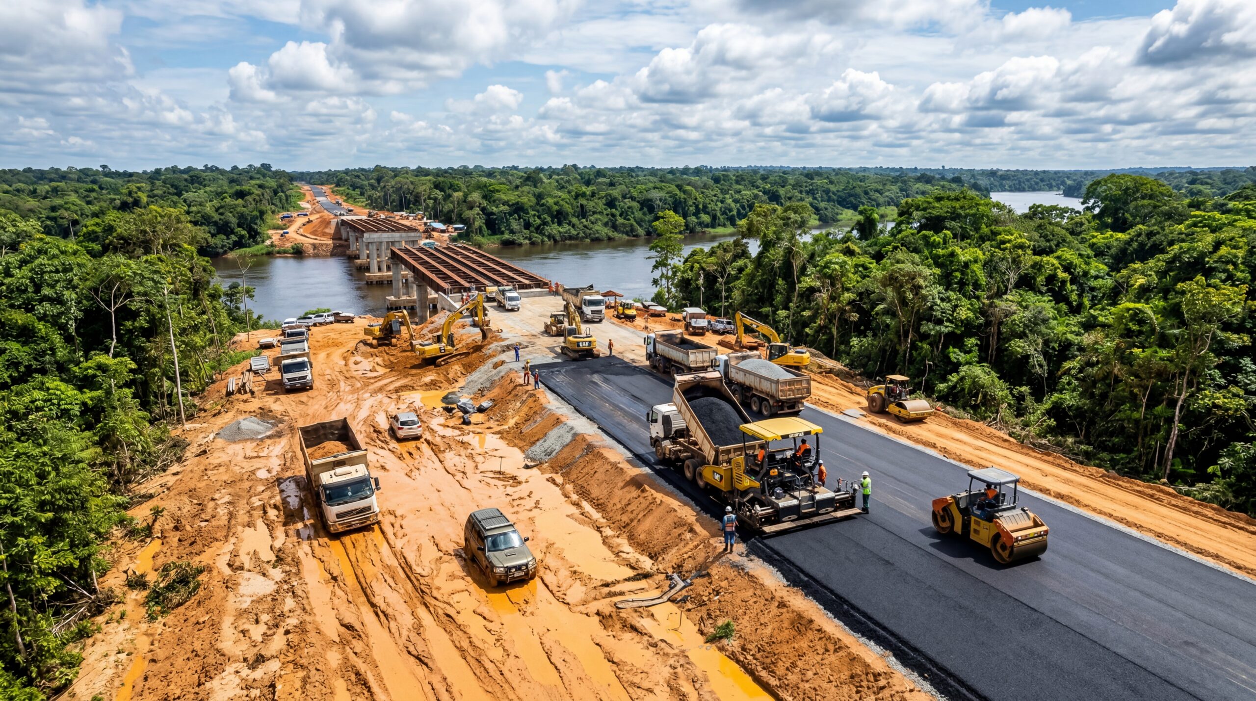
With the inauguration of the Abunã Bridge, 1.5 km of concrete over one of the most challenging rivers in Brazil transformed this limit into continuity.
What was once seen as a dead end has turned into a integrated highway corridor, bringing Acre closer to the Midwest, the Amazon, and the ports connected to Asia, elevating the logistics of Northern Brazil.
-
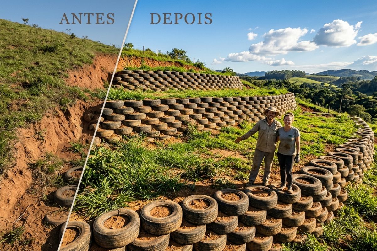
Couple shows how they built a retaining wall on their property using 400 old tires: sloped land turned into plateaus, tires are aligned, filled, and compacted with layers of soil, with grass helping in support and at almost zero cost.
-
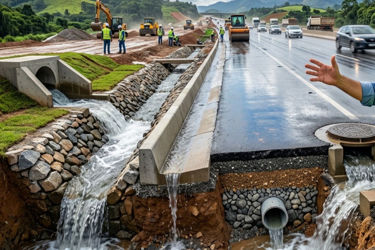
Engineer explains drainage during the rainy season: the difference between surface water and deep water, ditches, gutters, and water outlets on the road, as well as drains and drainage mattresses, to prevent erosion, aquaplaning, and flooding at the construction site today.
-
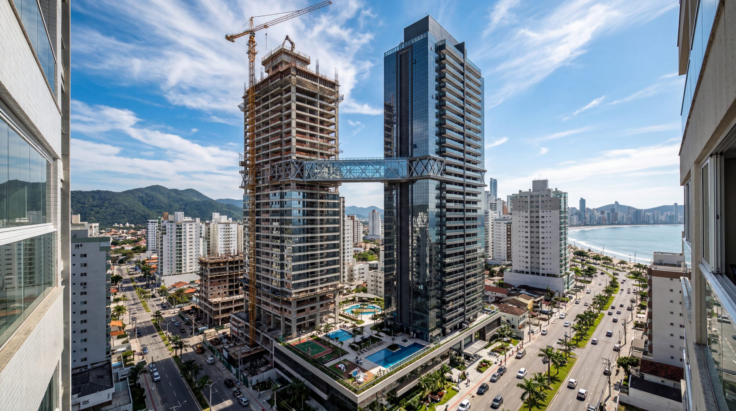
With 55 floors, 177 meters in height, a 15-meter walkway between the twin towers, ventilated facade, and 6,300 m² of leisure space, Ápice Towers already has one tower completed and another nearly at the top.
-
After nearly 50 years of neglect, BR-319 receives R$ 678 million to pave 340 km, gain a 320-meter bridge, and try to lift Amazonas out of the mud, the quagmire, and road isolation.
When the Road Ended at the River’s Edge

Before the bridge, the scene was always the same: line of trucks stopped, stifling heat, the sound of wood floating down the river, and a slow ferry deciding the pace of the journey. Between the Madeira River and the Abunã River, the division was not just geographical; it was economic and logistical.
The BR-364, the backbone of Acre in the east-west axis, simply stalled in the water. The ferry crossing at Abunã was the only roadway link between the state and the rest of the country.
In 2014, a historic flood inundated sections of the highway, paralyzed the ferries, and isolated Rio Branco from other Brazilian capitals for an extended period.
In practice, this meant:
- rationed fuel
- skyrocketing prices
- bare minimum supply
- clear feeling that Acre was on the map but not fully connected to Brazil
Even on “normal” days, the crossing weighed heavily on the budget: truck drivers paid around R$ 200 per vehicle, adding to the direct cost the time spent waiting, the risk of theft, and the total unpredictability of the line. All this affected the freight rates, which ultimately influenced the price of rice, beans, cement, and any goods relying on BR-364.
At the same time, the country was pushing the agricultural frontier into Mato Grosso, Rondônia, and the Amacro region, targeting markets in Asia and the Pacific.
It was a Brazil trying to project itself outward, with a typical Amazonian bottleneck from the last century in the way.
Where the Bridge Fits into the Logistics of Northern Brazil
The Abunã Bridge is located in the district of Vista Alegre do Abunã, in the far west of Rondônia, right where BR-364 needs to cross the Madeira River toward Acre.
It is positioned almost halfway between Porto Velho and Rio Branco, in a strategic area of the Amacro region, connecting parts of Amazonas, Acre, and Rondônia.
With about 1,517 meters in length and just over 14 meters wide, with two lanes, shoulders, and sidewalks, the bridge is one of the largest roadway structures over freshwater in the country.
According to DNIT, around 2,000 vehicles cross this section daily, reducing a ferry crossing that could take up to 2 hours to less than 5 minutes of continuous asphalt.
In practice, this means:
End of the daily dependence on the ferry;
Elimination of the last roadway isolation link of Acre;
Establishment of a direct corridor between the Midwest, the Amazon, and the roadway route to the Pacific.
From this point forward, the logistics of Northern Brazil changes scale. Trucks leaving Rondônia and the west and north of Mato Grosso, loaded with grains and meats, can now flow continuously along BR-364 to Acre and then via BR-317 and Pacific Route to the border with Peru and the ports for export to Asia.
Engineering to Tame the Madeira River
From an engineering standpoint, the Abunã Bridge is above all a negotiation with an unstable and powerful river. The Madeira is wide, deep, experiences significant level variation between high and low water, and carries entire trunks down with the current, which collide and accumulate on the structures.
The original project envisioned just over 1,047 m in length, but geotechnical and hydrological studies showed that to protect the highway from floods like that of 2014, it would be necessary to raise the road grade and move the abutments out of the flood zone. The solution was to add about 460 m of viaduct on solid ground, creating three distinct sections:
Raised segment on firmer ground;
Section over the shallower bed;
Navigable central span over the main channel of the river.
This adjustment also required almost 1.5 km of embankments on the accesses, smoothly connecting BR-364 to the platform and reinforcing the structure against future floods.
Below ground, the challenge was different. The alluvial plain of the Madeira is characterized by soft and saturated soils with low bearing capacity.
To anchor the structure, approximately 145 deep piles were driven into more resistant layers, in operations carried out from ferries and floating platforms under strong currents and fluctuating water levels.
On this foundation, a structure was built that consumed tens of thousands of cubic meters of concrete and thousands of tons of steel, combining conventional beam sections with a navigable span executed in successive cantilever.
In this method, concrete segments are built from the piers, advancing over the river like arms growing from both sides until they meet in the middle, with millimeter precision.
While the superstructure was rising, the geotechnical and earthmoving team struggled with the embankment of the accesses.
In soft soil, large volumes of fill can create settlement and unevenness between the road and the bridge. It was necessary to control the loading speed, execute sections in phases, and monitor deformations to prevent the classic “step” of many highways over floodplains in the future.
The schedule, initially planned for about 4 years, ended up being extended. Along the way, there were ferries colliding with the construction piers, exceptional floods interrupting concrete placements, and at the final stretch, the Covid-19 pandemic reducing work fronts and affecting supply lines deep in the Amazon.
What Does It Cost to Change an Entire Corridor
Although it’s not an “megabridge” in an urban setting, the Abunã Bridge stands out as a major regional project with national impact.
With around R$ 150 million to R$ 154 million in investments, the average cost is about R$ 100,000 per linear meter, a level expected for an extensive structure over a mighty river, with deep foundations and significant water level variation.
Compared to the old ferry operation, the contrast is clear. Before:
A heavy truck paid just over R$ 200 per crossing;
The daily flow included a significant number of freight vehicles;
The system could generate tens of millions of reais per year just in tolls, not to mention the diesel burned and the time lost waiting in line.
Now, this toll barrier disappears, and the crossing becomes just another section of BR-364. The investment in concrete and steel pays off in:
Reduction of logistical costs for carriers and shippers;
Gains in travel predictability;
Lower operational risks for supply chains reliant on deadlines (such as perishable food and refrigerated cargo).
In terms of materials, the tens of thousands of cubic meters of concrete used are equivalent to that needed for a set of medium-sized residential buildings, while the thousands of tons of steel resemble the structural volume of a small stadium.
It’s the scale of infrastructure typically associated with major urban centers, now serving the logistics of Northern Brazil in the heart of the Amazon.
What Changes for Acre, for the Amazon, and for the Logistics of Northern Brazil

In the short term, the most tangible effect of the Abunã Bridge appears in the pockets of those who depend on the road.
No ferry toll and reduced travel time, transportation costs decrease, allowing for lower prices of food and construction materials, especially for the lower-income population in Acre.
Regionally and nationally, the bridge consolidates Acre as a functional part of the federal roadway network. It strengthens the corridor Porto Velho, border with Peru via BR-317, and the Pacific Route, which allows:
- Grains and meats from the Amacro region to reach Peruvian ports bound for Asia more quickly
- Refrigerated cargo and higher added value products to gain competitiveness on international routes
- The logistics of Northern Brazil to shift from being merely an issue to being seen as a platform of opportunities
However, this advancement comes with dilemmas. The same infrastructure that connects markets can accelerate the unplanned expansion of the agricultural frontier, repeating the deforestation–timber–livestock–grains cycle already seen in other regions.
Moreover, the bridge removes a bottleneck but does not eliminate climate vulnerability. Extreme events in the Amazon can still disrupt roads, affect waterways, and pressure entire communities.
That’s why many studies advocate for a more resilient and multimodal network, combining highways, waterways, and intermodal terminals instead of relying on a single axis.
In summary, the Abunã Bridge is a decisive step, but it is not sufficient on its own. It needs to be accompanied by:
Territorial planning and environmental control;
Land use policies that prevent surges of deforestation;
Complementary investments in infrastructure, oversight, and public services.
Only then can the logistics of Northern Brazil become more efficient without sacrificing the ecological base that sustains the economy of the region.
Ultimately, the Abunã Bridge is not just concrete and steel over the Madeira River. It is a technical response to historical isolation, condensing in 1.5 km of roadway the difference between being on the margins and being fully integrated into the country and global trade corridors.
What do you think, will this new connection bring more benefits or more risks to the Amazon and Acre’s economy in the long run?


Moro em RONDONIA essa ponte e uma boa coisa, pois na seca o transito ate parava, parabens ao gov. e de maneira respeitosa digo q quem a concluiu foi o sr. BOL
Em um governo sem corrupção as coisas acontecem, parabéns presidente Bolsonaro! Logo ,logo o desgoverno LULA-LADRÃO vai lá inaugurar e dizer que foi ele que fez,ROUBAR, MATAR e Destruir é a especialidade do Partido das ****,demônios fantasiados de humanos!
O rapazinho é bem mal informado. Como todo **** só fala ****. Pra seu conhecimento são todos ****, cara !!!
Não salva ninguém… Isto por que pessoas como vocês não sabem votar.
O Bolsonaro tá preso ****.
O Bolsonaro tá preso B A B A C A.
Excelente texto! Mas as fotos ilustrativas não são da Ponte do Abunã.